
8 January 2021
Brumadinho: signs of precursory deformation
Posted by Dave Petley
Brumadinho: signs of precursory deformation
The January 2019 Brumadinho tailings dam failure in Brazil remains one of the most serious mine waste failures in recent years. Despite the terrible toll, a positive legacy appears to be a genuine attempt by the mining industry to improve the management of these facilities, although we will wait to see how effective this proves to be in the long term. Mining is an industry littered with promises of improvement that have not been delivered.
The report of the Expert Panel came to a very surprising conclusion, which is that the dam showed no signs of distress prior to the collapse. This is a finding that has caused considerable concern. If a dam can collapse on this scale with no obvious short term external trigger and no indications of impending failure, then it becomes extremely difficult to know how to monitor these facilities. This is the wording in the report:-
The failure is also unique in that it occurred with no apparent signs of distress prior to failure. High quality video from a drone flown over Dam I only seven days prior to the failure also showed no signs of distress. The dam was extensively monitored using a combination of survey monuments along the crest of the dam, inclinometers to measure internal deformations, ground-based radar to monitor surface deformations of the face of the dam, and piezometers to measure changes in internal water levels, among other instruments. None of these methods detected any significant deformations or changes prior to failure. Post-failure satellite image analyses indicated slow and essentially continuous small downward deformations of less than 36 millimeters per year (mm/year) were occurring on the dam face in the year prior to the failure, with some acceleration of deformation during the wet season. In the lower part of the dam, the deformations measured in the 12 months prior to failure included horizontal deformations ranging from 10 to 30 mm. Such deformations are consistent with slow, long-term settlement of the dam, and would not alone be indicative of a precursor to failure.
However, there is hope at hand. A new open access paper, published in the journal Communications Earth and Environment (Grebby et al. 2021), has used a version on the well-known InSAR methodology called the Intermittent Small Baseline Subset (ISBAS) to evaluate deformations in the dam and in the tailings themselves in the period leading up to the failure. This is a really important and valuable study, originating from an independent multidisciplinary team from industry and academia. Crucially, their findings differ significantly from that of the expert panel. This is what the paper says:
We observed widespread deformation across the dam wall and tailings from two independent satellite tracks, revealing areas subject to consolidation settlement. However, in contrast to attempts using other InSAR techniques, we also detected evidence of anomalous deformation not consistent with consolidation on the dam wall and tailings beach, instead exhibiting a clear accelerated rate of deformation from about late October 2018 following a period of increased rainfall.
It is worth diving into this a little. The InSAR technique can provide a time history of deformation for both slopes and sediment stores, alongside maps of the deformation. This is one of the figures from Grebby et al. (2021):-
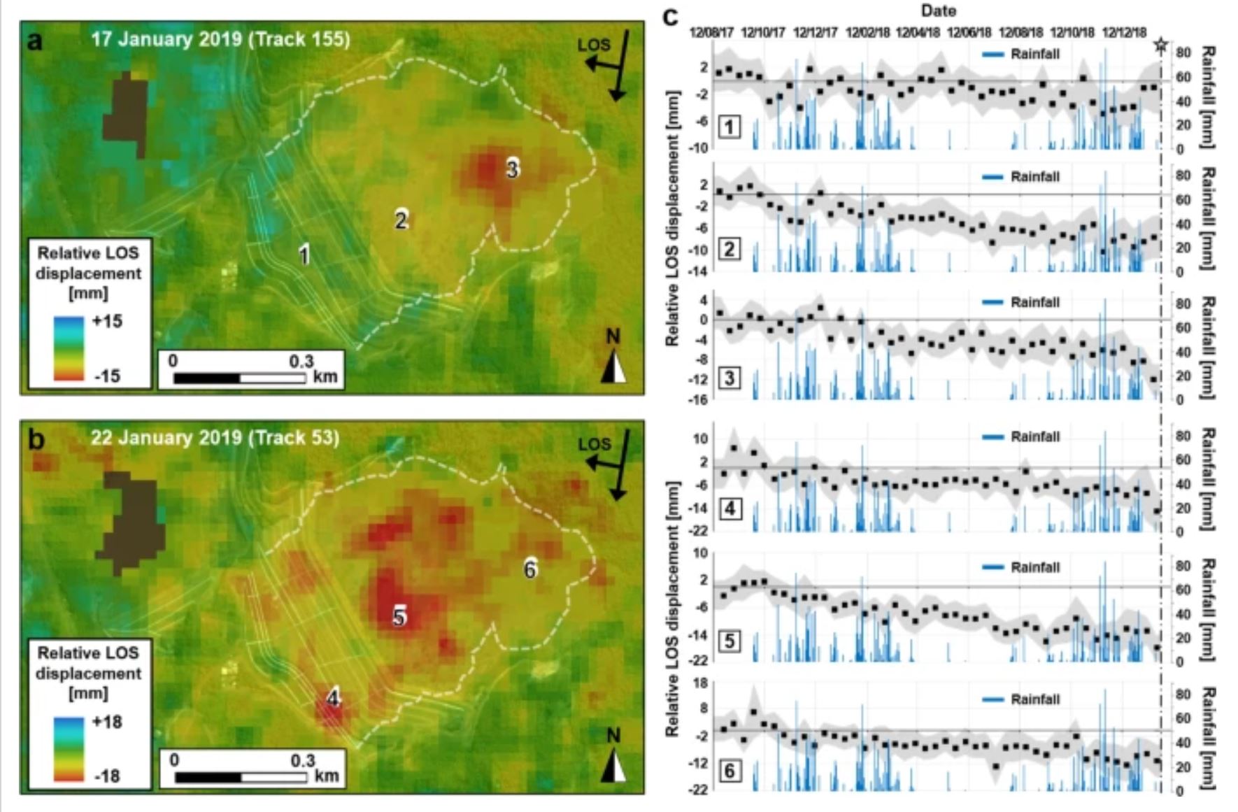
The Brumadinho tailings dam deformation time history and distribution, from Grebby et al. (2021).
.
InSAR measures deformation along the line of sight of the satellite. The analysis used two different tracks of the satellite (in this case using Sentinel-1 C-band data) with different incidence angles, so two different deformation maps have been produced. Note that the general trend is subsidence, especially across the surface of the trainings but also in parts of the tailings dam. This is not dissimilar to the findings of the Expert Panel report.
However, Grebby et al. (2021) have found that the time history of the deformation is rather more complex than had been indicated previously. In particular they note that:
The results illustrate that some distinctive deformations observed on the dam wall, and front and back of the tailings beach were … nonlinear
The data suggest that across parts of the tailings pond the sediment was undergoing slow settlement at an approximately constant rate through most of 2018, but in November and December the rate of deformation started to accelerate. Over time through the back end of 2018 and January 2019 the area undergoing this rapid deformation increased as well.
There is an established technique for evaluating the time of failure for slopes called the inverse velocity method – I have undertaken some work on this approach. In some slopes (in general those undergoing brittle failure) the pattern of acceleration is hyperbolic with time. This means that if the inverse of velocity is plotted against time then a linear trend is generated. Failure occurs when 1/velocity is zero. This plot allows the time of failure to be predicted; in a range of settings it has been proven to be remarkably effective. It is an approach that is often used, with considerable success, in the monitoring of high wall mines for example.
Grebby et al. (2021) have plotted inverse velocity against time for these areas in which there was rapid acceleration:-
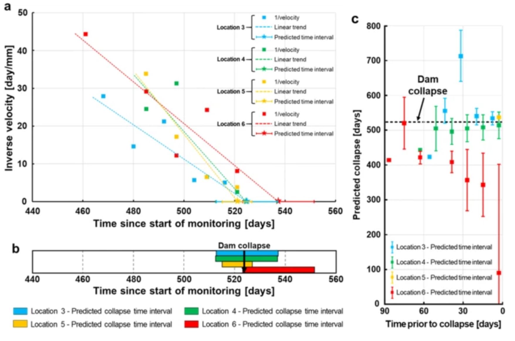
The 1/v – time plot for the Brumadinho tailings dam , from Grebby et al. (2021).
.
These are complex plots, and the data is noisy, meaning that analysing a single point is challenging. But if the ensemble of points is used the conclusion is that there was a linear trend in the inverse velocity graph (indicating that the sediments were following a brittle path to failure) and that the time of the dam collapse could have been predicted within a few days.
This is a really important finding for two reasons:
First, it implies that really high quality monitoring, and analysis of the data, could have allowed a warning to be given that the Brumadinho dam was developing serious stability issues. This is crucial – a separate (also open access) study (Lambruso et al. 2021) has found that a even a short term warning of dam failure would have saved many lives.
Second, it shows that even tailings dams that undergo very rapid failure probably show signs of distress that can be detected with appropriate monitoring and expert analysis of the data. This is reassuring for the mining industry, and the regulators, who will now need to step up to the plate to enact these systems.
References
Grebby, S., Sowter, A., Gluyas, J. et al. 2021. Advanced analysis of satellite data reveals ground deformation precursors to the Brumadinho Tailings Dam collapse. Communications Earth and Environment 2, 2. https://doi.org/10.1038/s43247-020-00079-2
Lumbroso, D., Davison, M., Body, R. and Petkovšek, G. 2021. Modelling the Brumadinho tailings dam failure, the subsequent loss of life and how it could have been reduced. Natural Hazards and Earth System Sciences, 21, 21–37.
 Dave Petley is the Vice-Chancellor of the University of Hull in the United Kingdom. His blog provides commentary and analysis of landslide events occurring worldwide, including the landslides themselves, latest research, and conferences and meetings.
Very interesting. How does the actual time of failure compare with the prediction based on the inverse velocity plots?
Very interesting. How does the actual time of failure compare to the prediction based on the inverse velocity plots?
I don’t know much about this technology – but I would be curious to see if applying this to other sets of data (dams which are deforming but not collapsing) may result in false positives? It is much easier to predict something using the power of hindsight. The expert report seems to say they thought the deformations were too small to be reliable measurements. Really interested to read more case studies.
Regarding the possibility of false positives, I wonder if there were other groups of 3 to 5 successive datapoints within the 18-month monitoring window that suggested impending failure. It might be fair to allow that these could occur, without invalidating in any way the usefulness of the approach.
Dear Dave,
The Grebby, S., Sowter, A., Gluyas, J. et al. 2021 paper is a quite detailed “post-mortem” review of the failure incident based on remote-sensing data its findings do add more discussion points to the Report of the Expert Panel which reviewed the hard monitoring data.
Expert Panel report says (as you quoted) “….Post-failure satellite image analyses indicated slow and essentially continuous small downward deformations of less than 36 millimeters per year (mm/year) were occurring on the dam face in the year prior to the failure, with some acceleration of deformation during the wet season. In the lower part of the dam, the deformations measured in the 12 months prior to failure included horizontal deformations ranging from 10 to 30 mm. Such deformations are consistent with slow, long-term settlement of the dam, and would not alone be indicative of a precursor to failure.” whereas,
the Grebby, S., Sowter, A., Gluyas, J. et al. 2021 paper says (as you also quted above) ” We observed widespread deformation across the dam wall and tailings from two independent satellite tracks, revealing areas subject to consolidation settlement. However, in contrast to attempts using other InSAR techniques, we also detected evidence of anomalous deformation not consistent with consolidation on the dam wall and tailings beach, instead exhibiting a clear accelerated rate of deformation from about late October 2018 following a period of increased rainfall.”.
It is my opinion that “PERIOD OF INCREASED RAINFALL” is the main culprit (factor) in causing the accelerated rate of deformation.
If you would recall, I had shared a brief infoNote “InfoNote on the Córrego do Feijão Mine “Dam I” Failure dated 29 Jan. 2019” in this blog; which brought up the issue of Excessive Rainfall issue. There, my point was that there was no diversion channel on the upstream of the tailings dam reservoir where any rainwater had been entering the tailings directly. Here was an excerpt from my earlier infoNote:
“Reportedly, an extensive monitoring instrumentation was in place and due inspections were done; however:
• There is no apparent diversion channel(s) upgradient of the Dam I to prevent intrusion of surface run-off from the precipitation catchment area (approx. 480,000m2). Any heavy rainfall water falling in this catchment area will directly come into Dam I. Additionally, Tailings Dam Top Surface area is approx. 240,000m2 which will collect direct precipitation.
• Average precipitation in the months of December and January are reportedly total about 30cm for each month. This means about 0.9 meters of water column is placed over the dam surface (without evaporation):
(480.000 + 240,000)m2 x 0.3m= 216,000 m3 rainwater ; 216,000 m3 / 240,000 m2 = 0,9 m water column in December and January.
• This excessive rainwater needed to be discharged to have for “a rigid water level control using both proper decanting and spigotting procedures to maintain a 100 m minimum distance between the pond’s edge and the embankment crest”; otherwise, this ponded water would increase the phreatic levels in the tailings AND would expedite (with any triggering mechanism) the slow liquefaction process starting from the upgradient parts of the tailings mass moving towards downstream dyked front surface of the dam.”
The displacement data and the Insar Methodology data are very valuable and both have merits in evaluating the stability of the tailings dams; however, both would have failed to provide an “early warning” of failure. In post-mortem, their values can be discussed.
As an engineering geologist and a mining engineer with 50 years of experience, it is my opinion that the main cause of this failure is “non-presence of a diversion channel to route out the heavy rainfall from the reservoir area” which increased the interstitial/pore water pressures building up behind the dam face. Bulging in the dam face in the first 15 seconds of the failure, is something to note.
The dam stability was OK for the last 10 years, as monitored routinely. But the excessive precipitation water entering directly into the tailings mass in the reservoir “likely broke the straw”.
Best regards….
Caner Zanbak
Environmental Coordinator, Miners Association of Turkey
Thanks to Dave Petley for providing a platform for this discussion.
I’m with Caner Zanbak on this one. There is nothing statistically special about the time period analysed, the same method would have predicted collapse along many other similar length chunks of the time series. There is steady creep, all the Brumadinho InSAR papers agree with that, but the variance in the time series is consistent with noise, not acceleration.
I also have reservations about the “3-point moving average filter prior to the calculation of the inverse velocities”. From Fig 2, take location 5 for example: Just before the last scene was acquired, it shows slow displacement towards the satellite, then a sharp motion away just before failure, yet the inverse velocity graph shows it continuously accelerating. The smoothing implies that acceleration was detected at the centre of their time kernel, but it’s only really based on that last point.
Full disclosure, I am an InSAR specialist, colleagues of mine wrote a paper that concluded there was displacement consistent with ongoing creep – but no pre-cursors to failure (https://papers.acg.uwa.edu.au/p/2025_15_Holden/). We analysed this data as well as the TerraSAR-X and Cosmo-SkyMed data sets. The expert panel’s findings that agreed with that, came after our paper. I am also good friends with one of the authors of the Grebby paper (and hope to remain so :-). Whilst we compete commercially, it is absolutely not my intention to score points, I just don’t want people to come away from this with a false impression of the technology.