9 September 2019
The impact of the 2017 Mocoa debris flows
Posted by Dave Petley
The impact of the 2017 Mocoa debris flows
The 2017 Mocoa debris flows in Colombia, which resulted in the deaths of 409 people, were the worst landslide disaster in that country for some years. I wrote about the tragedy at the time, and have also highlighted an article published earlier this year investigating the causes and effects of this rainfall induced disaster. A new paper has been published in the journal Landslides (
First,
Second, t

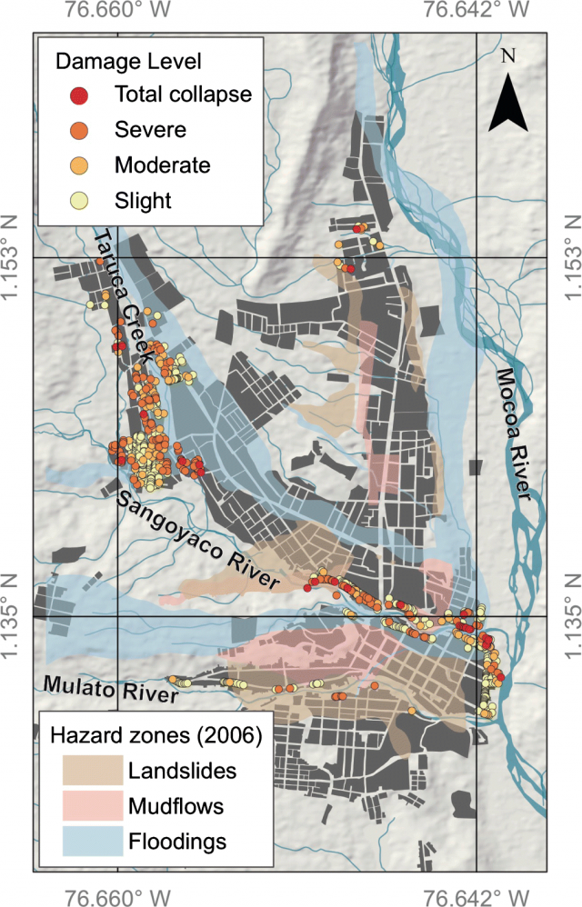
The damage to structures caused by the 2017 Mocoa debris flows. The shading indicates the 2006 hazard map that formed the basis for land use planning. Map from Prada-Sarmiento et al. (2019).
.
As observe:-
“In terms of damage, we can see that the hazard zoning strategy defined prior the event correctly identified several areas in which flooding and mudflows took place. However, it must be highlighted that this strategy does not explicitly consider large debris flows, which were responsible for most of the casualties and damage caused by the 2017 event. This analysis clearly reveals a need to incorporate good-quality information about multiple hazards in the municipal land used plans and the design of consequent mitigation strategies.”
This is a lesson that applies in many other places. The town is now protected by an early warning system, which reportedly performed well in the 2018 event, and will hopefully prevent a repeat of the 2017 Mocoa debris flows.
Reference
Prada-Sarmiento, L.F., Cabrera, M.A., Camacho, R. et al. 2019. The Mocoa Event on March 31 (2017): analysis of a series of mass movements in a tropical environment of the Andean-Amazonian Piedmont. Landslides. https://doi.org/10.1007/s10346-019-01263-y.


 Dave Petley is the Vice-Chancellor of the University of Hull in the United Kingdom. His blog provides commentary and analysis of landslide events occurring worldwide, including the landslides themselves, latest research, and conferences and meetings.