
18 June 2019
The Global Fatal Landslide Database: full dataset now online
Posted by Dave Petley
The Global Fatal Landslide Database: full dataset now online
Thanks to the hard work of Dr Melanie Froude, my colleague here at the Department of Geography at the University of Sheffield, we have now posted the full Global Fatal Landslide Database online. This is the dataset that underpins our paper of last year (Froude and Petley 2018) that explored the human cost of landslides from 2004 to 2016 inclusive. However, this new version adds a further year of data, covering 2004 to 2017 inclusive.
The dataset can be accessed via an ARCGIS web application, which allows mapping of the dataset at a range of scales. The full dataset looks like this:-
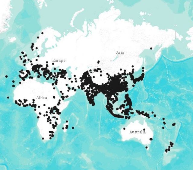
A simple map of the Global Fatal Landslide Database.
.
Whilst the application allows mapping at the national scale – this is the area around Nepal for example:-
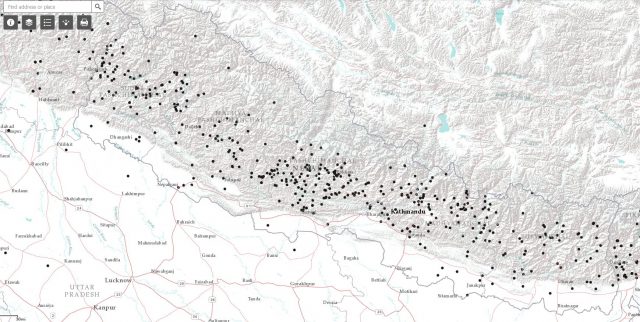
The Global Fatal Landslide Database: an example of a national level map – the distribution of fatal landslides in the area around Nepal.
.
And more detailed mapping is also possible – this is the distribution of fatal landslides on the island of Java in Indonesia:-
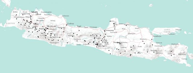
An example of a map from the Global Fatal Landslide Database – the distribution of fatal landslides on the island of Java in Indonesia.
.
Over the last couple of years, Melanie has remapped all of the landslides to verify their locations. In each case a polygon has been constructed that define the area in which we believe that the landslide has occurred. In some cases this polygon defines the landslide itself; in others it defines for example the village in which the landslide happened (where this is the most precise description that we have found). The mapping tool allows you to display this data, or the centroid of the polygon to generate a point.
Melanie has written a guide to the dataset, which can be found here:
https://drive.google.com/file/d/1FGI4cQuykv_CqPSd2Fe_x0Djqc6K8XWh/view
This provides full details of the dataset, and of course its limitations.
Perhaps most importantly, the full dataset is now available to download. The manual provides detail of how to do this, via a free public ARCGIS account. We have released the data as an asset for free public use. However, please acknowledge the following open source license and acknowledge the source of the data by citation. The dataset is covered by a University of Sheffield copyright and database rights reserved 2019. For the full license see
http://www.nationalarchives.gov.uk/doc/open-government-licence/version/2/
When using data in a publication, please cite the following reference:
Froude, M. J. and Petley, D. N. 2018. Global fatal landslide occurrence from 2004 to 2016. Natural Hazards and Earth System Science, 18, 2161-2181, https://doi.org/10.5194/nhess-18-2161-2018.
This paper is open access, so should be accessible to all.
If you are struggling to download the data, it is also temporarily available via a Google Drive folder:-
https://drive.google.com/open?id=1kxUSXBl10OHPrGXIur6bM4PBoKX0C_LY
This contains zipped shape files for each data layer.
Melanie and I hope that you will find both the web app and the dataset to be useful. Putting this dataset together has been a huge piece of work, which I started in September 2002 and continue today (so almost 17 years, and counting), whilst the mapping of the landslides, and the collation of the dataset, has been thousands of hours of work by Melanie. However, we believe that the effort has been worthwhile, and the work will continue for the foreseeable future.
 Dave Petley is the Vice-Chancellor of the University of Hull in the United Kingdom. His blog provides commentary and analysis of landslide events occurring worldwide, including the landslides themselves, latest research, and conferences and meetings.
Fascinating! Is the absence of landslides in Russia and China a genuine one, or a result of lack of data?
[There’s certainly no absence in China. In Russia, we record few fatal landslides. This may be a reporting problem, but it is hard to know. D.]
Good work! Are you interested in recieving missing fatalities?
[Yes please. D.]
MANY THANKS to Dave and Melanie for their hard work and for making the data PUBLICLY available!!!!!!!!!!!!!!!!!!! I am doing global research on landslides and have had great difficulty in obtaining source data. The only way we can hope to truly get ahead of these devastating natural hazards is to have good data. I can’t wait to look at the data. I am truly grateful.
Cheers
Laurie J. Kurilla
All is a go this side of planet earth. Thankyou. 18yrs this year.
This is a great study. Thank you for your good work. Many will be benefitted from your hard work.
Very valuable work
Muchas gracias! i study geology and i´m doing my initial practice in make an inventory of landslides for develop a predictive model in the Patagonia, it´s very difficult to obtain good datasets so you are the best! regards from Chile, if my profesor allow me i gladly share the results 🙂