
18 September 2018
Drone images of the Barangay Ucab landslide
Posted by Dave Petley
Drone images of the Barangay Ucab landslide
The loss of life from the Barangay Ucab landslide has now reached 54 people; the search for victims continues. There is now agreement that there is no possibility of further survivors. Sadly, it is thought that 42 people remain missing, potentially making this one of the most deadly landslides of the year to date.
On Twitter, Mohammed Abdiker (Director of Operations and Emergencies at the International Organization for Migration – the UN migration agency) has posted a set of images collected by drone of the Barangay Ucab landslide. These reveal for the first time the nature of the landslide:-
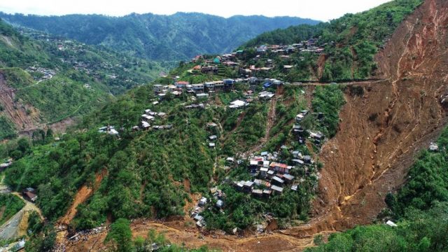
The Barangay Ucab landslide in the Philippines. Drone image posted to Twitter by Mohammed Abdiker.
.
This image shows that the landslide was a large, comparatively deep-seated slide in deeply weathered regolith. It appears to me that the slide transitioned into a channelised flow once it reached the channel; it is this flow that appears to have destroyed the accommodation block. This image shows the channel downstream of the landslide source, including some of the destroyed structures:-
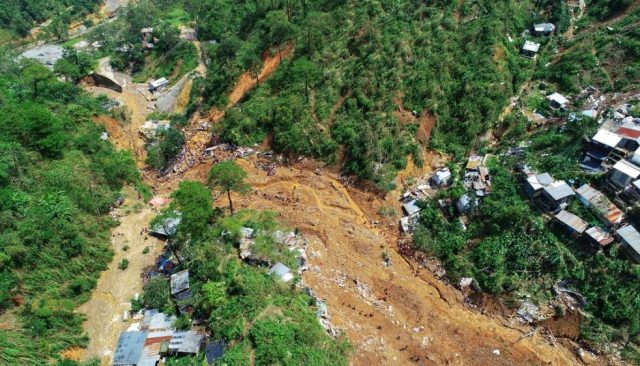
The lower reaches of the Barangay Ucab landslide in the Philippines. Drone image posted to Twitter by Mohammed Abdiker.
.
Notably, most of the debris appears to have left the channel and entered the main river. This may explain why so many victims have not been recovered as yet. The image below shows the channel in more detail. Note the people for scale – this provides a sense of the magnitude of this landslide. The vulnerability of the buildings is also clear, as is the presence of many other landslides in addition to the one that caused such high loss of life:-
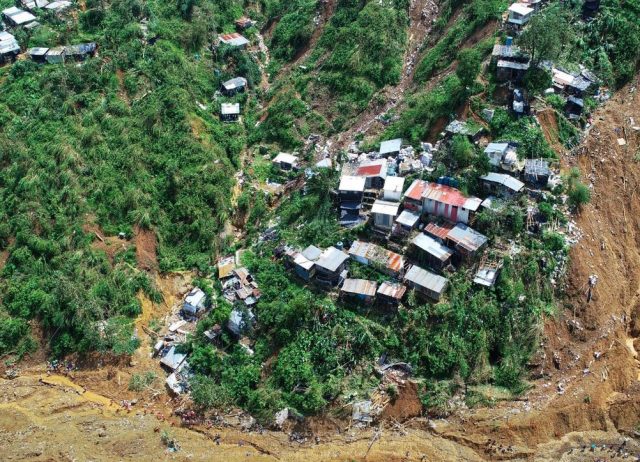
The scale of destruction at the Barangay Ucab landslide in the Philippines. Drone image posted to Twitter by Mohammed Abdiker.
.
In terms of the cause of the landslide, I suspect that the investigation might like to look carefully at the road that crosses the slide. This part of the first image provides more detail:-
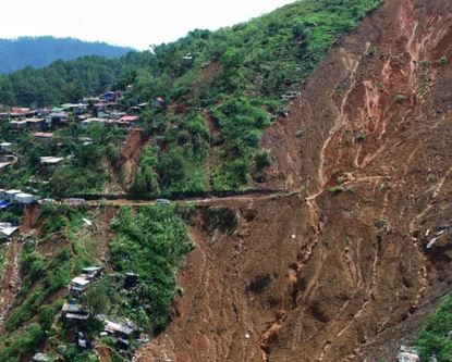
Further detail of the Barangay Ucab landslide in the Philippines. Drone image posted to Twitter by Mohammed Abdiker.
.
The intact section of road suggests deep undercutting of the hillslope, with no apparent slope protection. We have previously seen a failure mechanism in which such road cuts destabilise the upper portion of the slope (NB PDF), which loads the lower portion, triggering large-scale failure that transitions into a flow. To verify this requires further investigation, and there may be other explanations, but it would be a good initial working hypothesis.
Such unplanned road cutting is rampant in mountain areas around the world; it inflicts a huge cost on these communities, and on the environment.
 Dave Petley is the Vice-Chancellor of the University of Hull in the United Kingdom. His blog provides commentary and analysis of landslide events occurring worldwide, including the landslides themselves, latest research, and conferences and meetings.
Hi Dave,
if you take a look at the satellite imagery in Google Earth for this area, landslide activity has been present since 2003 (oldest image available) and probably even before. The Thypoon Manghkut has activated these landslides. Looking at the landscape in the region it has been affected by numerous landslides in the past and the road might be just an additional driver to its instability.
Here the coordinates: 16°23’32.86″N 120°39’54.30″E
Cheers,
Jonas
so much of the tragedy might have been prevented if the Philippines had followed the South Korean example of population control. But no, anti-contraception forces, and we know who they are, ruled the day and the Philippines, in so many ways, are suffering the consequences.
[Eh? This landslide had nothing to do with population control. D.]
The terrain looks as though it is unstable slopes of soft, weathering rock or fine grained sediments with clay, easily mobilized when saturated during monsoons. The need for people to have safe dwellings is contradicted by the numerous land sliding events. This seems to be a rather frightening area to live in because not only does it injure and kill people, but destroys homes and belongings as well as transportation.
OMG! I can’t believe a single landslide can do so much damage.
Totaly agrre!