
9 July 2018
Fagraskógarfjall: a very large landslide in Iceland on Saturday
Posted by Dave Petley
Fagraskógarfjall: a very large landslide in Iceland on Saturday
Early on Saturday morning a large landslide detached from the Fagraskógarfjall massif in western Iceland, near to Hitardal. RUV has a report about this landslide, which it is claimed may be the largest event recorded in Iceland to date (though I doubt that it is larger than the Askja landslide in 2014 in reality). RUV has the following image of the landslide, which gives a good impression of the scale:-
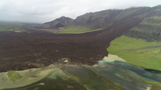
The landslide at Fagraskógarfjall in Iceland. Image via Vilhjálmur Þór Guðmundsson – RÚV.
.
Meanwhile, Iceland Review has a good image of the landslide from another perspective too:
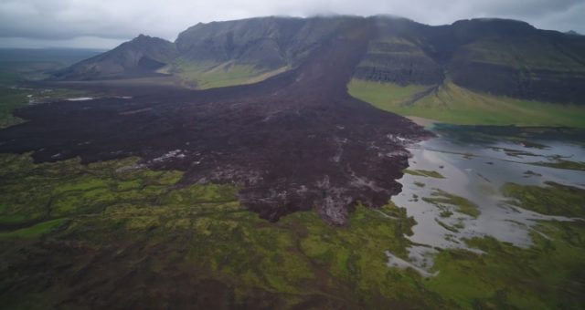
The large landslide at Fagraskógarfjall in Iceland. Image via Iceland Review.
.
There is a good drone video on Visir. The landslide debris reportedly covers an area of about 1.8 km² and a runout distance across the plain of about 1.5 km. There is a news report, also with some good quality drone and helicopter imagery of the landslide, on RUV. It is in Icelandic, but Google Translate does a reasonable job. This is clearly an area that is blessed with a large number of insects. The landslide has blocked the river, and a lake is developing, though it appears that the water will probably find an alternative channel fairly quickly.
Whilst northern Europe is having an exceptional summer (the weather in the UK is the driest in 40 years for example), Iceland is suffering from very poor conditions. May was the wettest on record in Reykjavik, and June was no better, suffering the lowest number of hours of sunshine in June in recorded history. Thus, it seems likely that the landslide was a consequence of the high levels of recent rainfall.
This landslide will have generated a strong seismic signal, but reports suggest that there is no seismic station within 40 km, sadly.
 Dave Petley is the Vice-Chancellor of the University of Hull in the United Kingdom. His blog provides commentary and analysis of landslide events occurring worldwide, including the landslides themselves, latest research, and conferences and meetings.
Any casualties reported?
[No casualties – fortunately this is a sparsely populated area. D.]
Postglacial, geomorphological evidence of landslides must be abundant in Iceland. How many comparable slides are there? And when do they occur? I wonder.
how would you classify this landslide? what type is it?
Here are links on two news pieces on the landslide published by the Icelandic Met Office:
http://en.vedur.is/about-imo/news/a-large-landslide-falls-in-hitardalur-valley
http://en.vedur.is/about-imo/news/displacements-in-fagraskogarfjall-for-some-time-before-the-landslide-fell