
17 November 2017
Detecting landslide precursors from space
Posted by Dave Petley
Detecting landslide precursors from space
A holy grail of landslide studies is the ability to anticipate future behaviour by reliably detecting precursors. This is a highly fraught activity at any level, with the complexity of landslide behaviour rendering the interpretation of patterns of movement challenging. However, in situ detailed monitoring has yielded some interesting results over the years, and efforts continue. Meanwhile, developments in satellite technologies mean that detecting deformation from space is becoming increasingly possible. In particular, the InSAR technique, which uses techniques to compare repeated radar images, is very promising. The latest generation of ESA radar satellites, Sentinel 1A and 1B provide high quality imagery every six days in some cases. Thus, intuitively it feels that there is the potential to use these techniques to detect precursory landslide activity that might indicate that a collapse is likely, providing mechanisms to anticipate failure events and thus make communities safer.
But for this to be possible, it is first necessary to use the archive of images that is now building up to look at the precursory activity for large failures that have occurred. This should start to indicate what might be viable, and what we should be looking at. In a paper just published in the journal Landslides, Intrieri et al. (2017) have examined an archive of 45 satellite images using the InSAR technique for the area that was affected by the 24th June 2017 Maoxian landslide, which killed over 100 people in the village on Xinmo in Sichuan Province. I featured this large landslide at the time. Sentinel 1A and 1B imagery is available for this site from 9th October 2014, with the last image before the collapse being captured on 19 June 2017, five days before the landslide.
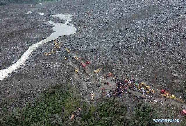
Recovery operations from the Xinmo landslide in China, showing the scale of the challenge. Image via Xinhua
.
The image below, from the paper, shows the deformation map extracted from the images, and provides a plot of three reference points. It is clear that in the source area of the landslide there was an area of active movement over the three years prior to the collapse. The rates of movement were not very high, 40 – 60 mm over a three year year period prior to the acceleration to failure, but the technique is able to resolve them clearly.
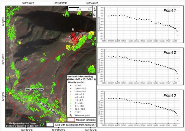
Precursor movement of the Maoxian landslide, from Intrieri et al. (2017)
.
Interestingly, for all three data points there is a marked acceleration in the Spring of 2017, showing that the slope was evolving towards collapse. Intrieri et al. (2017) have been able to extract additional monitoring points from the data for this area of active deformation, which clearly demonstrate this accelerating pattern. As I have noted previously, first time collapses in brittle rocks often show a hyperbolic increase in movement rate (or perhaps seismicity) prior to failure – the so-called Saito effect. The Maoxian landslide shows this as well, according to Intrieri et al. (2017), starting in April 2017.
This is a really important and interesting paper. It demonstrates that InSAR can be used to detect landslide precursors at a scale that is useful, and that the technique can extract the rate of movement to the extent that acceleration to failure can be detected. That opens up the possibility – albeit with a great deal of additional work – of using these new satellite tools as a warning system. That is fundamentally exciting. The study also provides another detailed archive of the actual nature of these precursory movements. And, importantly, it demonstrates how a first time failure develops across a slope.
Reference
Intrieri, E., Raspini, F., Fumagalli, A. et al. 2017. The Maoxian landslide as seen from space: detecting precursors of failure with Sentinel-1 data. Landslides. https://doi.org/10.1007/s10346-017-0915-7
 Dave Petley is the Vice-Chancellor of the University of Hull in the United Kingdom. His blog provides commentary and analysis of landslide events occurring worldwide, including the landslides themselves, latest research, and conferences and meetings.
Fascinating, promising, and …fraught with liability?
The cynic in me can’t help but think of the legal, political, etc. issues associated with natural hazard prediction. The trial, sentencing and yes, the eventual overturning, of the Italian scientists’ manslaughter conviction comes to mind.
Big data, big planet with an unequal distribution of resources, and probabilities…seems like a perfect use for the emerging AI technology.
Huge, ancient earth flows, maybe as the one represented in the figure, often reactivate starting from the crown and then propagating toward the foot. In this case the PS InSAR can help to predict the reactivation. But in my experience, in Italy, this method can give also false alarms. Its reliability depends from several factors, as the azimuth of the slope movement in relation to the the path-orbit of the satellite (N-S ground movements may be not detected). Despite all this, the method is very promising and we use these data almost on a daily basis for territorial planning and risk evaluation. But ever in comparison with other methods: i.e. Inclinometers.