22 December 2015
The Shenzhen, Guangdong landslide: a massive flowslide in construction waste
Posted by Dave Petley
The Shenzhen, Guangdong landslide: a massive flowslide in construction waste
The well-reported, enormous landslide in Shenzhen earlier this week was a most interesting, and of course deeply tragic, event. It is now clear that the Guangdong landslide was a very large flowslide from a pile of construction waste in a quarry above the industrial estate. Some reports suggest that there was heavy rainfall at the time. The Chinese news agency Xinhua has the best images of the landslide that I have seen to date, including this one showing the landslide mass and a part of the source in the background:-
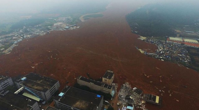
The Shenzhen, Guangdong landslide in China. Image from Xinhua,
.
As of this morning the number of people reported missing in the landslide is 85, with just one body recovered. There can be little hope of any survivors now. Xinhua reports that the landslide has covered an area of 380,000 square metres to a depth of 10 metres, giving a volume of 3.8 million cubic metres. This is an unusually large man-made slide. In essence the event appears to be almost identical in mechanism and outcome to a mine waste flowslide, of which China has had many of course. The best recent example is probably the Hpakant flowslide in Burma a couple of weeks ago, which also had a tragic outcome.
Of course in addition to the rescue operations, the focus is on how this can have happened. The International Business Times has a nice article that outlines the situation as of yesterday:
Residents told Xinhua the Hongao Construction Waste Dump had built up for nearly two years and stood at nearly 20 stories high when it collapsed. It also had overly steep slopes, making it unstable, the Ministry of Land and Natural Resources said. Documents published on the Guangming New District website showed officials had conducted monthly inspections of the dump, the South China Morning Post reported. In February 2014, officials gave the dump approval to operate for just 12 more months, but found in July — five months after it should have closed — that it was still in operation. At that time, the site was not following agreed safety or maintenance plans. Officials told the dump managers to improve its conditions and reapply for a license by September, which it also failed to do, according to the documents. “Illegal dumping of earth is strictly forbidden,” a statement in the documents said, according to the South China Morning Post.
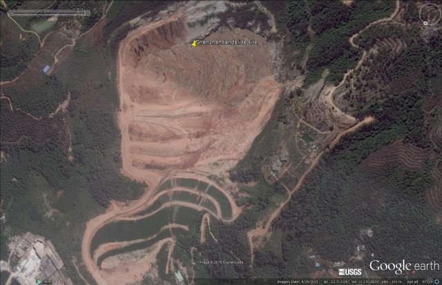
The location of the landslide is 22.718, 113.933. There is excellent Google Earth imagery of the site. The most recent image of the quarry, taken on 29th September 2015, shows a large amount of dumped construction waste in the pit, retained by very steep, benched slopes:
.
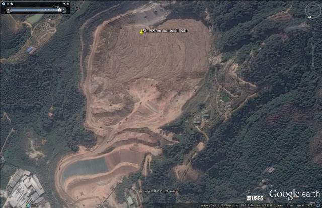
This was quite literally a disaster waiting to happen, and there can be no excuse for this. Zooming back a year, this was the site on 23rd November 2014:
.
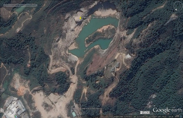
Note the extensive work going on around the lower slopes. There are large numbers of dumper trucks hauling waste in this area. But a year earlier the site looks quite different. On 25th November 2013 the site was an abandoned, flooded quarry with no haul roads and no waste:-
.
It is notable that there is very little drainage evident in the debris pile in the most recent images. I suspect that a key part of the investigation may well be to ascertain what measures were in place to prevent the build up of excess pore water pressures in the spoil. The presence of water in the quarry before the dumping began suggests that the natural drainage through the bedrock was probably limited.
I would also draw your attention to one aspect of the most recent image that is not obvious at first inspection. The image is a composite, with the join running through the quarry. The more recent image is the lower portion – note the change in colour balance. I have drawn a line below to show the approximate location of the joint between the two images:
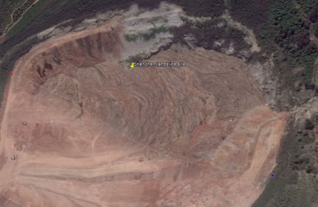
The most recent Google Earth image of the Guangdong landslide. The lower portion of this image is more recent, the line marks the point at which the two images are stitched
.
The lower (newer) portion of the image suggests that there was a new phase of dumping occurring on the waste at the very top of the slope, in effect to infill the remainder of the quarry. This will have steepened the waste pile dramatically, and may be the reason why the failure occurred now, rather than in the wet season.
I will post again tomorrow with a compilation of the amazing videos of the landslide event.


 Dave Petley is the Vice-Chancellor of the University of Hull in the United Kingdom. His blog provides commentary and analysis of landslide events occurring worldwide, including the landslides themselves, latest research, and conferences and meetings.
This is a sad event because it was predictable and preventable. People in the USA complain about government regulations, but this is what happens when a country does not have good regulations and does not enforce them.
The landslide occurred at around 11:40am on Sunday (local time) in the Hengtaiyu industrial park in northwestern Shenzhen’s Guangming New District.
Shenzhen Weather could be found at website of Meteorological Bureau of Shenzhen Municipality
Daily Rainfall (note that daily records may not end/start at midnight local time) at Shenzhen’s Guangming New District extracted as follows:
18/12/2015 0 mm
19/12/2015 0 mm
20/12/2015 0.5 mm
21/12/2015 3.4 mm
I agree with mark – Never had to happen.
Looks like several years of uncontrolled dumping on the uppermost east perimeter of the old pit. Well-developed flow-banding in the deposits indicates many failure events. Recent grading appears to be window-dressing on the downhill side.
“but this is what happens when a country does not have good regulations and does not enforce them.” The earth is gradually changing as all the people on earth have unconscious lifestyles that make the atmosphere worse. The government cannot control it all.