
11 September 2010
Pakistan floods – the extraordinary duration of the elevated water levels
Posted by Dave Petley
The floods in Pakistan may have faded from the headlines in Europe, but unfortunately the impact continues, even though the rainfall events that caused them occurred more than a month ago. The most dramatic illustration of this is a set of satellite images collected by NASA using the MODIS instrument.
This is an image of the area around Sukkur taken on 7th July, before the rainfall event that initiated the disaster:

By way of comparison, this image was taken on 7th September, showing the same area:
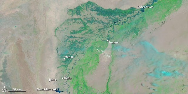
Two things to note. First the extensive flooding along the line of the main part of the Indus remains. This may well be an indication that water is draining very slowly from behind the broken levees, which are now serving to keep water in despite their failure to keep the water out in the initial event. Such problems with broken levees are common. Second, note the parallel course of the Indus that has been created, where the flooding is much more intense. I assume that this is the river occupying one of its old drainage paths. The problem here may be that the downstream end of this huge (check out the scale bar on the imagery) new watercourse is Mancchar Lake. This is an artificial lake, created in the 1930s, with a range of existing environmental problems. The lake appears to be connected to the main Indus River by just two small canals (see Google Earth image below):

This limited drainage path is may cause the floods to drain very slowly, prolonging the agony for those affected. The flood waters must now be highly polluted, increasing the potential for health problems for the affected population.
 Dave Petley is the Vice-Chancellor of the University of Hull in the United Kingdom. His blog provides commentary and analysis of landslide events occurring worldwide, including the landslides themselves, latest research, and conferences and meetings.
Please read this article and comment.[The flood is now over a month old and has yet to debouche into the Arabian Sea. Rather it continues to move at a snail’s pace whilst challenging the Southern areas of Pakistan, intercepting highways, inundating oil/gas fields and naval garrisons. Now as more rains fall in upper Pakistan and Kirthar Range, the menace will prolong miseries inasmuch as the political spinoffs of poverty.For quite some time the water levels at Guddu and Sukker Barrage were over 1,000,000 cusecs. The arrival at Kotri was much below expected. Despite the havoc it has now wreaked in Thatta, Sajawal and Johi, the discharge still does not match the initial thrust at the two major barrages upstream. This means that the flows recorded at the two barrages were minus the diverted flows that hit Balochistan and Upper Sindh. Where has all this water gone and when will it recede is a big concern?The entire Dera Allah Yar, Manchar, Juhi Complex overhangs like a daemon that will take its toll before the exorcism is complete incurring socio economic and political scars for a long time to come.]http://insight-and-foresight.blogspot.com/2010/09/pakistans-flood-darning-shreds.html