
10 September 2010
Ruapehu lahar information
Posted by Dave Petley
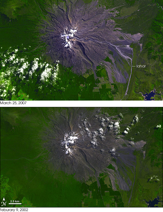
One of the many highlights of the splendid IAEG Congress in Auckland this week was a talk by GNS geologist Chris Massey on the 18th March 2007 lahar at Mount Ruapehu on North Island. The lahar occurred as a result of the failure of a tephra wall holding back the crater lake at the summit, and is shown by this NASA image:
The potential for a lahar had been anticipated and the site was intensively monitored with real time instruments such as water level sensors and geophones; with two web cams; and with periodic surveys using a terrestrial laser scanner. An emergency plan was in place and worked well. The need for caution was undeniable – on 24th December 1954 a lahar from the same site demolished a railway bridge at Tangiwai, killing 151 people on a train that tried to cross a bridge that had been destroyed by the lahar.
The event has been written up in a paper (Massey et al. 2010), and there is a spectacular set of images of the event captured by the web cam available here (NB it took me a while to get my eye into these images).
An interesting aspect of this event is that one can examine just how good the natural hazard science community is at assessing hazard. There is a New Zealand Civil Defence report, written in 2002, about the threat of a lahar at Ruapehu online here.
Reference
Massey, C., Manville, V., Hancox, G., Keys, H., Lawrence, C., and McSaveney, M. 2010. Out-burst flood (lahar) triggered by retrogressive landsliding, 18 March 2007 at Mt Ruapehu, New Zealand—a successful early warning. Landslides 7 (3),303-315, DOI: 10.1007/s10346-009-0180-5.
 Dave Petley is the Vice-Chancellor of the University of Hull in the United Kingdom. His blog provides commentary and analysis of landslide events occurring worldwide, including the landslides themselves, latest research, and conferences and meetings.