
9 January 2010
The 2009 fatal landslide map and statistics
Posted by Dave Petley
This post presents the data from the Durham University Fatal Landslide database for 2009. First, this is the map of fatal landslides. Each red dot represents a single landslide recorded on the database. Click on the map for a better view in a new window:
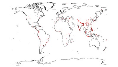
The map shows the usual distribution. Note the high incidence of landslides in SW India, the Philippines and in java in Indonesia. The high occurrence of landslides along the southern margin of the Himalayan mountain chain is also clear, but is less continuous than usual. This reflects the 2009 monsoon rainfall pattern, which was substantially below average, especially in the northwest of India, as the map below (for India only), from Monsoon Online, shows. The map indicates the departure from the mean annual monsoon rainfall:
 In terms of statistics, the key data are:
- Number of recorded fatal landslides: 493 (this is substantially above the long term average).
- Number of recorded fatalities: 3611 (this is substantially below the long term average, primarily because there were no large earthquakes in populated mountainous areas).
 Dave Petley is the Vice-Chancellor of the University of Hull in the United Kingdom. His blog provides commentary and analysis of landslide events occurring worldwide, including the landslides themselves, latest research, and conferences and meetings.
Hello, Is there any chance to get more datail information about this database? I'm working with landslades in Colombia and it will very helpfull if I updated my information. Thanks
VanessaCould you drop me a line on [email protected] ThanksDave