
5 September 2008
Hurricane landslides in Haiti
Posted by Dave Petley
A perennial landslide story at this time of year is the triggering by a tropical cyclone of landslides in Haiti. This year the hurricane season has been particularly cruel, with three large events in a month. Hanna, the most recent, appears to have stalled close to Haiti for a day or so, causing torrential rainfall. At the moment reports suggest that 136 people have been killed in flash floods and landslides as a result of Hanna, but that figure may well rise as the picture becomes clearer. Unfortunately, there is another, very intense “Cape Verde” type hurricane (called Ike) lurking to the east. Current forecasts suggest that the track will swing north of Haiti (in fact Florida could get a direct hit), but at this stage such forecasts are at best tentative. A direct hit from a hurricane as large and intense as this, on the back of Hanna, could be disastrous for Haiti.
So why is Haiti so vulnerable to hurricanes? Basically, Haiti is the most extreme illustration of the impact of deforestation on landslides and flash floods. Haiti is the poorest country in the Caribbean – over half the population live on less that $1 per day ($1 is the recognised mark of extreme poverty) and over 75% live on less that $2. More that 60% of the working population do not have formal employment. The consequence of this has been extreme deforestation, primarily for firewood to create charcoal.
This is rather well illustrated by this Google Earth image:
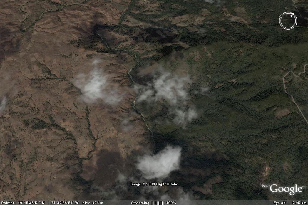 The border between Haiti and the Dominican Republic is the river that runs across the centre of the image. On the west (leftish) side is Haiti, to the east (right) is the Dominican Republic. The contrast between the two is striking – in the Dominican Republic deforestation has been limited, in Haiti the loss of forest is almost total.
The result is that during hurricanes the landscape has little capacity to intercept and store water, and once flows across the surface begin the landscape rapidly erodes. This is perhaps best illustrated by the following Google Earth image of the city of Gonaives in the east of the country. Gonaives has been very seriously affected by erosion and landslides again in the most recent floods. The image shows the hills on the outskirts of the edge, with the suburbs clearly visible. The hills are clearly suffering from extreme deforestation. In September 2004, Hurricane Jeanne triggered mudslides and debris flows from these hills that killed over 3000 people in the city. Bearing in mind the fact that Haiti should be densely vegetated with tropical forest, the disaster that is the landscape in this country is all to clear to see. Unfortunately, posts about landslide disasters in Haiti will be a feature of this blog in the late summer for years to come.
 Dave Petley is the Vice-Chancellor of the University of Hull in the United Kingdom. His blog provides commentary and analysis of landslide events occurring worldwide, including the landslides themselves, latest research, and conferences and meetings.
[…] to the rampant deforestation there. That deforestation is an issue in Haiti is beyond doubt – indeed I have blogged on this previously. I am certainly not the first to note that the border between the Dominican Republic (to the east […]
[…] I blogged about the vulnerability of Haiti to hurricane rainfall right back in 2008. I wrote: […]