
4 June 2008
Updated: Tangjiashan (Beichuan) dam – a summary of what we know
Posted by Dave Petley
In the next 24-48 hours the water level at Tangjiashan should reach the spillway and flow should start. I thought therefore that it would be useful to summarise what we know about the site:
- The landslide dam is 124 metres high;
- At the time that the over topping begins the lake will have a volume of about 205 million cubic metres of water (UPDATED – the volume is now estimates as 211.6 million cubic metres as at 2 pm (loca) Wednesday. The lake level had 1.37 m to go before reaching the spillway)
- The channel that has been cut appears to be about 5 (now known to be 7 m) wide at the bed (though note that the film with the journalist in the bed suggested less than this) and about 15 m at the top. It is 12 m deep The bed is unlined and unprotected. It is formed in silty materials with a few clasts (stones);
- Failure can occur through any of three mechanisms:
- The water can reach the spillway and start to flow over the dam;
- The two known seepage points (total reported flow = 10 cubic metres per second) in the dam could cause collapse;
- A landslide into the lake could trigger a wave that would overtop the dam. A dangerous slope has been identified at Xuanping township.
- Downstream there are three further (smaller) landslide dams in the Beichuan area;
- The Chinese government has relocated about 250,000 people. In total, about 1.3 million would be threatened by total collapse.
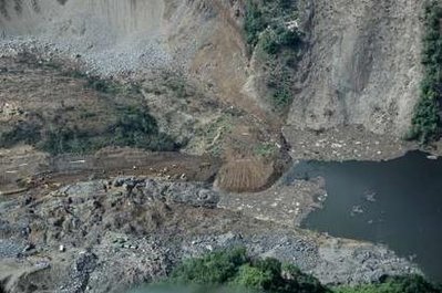 Reuters image of the top of the dam showing the lake and the spillway under construction
These are the best and worst case scenarios for the dam as I see them:
Best case: water flows over the spillway and erodes it slowly. The lake level reduces gradually over a few weeks;
Worst case: a large landslide into the lake triggers a wave that overtops the dam, causing complete collapse. The entire volume of the lake is released very rapidly. The resultant flood pools behind and then breaks through the downstream dams, creating a devastating debris flow.
The most likely scenario at this stage is that water will flow over the spillway. A ball park flow rate appears to be about 100 cubic metres per second when there is no rainfall. This channel will not be able to cope with this as far as I can see, leading to rapid erosion and therefore collapse of the dam. I suspect that most of the lake volume will be released in a few days at most. The water is likely to pool briefly behind the landslide dams downstream, which will probably increase the size of the flood wave once released.
Where will the water go? I have tried to produce a quick Google Earth summary image below of the anticipated flow path (click on the image for a better view):-

The flood is likely to be large, fast and very damaging in the mountains, but should spread at least a little and slow on the plains. We can only hope for the best.
I am travelling to Nepal this afternoon, but will do what I can to keep this updated from there.
 Dave Petley is the Vice-Chancellor of the University of Hull in the United Kingdom. His blog provides commentary and analysis of landslide events occurring worldwide, including the landslides themselves, latest research, and conferences and meetings.
You have a very good website with lots of information, I like it very much. Keep up the good work!!! You can blog in the language of your country to read if you Google Language Tools germany> Their language at home the link http://www.rentner-haben-keine-zeit.dePlease read by clicking the Google ads.
Dear Prof Dave,The water level had risen to 738.5m by 8 a.m. on Thursday and just 1.5m below the channel level. Probably, the lake will overtop within next 24 hours with best case as you explained. The worst case can not be ignored because of:- large seepage discharge,- potential landslide in the upstream of the lake,- continuous aftershocks- forecasted rainfall- instability of the dam body