
8 August 2023
Three new videos from Montana
I spent several enjoyable weeks in Montana last month, and shot some new video content there for my YouTube channel. Here are three videos that may be of interest to readers of this blog:
5 August 2023
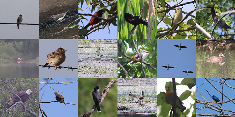
Bird update “July” 2023
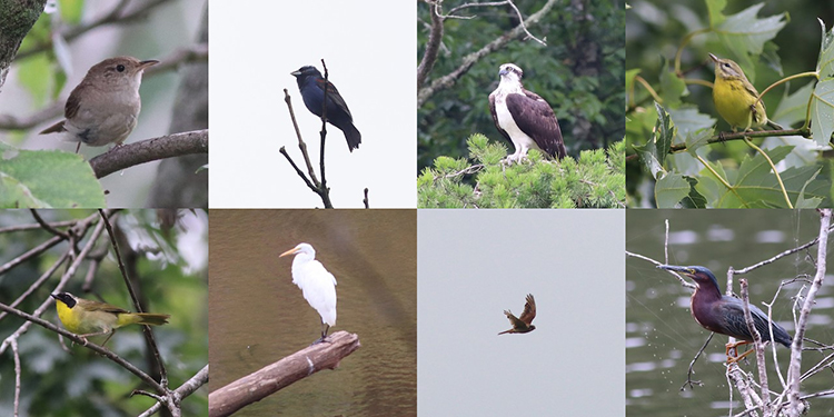
Oops – July slipped by without a monthly bird update!
Maybe that’s not the end of the world – I spent much of the month in Montana, and only tacked a few new species onto my county list – a Swallow-tailed kite, a Northern bobwhite, and a Great egret (photo above, 2nd column in the 2nd row). So for those keeping track, that puts me at 154, which is ranked 4th in my county (so no change there).
I’m still missing a few species which should be low-hanging fruit, but somehow they keep eluding me. Next week is my last week of summer break leisure before pre-semester meetings start up again, so maybe I can harvest a few more sightings before I have to go back to work.
28 July 2023
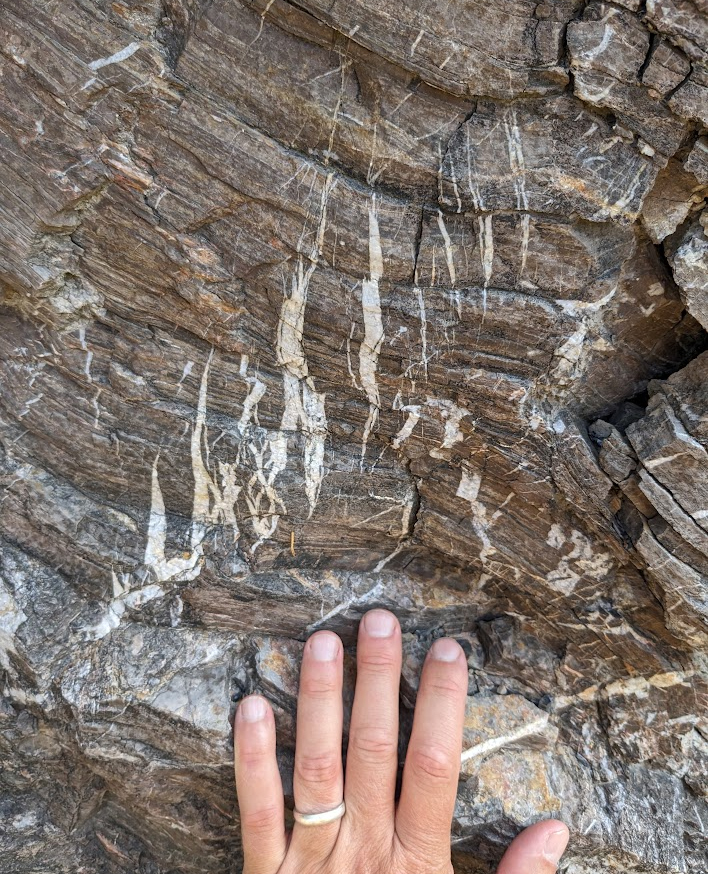
Friday fold/fauxld duet from Glacier National Park
Here are a couple of the scenes I was lucky to view last week in Montana’s Glacier National Park:
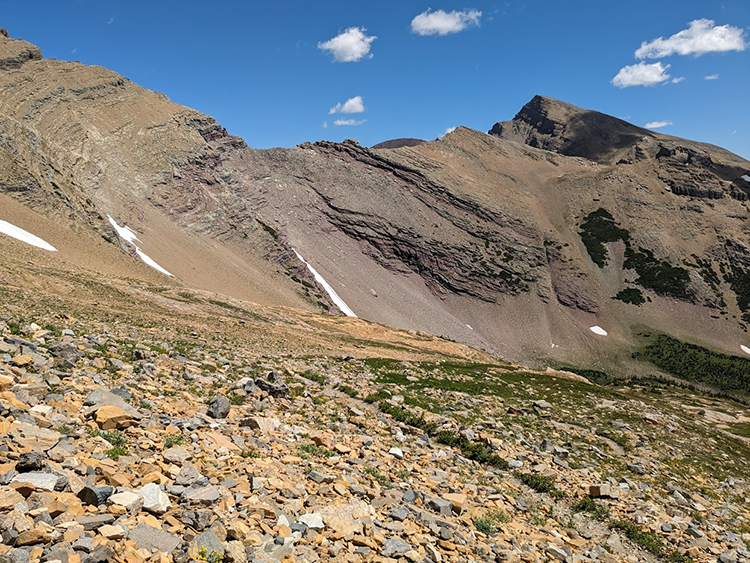
I like how these two scenes compare and contrast with one another. One shows an anticline; the other a false anticline.
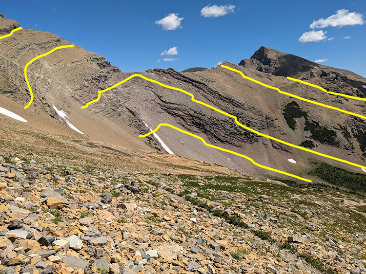
Let’s deal with the faker first: the first image is a scene on the Siyeh Pass trail, which shows almost uniformly dipping strata of the Empire Formation (there are a couple of kink bands). The appearance of a “fold” comes from the varying orientation of the trace of those beds, determined by the orientation of the outcrop surface. Here, a big scoop has been taken out of the mountain by a tributary glacier, and that causes the trace of bedding (yellow, in the annotated copy below) to varying on the cirque’s south, west, and north sides. I’ve highlighted similar “false folds” previously, as with this example from Death Valley.
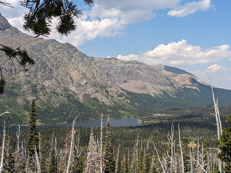
In contrast, at Two Medicine, an actual anticline is bisected by a valley between Rising Wolf Mountain (left/west) and Spot Mountain (right/east):
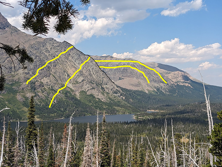
This is right on the (eastern) leading edge of the Lewis Thrust sheet, and there’s a lot of deformation there, both in terms of folding of various styles and wavelengths, but also subsidiary thrust faults.
I really love leading this “Geology of Glacier National Park” field course for science teachers every summer; it’s a highlight of my year.
14 July 2023
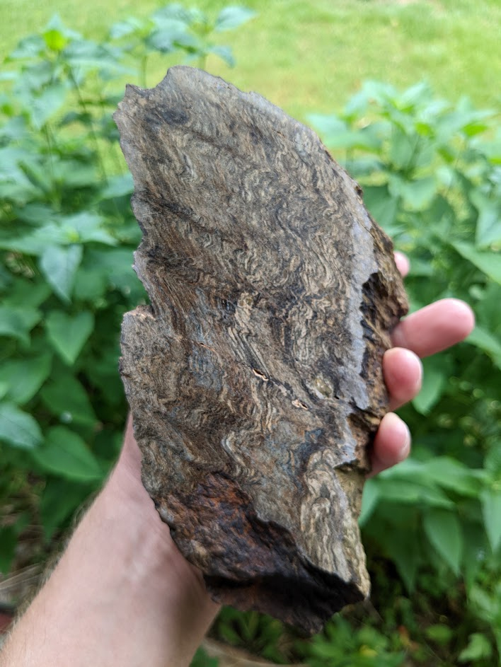
Friday fauxld: Sacagawea Cirque
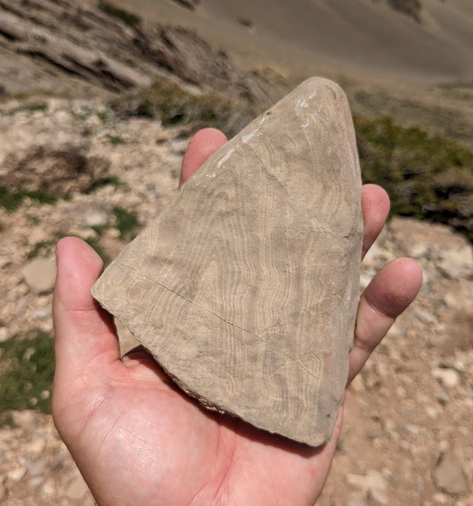
Found this beautiful cobble while hiking Sacagawea Peak with my family yesterday, in Montana’s Bridger Range. It’s not actually folded as much as it appears to be; the laminations are slab like and nearly parallel to the surface in this photo, with the cobble surface sectioning them obliquely to produce this pattern.
30 June 2023
Friday fold: Wissahickon block
Click to enlarge

I’m writing this on the Amtrak train from New York back to Charlottesville, traveling (again) under orange-hazy skies due to Canadian wildfire smoke. I took my son to Manhattan for a concert, and we stopped off en route for an overnight in Philadelphia, visiting a former student of mine who’s now an assistant professor of geology at Rowan University in New Jersey. While walking around Philly, I saw an old church that had been built from blocks of locally-quarried Wissahickon Formation schist. This particular block shows some nice small-scale folds in both the foliation (subtle, at right) and a trio of quartz veins (more obvious, center).
Also, in another block of the same formation in the same church wall, I saw this lovely little garnet porphyroblast bearing pressure-shadow “beards” of quartz that have grown out along the plane of foliation:
29 June 2023
Bird update June 2023
Click to enlarge

A brief update here, since it’s getting close to the end of the month. I’ve added a half dozen species to my county list since I last reported out to you all. I’m up to 151 for the county for the year. This means that I’m still ranked in the top ten, but I’ve slipped to #4. I’m helping to lead a public-facing birding walk on Saturday at Ivy Creek Natural Area, so that might mean I get one or two more. I’m still missing Purple Martin, Whippoorwill, and Bobwhite quail. Notably, I did get a rare Roseate spoonbill last week, though!
12 June 2023
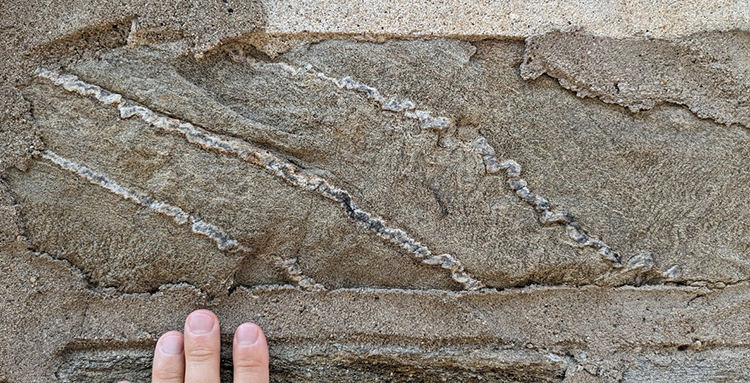
Tension gashes in the Tonoloway Formation
I spent yesterday on Corridor H in eastern West Virginia’s Valley & Ridge province. The rocks here are a mid- to upper-Paleozoic set of strata that record the switch from post-Taconian passive margin sedimentation into Acadian clastic deposition, and then everything is deformed by Alleghanian folding and thrusting. I found myself taking photographs of the same old outcrops I know and love there – but here’s something new that I don’t think I’ve reported previously: a lovely set of tension gashes disrupting well laminated dolostones of the (Silurian-aged) Tonoloway Formation.
It’s a decent en echelon array of these short extensional veins, but then bedding-perpendicular compression resulted in the development of stylolites that cut across the veins, and make them appear “offset” in places – but not due to bedding-parallel slip, merely dissolution of material that once used to connect as-yet-undissolved sections of vein.
9 June 2023
Friday fold: Pleasant Grove Park
Happy Friday, friends.
Here’s a rock sample that I recently polished up:
It shows crenulations in “pinstriped” schist of the western Piedmont in Pleasant Grove Park in Fluvanna County, mapped as the Mine Run Complex. Lovely stuff, eh?
7 June 2023
Seeing spots thanks to Canadian wildfires
Sunset last night was fairly apocalyptic.
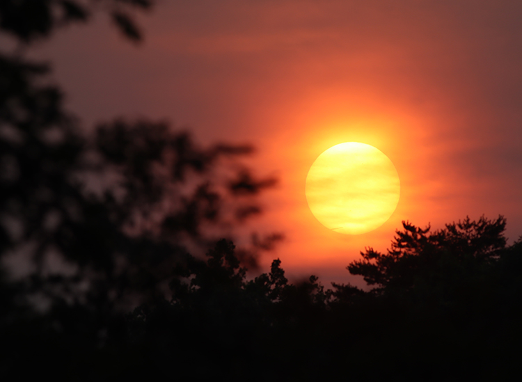
The rich orange color – fiery, one might say – is quite striking. In fact, all day long, the quality of the sunlight had been strikingly diffuse and orange-tinted. But sunset really brought out the color.
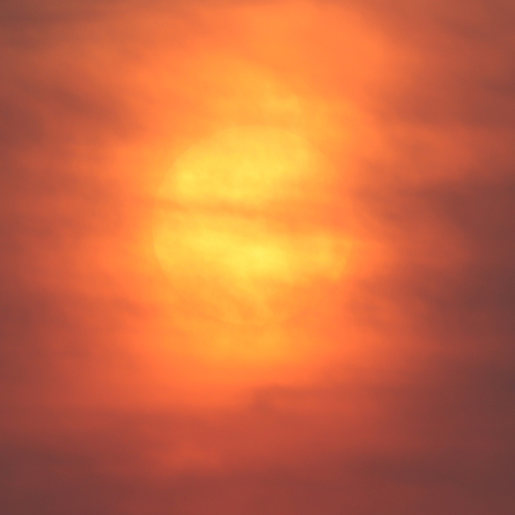
This unusual circumstance is due to a very heavy atmospheric load of particulates, shockingly coming from the other side of the continent. Wildfires burning in Canada are generating prodigious volumes of smoke, and these are being trundled along on enormous currents in the troposphere in a big arc that brings them southward over the east coast of the United States. The air quality index has dropped precipitously, particularly in large cities. Furthermore, the smoke has made daylight uncanny and imbued the landscape with a sense of ominous foreboding.
Here’s a screenshot from this morning’s AirNow fire and smoke map:
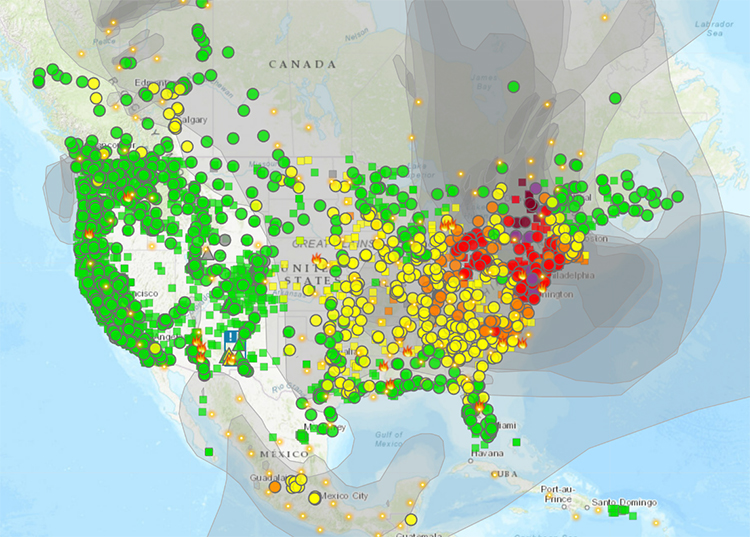
AirNow.gov
But there’s a bright side to this situation, and that’s this:
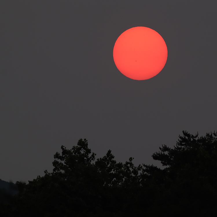
That is a photo I took the night before last, about 15 minutes prior to sunset, when the haze wasn’t quite as obscuring, and essentially acted like a giant “filter” so I could photograph the Sun with my normal camera in my front yard. What shocked me about that photo is that when you zoom in, you can actually make out sunspots!
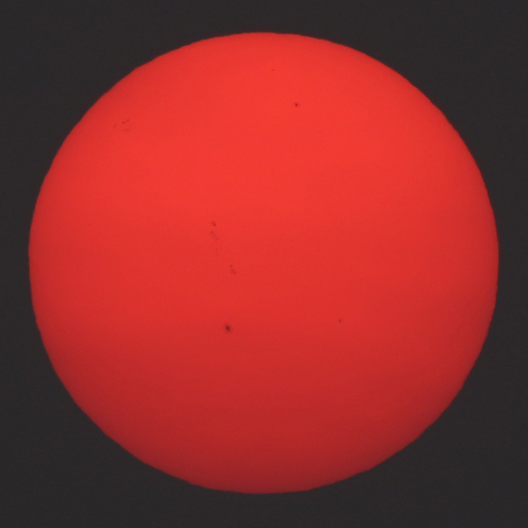
I was darned near gobsmacked to realize that I was imaging sunspots without any special equipment from a few steps beyond my front door. These are not just dirty spots on my lens or CCD – I checked the sunspot map for the day at Space Weather Live, and sure enough, the pattern matched:
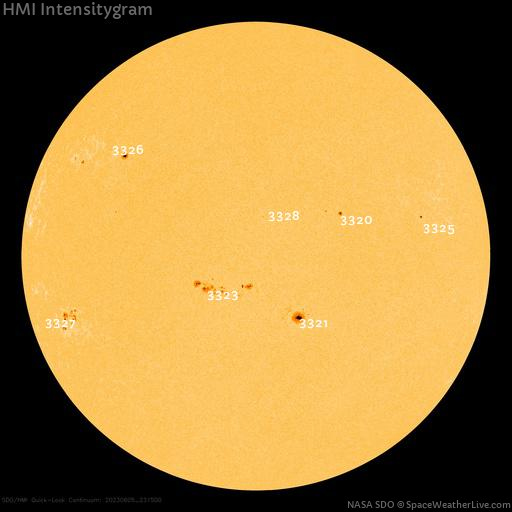
Looks like it’s rotated 90° relative to the Sun’s orientation as I photographed it, but that’s definitely the same pattern – and that’s just so cool.
Though the wildfire smoke is horrible on many levels, it did grant me this special view of the surface of my local star, and I feel privileged for that glimpse.
————————–
Of course, you should be extremely careful in any solar observations. Don’t burn your eyes out by looking directly at the Sun without the benefit of several tens of cubic kilometers of intensely smoke-laden atmosphere to act as a filter!
The unconformity gets its portrait taken
I’ve been helping a student of mine work on a mapping project these past few weeks, documenting the geology in Pleasant Grove Park in Fluvanna County. That’s in Virginia’s Piedmont geologic province, a land of rolling hills where we find the remains of the Iapetus Ocean basin, thence squashed and cooked at the roots of the young Appalachian Mountains. Pleasant Grove Park is an interesting place with lots of trails which supposedly hosts a contact between Laurentian-affinity and peri-Gondwanan terranes. Exposure isn’t all we could hope for, but there are some neat outcrops for sure.
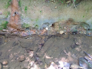
Here’s one outcrop that I thought to be fairly impressive when I first walked up to it several weeks ago:

To my eye as a geologist of some vintage and experience, it was plain that I was looking at an unconformity surface exposed in this creek’s cut bank. But I soon realized that not everyone could make that out so plainly. I took the photo above and then posted it to the PVCC Geology Club’s Discord server, where I post daily challenges for my students. My expectation was that someone would be very quick to key into the difference between the exposures in the stream floor and those of the cut bank above, marked by a layer of gravel along the contact.
But that didn’t happen. There was an excruciating series of guesses and frustration as I said “nope” over and over. The students got the cut bank part, but they didn’t get that it was an unconformity until I drew in some lines annotating the photo.
I realized that I hadn’t set them up for success, because I took a pretty crummy photo of the outcrop.
Yesterday, back in the park, I resolved to do better. This time, before I took the photograph, I (a) positioned a sense of scale, (b) cleaned the bedload cobbles off the stream floor and swished away much of the sand and mud covering the trace of the metamorphic foliation, (c) removed stray vines and other vegetation from the outcrop, and (d) waited for diffuse light, eliminating the inconsistent exposure that comes from the dappled sunlight making its way through holes in the forest canopy. I also (e) changed the angle of capture to more fully capture the “pavement” exposure in the creek bed, with its prominent “diagonal” pattern of the trace of foliation.
This is the result:
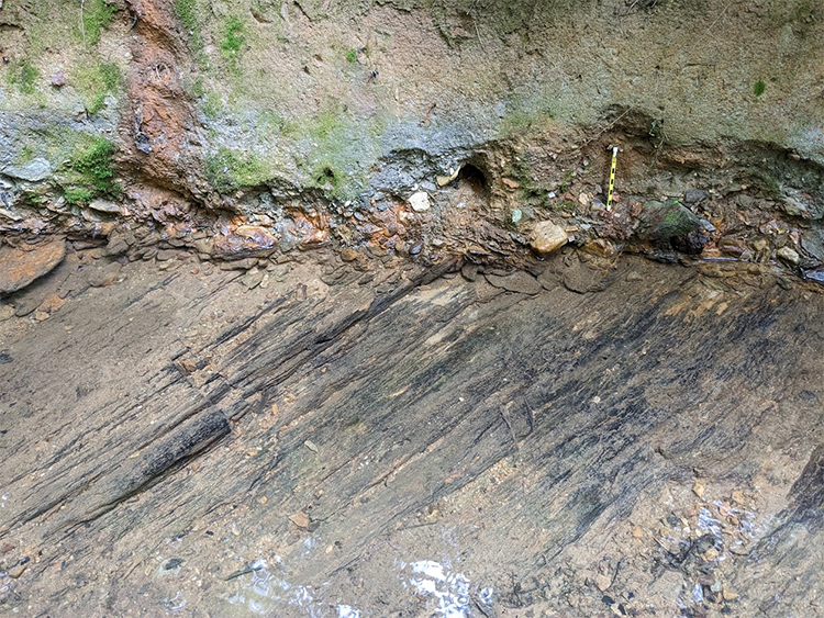
A side-by-side comparison:

I think the key relationship is much plainer in the new image.
So much for my little discourse on outcrop portraiture!
 Callan Bentley is Associate Professor of Geology at Piedmont Virginia Community College in Charlottesville, Virginia. He is a Fellow of the Geological Society of America. For his work on this blog, the National Association of Geoscience Teachers recognized him with the James Shea Award. He has also won the Outstanding Faculty Award from the State Council on Higher Education in Virginia, and the Biggs Award for Excellence in Geoscience Teaching from the Geoscience Education Division of the Geological Society of America. In previous years, Callan served as a contributing editor at EARTH magazine, President of the Geological Society of Washington and President the Geo2YC division of NAGT.