15 March 2019
Landslides induced by the 2010 Chile megathrust earthquake – my new paper
Posted by Dave Petley
Landslides induced by the 2010 Chile megathrust earthquake – my new paper
On 27 February 2010 a huge earthquake occurred off the coast of Chile. With a magnitude of Mw=8.8, the 2010 Chile megathrust earthquake (also known as the Maule earthquake) was the sixth largest event in the instrument record, rupturing a section of fault 450 km from north to south and 150 km from east to west, and with a hypocentre depth of 37 km. This giant earthquake induced ground shaking across a large swathe of southern Chile, killing about 55o people and inducing financial losses in the order of US$4 – 7 billion.
This earthquake provided a perfect opportunity to examine landslides triggered by a large subduction earthquake; at present there are few such events in the global catalogues. So, as part of the Newton Fund project for which I was Principal Investigator, working with colleagues from the University of Chile, the University of Leeds and the University of Durham, we constructed an inventory of landslides triggered by this earthquake. The results have just been published in the journal Landslides (Serey et al. 2019).
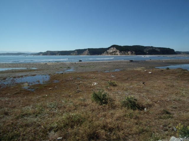
The results are quite surprising. We were able to map just 1226 landslides in total, with a combined volume of just 10.56 million cubic metres. The coastal landslides pictured below, in the Arauco area, are examples of mass movement events triggered by the earthquake:-

Coastal landslides triggered by the 2010 Chile Megathrust earthquake
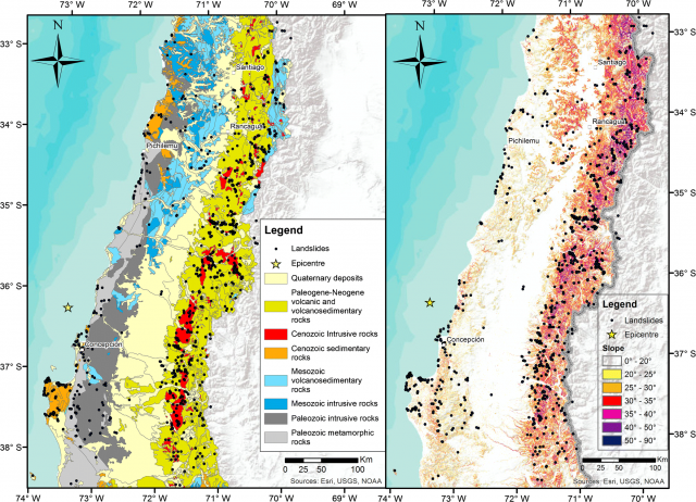
The maps below, from the paper, show the landslide distribution from the 2010 Chile megathrust earthquake:-

The landslide distribution from the 2010 Chile megathrust earthquake, compared to the bedrock geology (left) and slope angle (right). Image from Serey et al. (2019).
.
The landslide distribution extends throughout the area affected by intense ground shaking, but there are clear clusters. The majority of the landslides are located in the Principal Andean Cordillera (the area of higher slope angles inland) and a constrained region near the coast on the Arauco Peninsula in the southwest corner of the map. There is a strong control on landslide occurrence from both geology and slope angle, which is unsurprising. Less expected was the seismic parameter that best correlates with the landslide distribution. This is commonly expected to be peak ground acceleration, but in this earthquake we found that the ratio of horizontal and vertical peak ground accelerations appeared to be the key control.
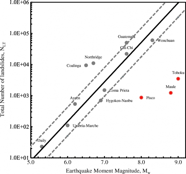
I think though that the most important observation is in the number of landslides triggered by subduction zone earthquakes when compared with the inventories for other large seismic events. The graph below shows the total number of landslides plotted against the earthquake moment magnitude for a number of recent, large events with high quality inventories. Note that the y-axis is plotted on a log scale:-

The relationship between the number of landslides and the earthquake magnitude for a number of large events, including the 2010 Chile megathrust earthquake. Figure from Serey et al. (2019).
.
The three red dots are the large subduction events. It is clear that all three generated very low numbers of landslides compared with other types of earthquakes. Whilst this is probably partly because of the availability of topography (a large part of the rupture occurs under the sea), this does not explain the low landslide numbers adequately. Serey et al. (2019) suggest that:-
“Earthquakes that generate fault rupture at the surface are likely to produce greater amounts of surface waves, which typically is what causes damage. We can speculate that a megathrust earthquake suffers much higher surface wave attenuation than shallow crustal earthquakes, triggering a smaller amount of landslides.”
Reference
Serey, A., Piñero-Feliciangeli, L., Sepúlveda, S.A. Poblete, F., Petley, D.N. and Murphy, W. 2019. Landslides induced by the 2010 Chile megathrust earthquake: a comprehensive inventory and correlations with geological and seismic factors. Landslides. https://doi.org/10.1007/s10346-019-01150-6
Acknowledgement
This work is supported by the RCUK-Conicyt Newton Fund International Cooperation Programme Project NE/N000315/1 “Seismically-induced landslides in Chile: New tools for hazard assessment and disaster prevention” and Fondecyt project 1140317.


 Dave Petley is the Vice-Chancellor of the University of Hull in the United Kingdom. His blog provides commentary and analysis of landslide events occurring worldwide, including the landslides themselves, latest research, and conferences and meetings.
“ratio of horizontal and vertical peak ground accelerations appeared to be the key control.” Is it possible that this is a kind of interference / superposition of the seismic waves?
Did these landslides trigger tsunamis in addition to the larger one they had? And how far did these travel? How many sq km were the landslides? Do you have any information? I am assuming they were more than likely localized. Thank you!
Wow! Thank you for this! I love your website! It us super informative!