
21 June 2016
Kumamoto earthquake: post-seismic landslides kill at least three, two missing
Posted by Dave Petley
Kumamoto earthquake: post-seismic landslides
One of the most serious concerns about the Kumamoto earthquake in Japan was that the timing, shortly before the rainy season, meant that there was high potential for post-seismic landslides. These have frequently proven to be problematic – in essence the first exceptional rainfall after the earthquake tends to drive a spike in landslide activity, with potentially disastrous effects. In the Kumamoto earthquake large numbers of slopes were left in a fragile state. Yesterday, heavy rainfall across the prefecture triggered extensive landslides and flooding. The Asahi Shimbun has a summary of known losses so far:
- In Kamiamakusa a 92-year-old man was killed in his house by a landslide.
- In Uto two houses were buried, leaving one man dead and a woman missing.
- In Kumamoto city two people were trapped by a landslide in their home. One has been confirmed dead, the other is missing
There was also a flood-related death – a 79-year-old man who fell into a drainage ditch and drowned in Kosa.
The Japan Meteorological Agency provides a real time landslide risk map. This is how it looked yesterday (via Robert Speta and Twitter):-
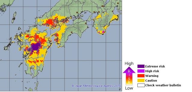
Kumamoto earthquake – landslide risk map for 20th June from the Japan Meteorological Agency
.
And again this morning (direct from the Japan Meteorological Agency website):-
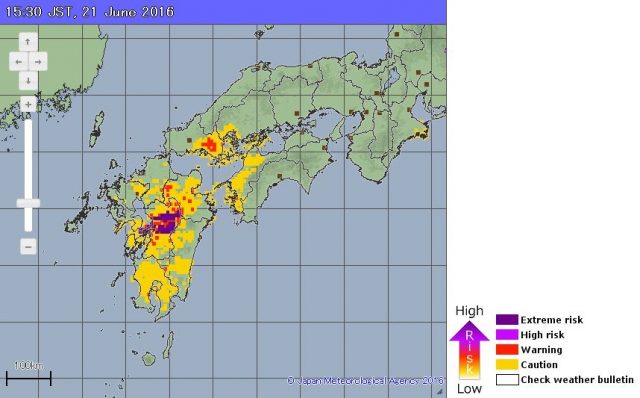
Landslide risk map for the Kumamoto Earthquake zone on 21st June via the Japan Meteorological Agency
.
The agency also provide precipitation data online, which makes sobering reading. This is the record for the Kumamoto weather station, based on hourly records:
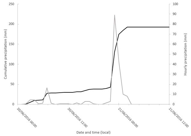
Precipitation data for the Kumamoto weather station, data via the Japan Meteorological Agency. The grey line is hourly precipitation (right hand axis), the solid line the cumulative rainfall since 00:00 on 20th June 2016 (left hand axis)
.
Rainfall will have been very variable across the region, but in Kumamoto itself the impact seems to have been a short burst of extremely intense rainfall – 89 mm fell in a single hour. Sadly this occurred late in the evening, when people are least likely to be able to see or even hear a landslide coming. Kosa, mentioned above, is even worse:-
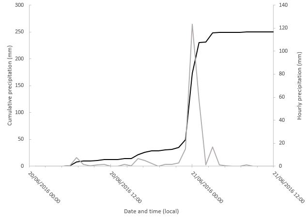
Precipitation data for the Kosa weather station, data via the Japan Meteorological Agency. The grey line is hourly precipitation (right hand axis), the solid line the cumulative rainfall since 00:00 on 20th June 2016 (left hand axis)
.
In this case the maximum hourly precipitation was a staggering 123.5 mm. Again the most intense rainfall arrived in a short duration, very high intensity burst with devastating consequences. This is one of the landslides in Uto:
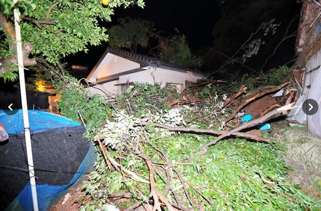
A landslide in Uto, in the Kumaoto Earthquake area, via Jun Kaneko and The Asahi Shimbun
 Dave Petley is the Vice-Chancellor of the University of Hull in the United Kingdom. His blog provides commentary and analysis of landslide events occurring worldwide, including the landslides themselves, latest research, and conferences and meetings.
This spike in slides makes perfect sense to me.
In 1992, we had the 7.1 Petrolia quake sequence here on the north coast of CA.
In 1995, I came to the coast as a geologist working as a regulator in the timber industry. This was a boom time and I was very busy evaluating numerous timber projects in the mountainous countryside.
The winter of 1996-1997 was one of the hardest on record, and everything that could blow out, did so, most particularly within 30 to 40 miles of the epicenters. Since that, rainfall was lower (actually went into a drought cycle) and things were relatively quiet, slide-wise.
This past El Nino winter, we had heavy rains again. Starting to see occasional big slides, but nothing like the years right after the Petrolia sequence.