
27 September 2015
Tonzang landslide: a new giant landslide in Chin Division, Burma (Myanmar)
Posted by Dave Petley
Tonzang landslide
Late in July extremely heavy rainfall affected Chin Division in Burma (Myanmar), triggering extensive landsliding and flooding. This event has been very little reported, but all of the indications were that the impacts were substantial. I have been trying to track down further information about this event ever since, and have now come across some information about it. In particular, it is now clear that the rainfall triggered what appears to be at least one giant (i.e. > million cubic metre) landslide. Whilst the area has been cloud covered since the disaster, Unosat have managed to obtain a partially cloud-free Pleiades image of the area, and have posted an interpretative image on their website:-
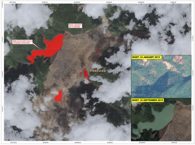
Tonzang landslide via UNOSAT
..
This is a very large landslide – the red area is the lake that has formed behind the landslide dam – this is 34 hectares in surface area according to UNOSAT. The part of the landslide that is visible here appears to be more than a kilometre wide and at least 3 km long. But note that all we are seeing here is the deposit – the track and source are somewhere beneath the cloud off the image. Colin Stark has very kindly overlain the image onto the Google Earth imagery of the area, giving an indication of the portion of the landside that we can see, and a symbol to indicate the likely source area:
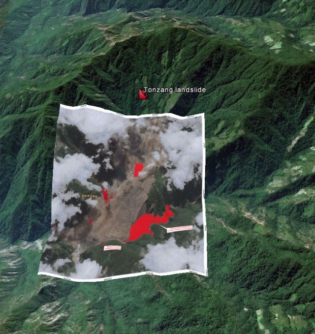
Tonzang landslide – UNOSAT image overlain onto Google Earth, courtesy of Colin Stark
.
As the monsoon withdraws the chances of getting a decent satellite image of the Tonzang landslide will increase, and this is a landslide on such a scale that it will be readily identifiable on Landsat 8, and suchlike. Watch this space!
Meanwhile, there is a blog featuring landslides in the Hakha City area of Chin Division, Hakha City, being run out of the USA. It has a fantastic selection of images of some of the landslides triggered by this heavy rainstorm event:-
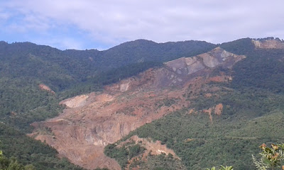
Landslides in the Hakha City area of Chin Division via a blog
.
This area is 150 km or so south of the Tonzang region, so I don’t think the landslides featured here is that in the UNOSAT image. If so, it suggests that this was an extremely large landslide inducing rainfall event, probably the most important of the year to date.
 Dave Petley is the Vice-Chancellor of the University of Hull in the United Kingdom. His blog provides commentary and analysis of landslide events occurring worldwide, including the landslides themselves, latest research, and conferences and meetings.
Thanks for posting the photo of landslide in Hakha City area, which was from my blog and thanks for that. I predicted that some parts of Hakha would be destroyed if the city has torrential rains and earthquakes seven years before some parts of the city was destroyed by the landslide in July 2015. I lived there for 2-3 years when I was in high school and I saw many changes of the landscape in the area around the city. I wrote two articles about the landslide in the city that the city would face in the near future and suggesting to establish a new city and relocate some houses before the destruction of the city. CBCUSA gave us $2,000 to do survey around the city and we did. Before we finished the survey, some part of the city collapsed because of landslides. It was huge problem for the whole city. Many families became homeless in one night.
The landslides are very common in this Chin State, western part of Myanmar, since the mountains high and the gorges are too deep and the slopes of the hills are too steep. The rocks and top soils are very soft and the erosion occurred everywhere in the region during the monsoon. This region is extremely dangerous if there is a torrential rain or in time of strong earthquake. If those two combination happen it will create havoc in the region. It can cause severe damages in their infrastructures and it will create extreme hardship.
This region need help from the experts such as geologists and earth-scientists to study the rapid changes of the landscape in the region to educate the people in term of land’s usage and maintaining the erosion and avoiding the future disasters like in 2015 landslide in Hakha that destroyed about 800 houses in the city. It was a great disaster for the city and surrounding areas. Thanks for the blog. I am really tankful for it.