
12 August 2014
The Eaglepointe Landslide in Salt Lake City, Utah
Posted by Dave Petley
The Eaglepointe landslide
One of the many landslide events in the last few days was a slide in the Eaglepointe subdivision in Salt Lake City in Utah. The development of this landslide was brilliantly caught on a time-lapse video by KUTV reported Holly Menino and 2News photographer Mike Stephen:
.
Jeff Moore of the University of Utah has very helpfully put together the following incredibly useful briefing on the Eaglepointe landslide:
- On Tuesday morning Aug 5, around 6 am, a large landslide underwent rapid and sustained failure, displacing some tens of meters over a period of minutes.
- One house was destroyed and three others imminently threatened. A nearby gas pipeline was undamaged.
- Movement had initiated at least four months prior back in April (our wet season), by some accounts back in fall 2013.
- In the week before the slide, large tension cracks had been growing at the crest of the slope, and the toe area was bulging creating some distress to adjacent properties.
- The developer hired geotechnical consultants to install inclinometers at the crest, and homeowners were diligently observant of the slope.
- Residents had received a letter indicating that there was a slide and to be prepared, but most seem to have already known due to the obvious signs of ground distress.
- During the morning of the failure, rolling boulders from the toe woke one of the 12 residents in the destroyed home, who then woke the rest of his extended family and everyone evacuated from the house before it collapsed.
- Movement later slowed but the scarp and slide mass threaten more homes.
- A heavy monsoon rain storm the previous evening is the ascribed trigger of ultimate movement, although slow displacement had been ongoing for months.
- My preliminary volume estimate of the slide is ~300,000 m3, based on the aerial extent and an assumed average depth of 10 m.
- The slide mass consists of sands and gravels of the Lake Bonneville highstand, overlain atop Tertiary volcanic tuff – the latter is a notorious material for landslides in the northern Utah, the so-called Norwood Tuff. It weathers to swelling, water-sensitive clays. The condition or depth of the sliding surface is however, not known at this time.
- Another slide just 1 km away in similar stratigraphy (named Springhill) destroyed several homes over an extended period in 1998 and during later wet years. Yet another slide in the same geology is progressively destroying several residential lots in nearby City Creek.
- The development was a gravel quarry until the late 1990’s, and the area that slid was the highwall or maximum extent of quarrying. It had been graded at 2:1 (~25 degrees). The houses threatened were built in the mid-2000’s. New development is currently underway at the crest of the slope that failed, including new roads and several new homes.
- Geotech reports used by the developer and city to permit the previous and new construction deemed the slope globally stable. These can be downloaded and freely reviewed here: http://nslcity.org/index.aspx?NID=331
- Some smaller sluffs and slides had been observed in previous years especially around the base of the slope where small cut-backs had been made.
- Location: https://www.google.com/maps/@40.8274081,-111.9022917,295m/data=!3m1!1e3 – to the north of the slope you can see the covered tennis courts and home immediately west that sustained the most damage, as well as some clearing for development at the crest of the slope (south).
Standard.net has a great gallery of images of the landslide. This image from that set shows the state of the eaglepointe landslide site now:
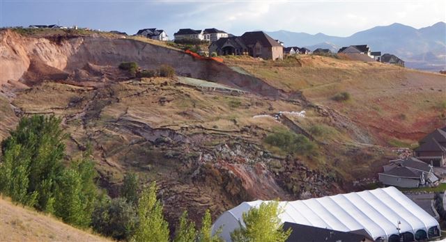
http://www.standard.net/Local/2014/08/06/North-Salt-Lake-residents-blame-city-for-landslide.html
.
Given the history of the site I think that it is unlikely that the Eaglepointe landslide can be considered to be a natural event. However, it is not clear to me who, if anyone, might be to blame.
 Dave Petley is the Vice-Chancellor of the University of Hull in the United Kingdom. His blog provides commentary and analysis of landslide events occurring worldwide, including the landslides themselves, latest research, and conferences and meetings.
Another nice gallery of photos can be found here:
http://www.sltrib.com/csp/cms/sites/sltrib/pages/slidegallery.csp?cid=58263929&pid=6412383