24 April 2014
Landslide losses – raising the profile in the USA
Posted by Dave Petley
Landslide losses in the USA
The two dramatic landslides of the last few weeks in the USA has undoubtedly raised the profile of this natural hazard. The Oso landslide in Washington State remains high on the news agenda, and was even visited by the President earlier this week. Meanwhile, the fascinating East Gros Ventre Butte landslide in Jackson Hole continues to creep, with devastating impacts on the family who owned the house at the crest of the slide.
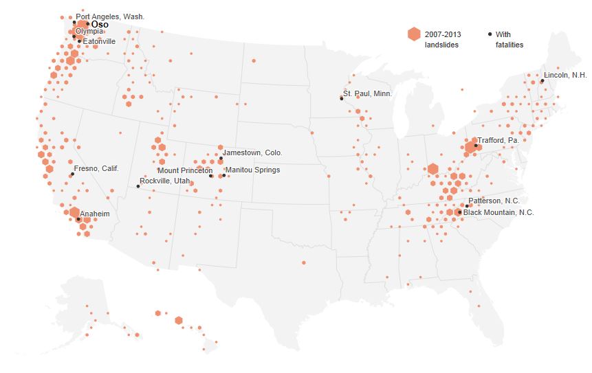
These two events have suddenly driven a new level of interest in landslide losses in the USA, which may be a good outcome from these tragic events. National Geographic has produced a fantastic graphic illustrating the distribution of landslides across the USA since 2007:
…
This graphic uses data that Dalia Kirschbaum and colleagues at NASA have been collecting on landslide events around the world. It shows reported landslides in the USA since 2007. Note that the National Geographic page has more detailed explanations of the distribution of the observed landslides, so I won’t attempt to repeat it here. However, in general reported landslide incidence is highest where there is a combination of steep terrain, high rainfall, active tectonic processes and people. Those four factors alone provide an explanation for most (but not all) of the landslides shown above.
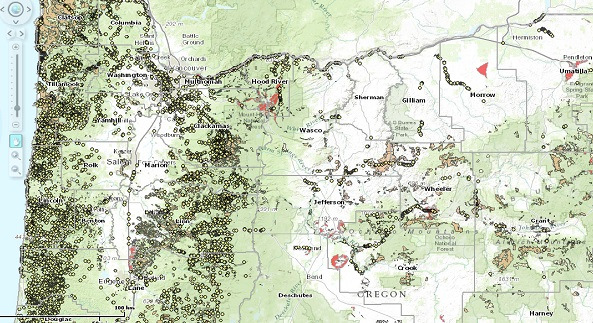
In addition, there has been increased interest in State and more local-level landslide inventories. So, for example, this article describes the incidence of landslides in Oregon, and includes this map of landslides across the state:

KOIN6 and Oregon Department of Geology and Mineral Industries
…
A key issue in the US media is why there is no national scale landslide mapping programme in the USA – a good question! In my view landslide work in the US has been grossly underfunded compared with other hazards (this article notes that the entire landslide programme at Federal Level costs $3.5 million per year – in comparison the Bingham Canyon landslide alone is thought to have cost about $1 billion), although the landslide teams at the USGS and elsewhere are world class. In addition, there is little doubt that excellent and comparatively low cost landslide programmes at the State level have been killed off for political purposes. A subsidiary question is whether warning systems in the most dangerous places could save lives. The answer is of course yes – principles and techniques of landslide warning systems are well-established and have proven to be effective elsewhere. They are however expensive and labour-intensive. Unfortunately, both the Jackson Hole and Oso landslides will soon slip from the memory of most, and I fear that little will change. Expect further hand-wringing when the next large event occurs – and given that we appear to be entering El Nino conditions, that may not be too far in the future.
Landslides are probably the most preventable of all natural disasters. At a national level there is no excuse for failing to manage them properly.


 Dave Petley is the Vice-Chancellor of the University of Hull in the United Kingdom. His blog provides commentary and analysis of landslide events occurring worldwide, including the landslides themselves, latest research, and conferences and meetings.
Existing house on septic – tall, unretained cut slope for strip mall below.
Reminds me of this case last year:
http://www.sfgate.com/science/article/Lake-County-homes-swallowed-by-slide-4520472.php
Google Earth
39/06/23.72 N
122/54/33.6 W
This subdivision was on storm sewer, but may have been triggered by leaky lines that appeared to have been recently re-worked based on the fresh asphalt visible earlier 2010 Google photo. Still in litigation, so not much information available. Ground cracks show up well in the latest two photo sets.
The Preliminary Jackson, WY Potential Landslide Map is generated and posted for viewing here:
http://www.geological-assessments.com/Jackson_WY_Landslide.html
Rather astonishing that the NatGeo story doesn’t even mention logging and mining as major causes for landslides. This entire thing is great cinematography but for the landslide part start around 5 minutes in: https://www.youtube.com/watch?v=lferrcK4cwQ