
25 March 2014
The Steelhead landslide in Oso, Washington State
Posted by Dave Petley
The Steelhead landslide
The death toll from the Steelhead landslide near to Oso in Washington State is continuing to rise. Latest reports suggest that there are now 14 known fatalities, but 176 people are reported to be missing. It is quite normal in this sort of event for the number of reported missing people to exceed substantially the actual number of victims, so this maximum toll may reduce in the next few days. However, it is still likely to be the costliest landslide in terms of lives lost for many years in the USA.
Details are slowly emerging of the landslide history of this site. It is clear that major landslides have occurred here on many previous occasions; indeed so much so that the landslide is known as either the Hazel landslide or the Steelhead landslide; at this stage I am opting for the matter given that the inundated area is known as Steelhead Drive.
Better images of the Steelhead landslide
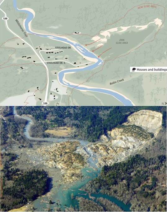
I very much appreciate the help that numerous people have given me over the last few days to put together this post – too many to name, but thanks to you all. The best graphic that gives an overview of the slide is in the Seattle Times:
..
The original version has a very impressive slider function that allows the user to flip from one image to the other. I can’t replicate that, but putting the two images side-by-side shows the extent of the devastation. The number of inundated houses is large, suggesting that the loss of life will be high, especially bearing in mind that the slide occurred on a Saturday.
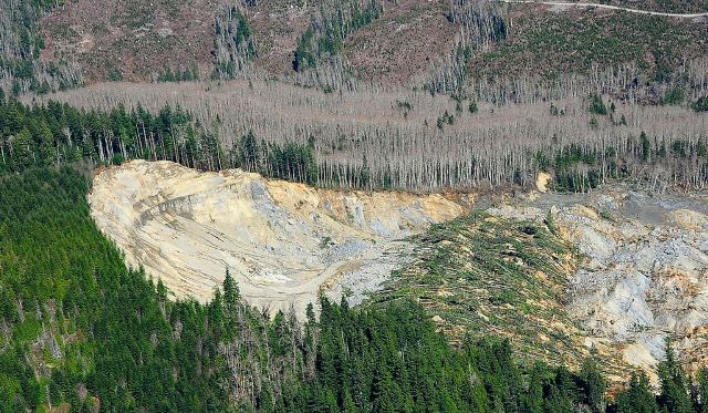
The best set of aerial images of the slide are on the Flicker page of Governor Jay Inslee – there are some wonderful images there. This image shows the source of the landslide:
..
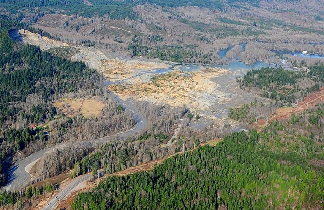
Whilst this image from the same source shows the entire landslide mass.
..
The landslide has been widely reported as a mudslide. In terms of the lower portion, which did the damage, this is correct, although in places it might have been more of a mudflow than a mudslide. However, the upper portion is a rotational landslide – the rotated block with the fallen trees is very clear. A working hypothesis would be that this block failed catastrophically, transferring load onto the block below, which in turn generated very high pore water pressures, causing fluidisation and a very rapid mudflow that struck the settlements across the river.
The history of the Steelhead landslide
The Yakima Herald has a very nice article that details the chronology of events on the Steelhead landslide. This includes:
- 1949: A large landslide (1000 feet long and 2600 feet wide) affected the river bank
- 1951: Another large failure of the slope; the river was partially blocked
- 1967: Seattle Times published an article that referred to this site as “Slide Hill”
- 1997 report, by Daniel Miller, for the Washington Department of Ecology and the Tualialip Tribes
- 1999: US Army Corps of Engineers report by Daniel and Lynne Rodgers Miller that warned of “the potential for a large catastrophic failure”
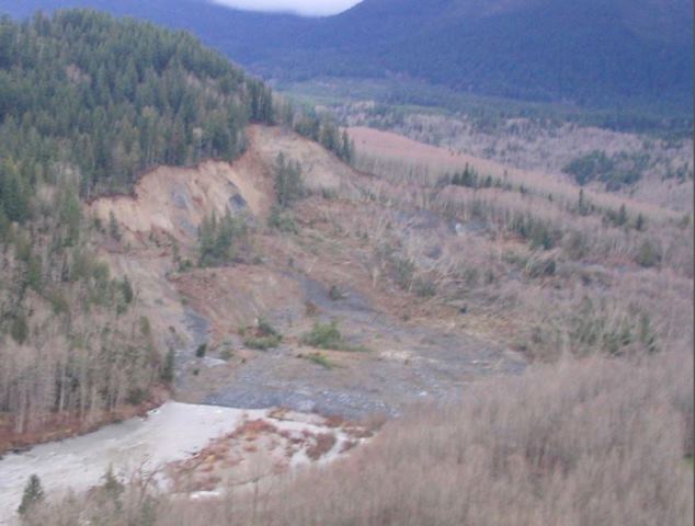
- 25 January 2006: large movement of the Steelhead landslide blocked the river
There is a good presentation about the 2006 landslide available online (NB pdf). This includes the following (somewhat blurry) image of the source of the 2006 landslide:
http://www.stillaguamish.nsn.us/Publish/Steelhead%20Landslide.pdf
..
The slope that formed the scarp of the 2008 slide was undoubtedly very over-steepened, and of course was formed from weak materials. This looked like an accident waiting to happen.
 Dave Petley is the Vice-Chancellor of the University of Hull in the United Kingdom. His blog provides commentary and analysis of landslide events occurring worldwide, including the landslides themselves, latest research, and conferences and meetings.
Dave, your proposed mechanism/chronology seems reasonable. But what do you make of the twin seismic signals ~5 min apart?
http://www.king5.com/news/local/Anatomy-of-a-slide-252082351.html
It’s sobering to realize that all those idyllic riverside houses in the 8th frame of the presentation would be obliterated 8 years later.
The diagrams with the slide/river/houses really helped me understand the catastrophic results of this landslide.
If you can find a copy of Monday’s NY Times, check out the picture on page 10 (? I think). It was a side view of the location from the air and it clearly showed a similar landslide in the background only a few hundred yards away. The forest may have covered the evidence but the semi-circular scarp formed by the rotational origin of the movement is quite clear.
Estimated size of #530slide : 6-7M cubic yds.
http://washingtondnr.wordpress.com/
immediately hearing about this, in 2014, i went to google maps and watched the footage of that area, seeing people getting their mail, walking, running…same area that was buried. i called a relative in wa, who might be able to contact family members, to grab this footage of their loved ones.