
12 June 2008
Debris flow video from Hong Kong
Posted by Dave Petley
Thanks to a former student for bringing the following video to my attention. Hopefully it will play directly when you click on the box below – if not then take a look at:
http://www.youtube.com/watch?v=R2uTKyK1c9k
This channelised debris flow occurred on Lantau Island, near to Hong Kong airport, on 7th June when the area was affected by an exceptional (“black”) rainfall event. In a single hour Hong Kong observatory recorded 140 mm of rain, the highest intensity on record there. During the day, which saw over 300 mm of rain across most of the area, about 400 landslides were triggered on Lantau alone, including one that killed two people.
Helpfully, the Hong Kong Observatory make rainfall isohyet charts available online. I have annotated below the map for 7th June and the approximate location of the landslide. Note that the landslide occurred in an area in which rainfall totals were at their highest (>400 mm).
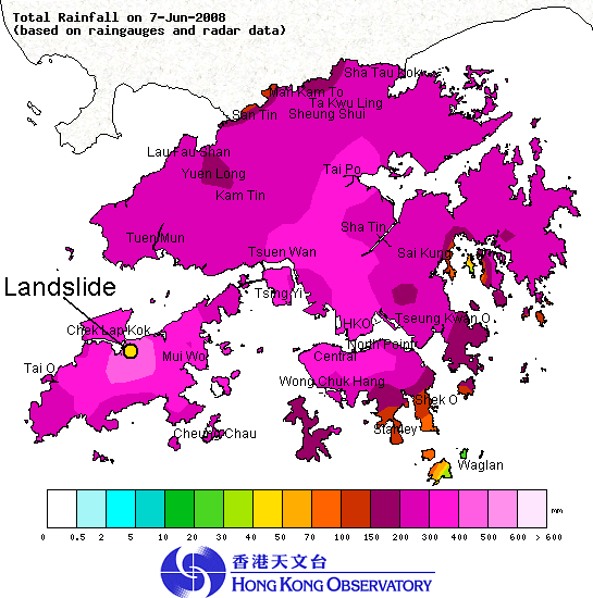 Hong Kong Observatory isohyet map of the rainfall distribution for 7th June 2008. The approximate location of the landslide in the Youtube video is indicated.
 A couple of words about the landslide. This is technically a channelised debris flow. It appears to have started as a comparatively small shallow slip in weathered materials high on the slope. The mobile material has then picked up (technically this is termed “entrained”) debris and water in the channel. Once such flows start, and assuming that they have a steepish slope to travel down, they build momentum and volume to create a highly turbulent and destructive pulse of material that moves very rapidly. Slides of this type typically occur in pulses, as can be seen in the video, which is of course particularly nasty for people in the way. Needless to say these types of flow are very dangerous, particularly if they overflow the channel banks. Fortunately, in this case the flow appears to have remained mostly in the channel itself.
Hong Kong has a long history of these types of landslides, and is adept at managing them. To enhance this the Hong Kong government has just started a large project to identify natural terrain areas prone to these failures and to mitigate areas of high risk.
 Dave Petley is the Vice-Chancellor of the University of Hull in the United Kingdom. His blog provides commentary and analysis of landslide events occurring worldwide, including the landslides themselves, latest research, and conferences and meetings.
Dr. Dave and Dr. Angel Ng,Thanks a lot for interesting clip. Have they any plan to do mathematical simulation of this actual phenomenon?
I think GEO Hong Kong have been modelling debris flows using Oldrich Hungr’s DAN model with some success. The major problem is that it is necessary to tune the parameters carefully, which means that it is easy to simulate retrospectively but hard to predict.Dave
Dear Dr Dave,Thanks for the video. It looked pretty powerful and destructive.The HK Govt identified 12 slopes yesterday. I would appreciate it if you would post where these 12 slopes are and what precaution the govt could take.more heavy rain falling right now. they hoisted the yellow warning this afternoon.cheers!wai
yes, i have done the simulation… i am going to visit the site next monday to get more data for calibration.prof. debris
[…] during the monsoon, these landslides have the potential to turn into very devastating debris flows (such as the famous Hong Kong event of a few years ago, shown in the video below). In such conditions road users and the inhabitants of some of these houses would be at high […]
[…] The June 2008 Lantau debris flow in Hong Kong […]
[…] In essence this event will be down to inappropriate design of the channel below the road. It highlights the difficulty of designing structures that are able to handle the very short lived, high discharge events that occur when chanellised debris flows evolve from slope failures. As usual, I highlight the video from the 2008 Lantau events in Hong Kong to illustrate the dramatic and devastating effects…. […]
[…] There is a debris trail from the shallow failure to the main channel, with evidence of erosion and entrainment. This is similar to the series of events that often leads to channelised debris flows in Hong Kong. […]