
30 May 2014
Leaving Durham University
Durham University
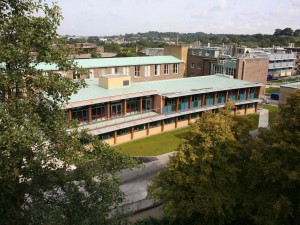 I’ve been at Durham University for almost 14 years, having joined initially as a lecturer in September 2000. It has been a wonderful place to work, full of extraordinarily talented colleagues and students and set in a beautiful medieval city. My career has progressed in ways that I would never have believed possible – I was made a Reader at Durham University in 2004 and then promoted to an endowed Chair in 2006. Later that same year I became Deputy Head of Faculty (Research) in Social Sciences and Health. In 2011 I took over as Executive Director of the Institute of Hazard, Risk and Resilience, and then in 2012 was made Dean of Research. Finally in 2013 I was appointed to Dean of Research and Global Engagement.
So, it is with great sadness that I am today announcing that I’ll be leaving Durham University in mid-September.
The University of East Anglia
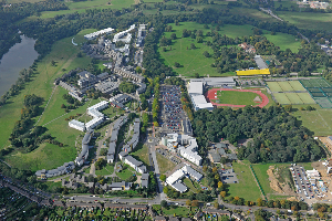 I’m very excited to reveal that I’ll be moving the University of East Anglia, which is located in Norwich, to the north of London. I’ll be taking up the role of Pro-Vice Chancellor (Research and Enterprise), which leads on the strategic development of research and enterprise activities across the institution. I think in US terms this is similar to, but not quite the same as, a Vice-President role. I’ll also be taking up a Chair in Environmental Sciences This is a wonderful opportunity – UEA is a fabulous university with excellent staff and students.
The University has a press release about my appointment here.
I will be maintaining my research on landslides at UEA, and am looking forward to collaborating with colleagues there. I’ll also be continuing to work with my friends, colleagues and students at Durham and beyond.
And of course I can also assure you that I’ll be continuing to write this blog when I move.
28 May 2014
Grand Mesa: an unusually large and mobile mudslide
The Grand Mesa mudslide
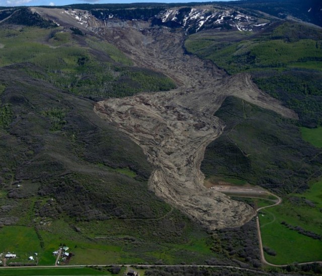
Mesa County in Colorado, USA suffered an unusually large and mobile mudslide this weekend, which appears to have resulted in the deaths of three men. The landslide is surprising in many ways, not least the scale and the apparent mobility of the mass. The Denver Post has a great set of images of the landslide, including this one:
Aaron Ontiveroz/The Denver Post
..
The scale of the landslide can best be appreciated from this video, taken by the Mesa County Sheriff’s Office:
..
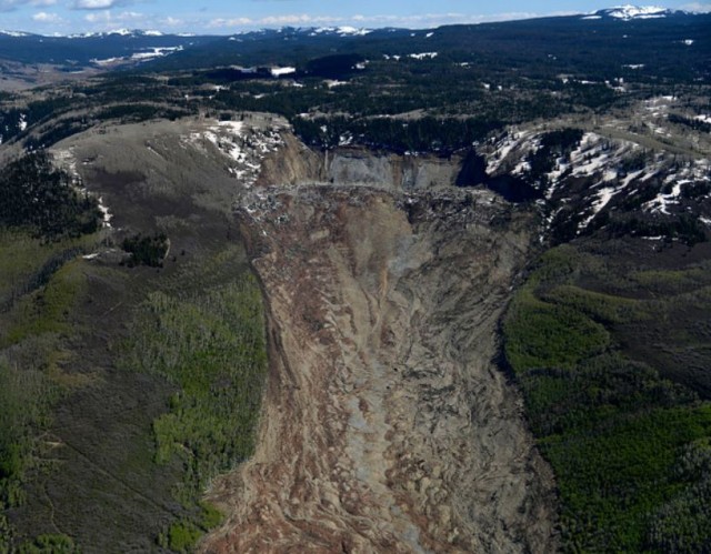
The landslide is reportedly half a mile (900 m) wide and between 2 and 3 miles (3.5 – 5.1 km) long. The victims appear to have been investigating reports of a blocked irrigation canal, presumably from an earlier movement event. The mobility of the landslide does seem to be unusual – note how the slide has overtopped a ridge on the right side (as seen in the photograph above). The elevation reached by the mass on the upslope side of this ridge is quite surprising.
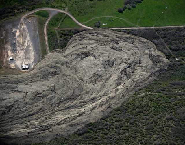
The landslide mass has some fascinating flow structures that with interpretation will tell us a great deal about the movement of the landslide. For example, this Denver Post image of the landslide shows the structures in the toe area. To me, this suggests that the landslide should really be classified as a mudflow rather than a mudslide, or in fact technically as a complex landslide consisting of a rotational landslide that transitioned into a mudflow:
Aaron Ontiveroz/The Denver Post
..
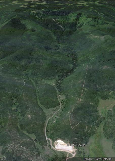
This is the Google Earth perspective view of the site before the collapse (this image is dated 2011):
 ..
..
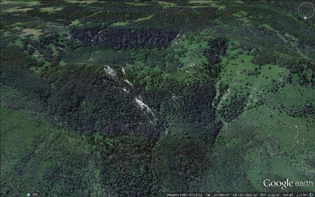
The upper reaches of the landslide clearly consist of an old rotational landslide block – this is clearer on a zoomed in image:
 ..
..
Compare this with the Denver Post photograph of the same area after the recent failure:
Aaron Ontiveroz/The Denver Post
..
It is quite hard to interpret this, and my initial view (that there was a new rotated block) is not the case I think. My reading is that the forested rear scarp of the old landslide remains intact. The rotated block appears to have undergone a second rotational failure, possibly on the same failure plane? A part of this rotated block has remained intact, but most has disintegrated to form the mudflow. Rotated blocks do degrade and form mudflows – this is the case in many such slides. But this catastrophic disintegration to form a high mobility mudslide looks really interesting, so will merit a detailed investigation. Perhaps the whole mass underwent a rotational failure, which caused the lower part of the block to disintegrate and form the flow.
Given that the reported rainfall prior to the failure was nothing special, something quite unusual seems to have happened here.
Unfortunately, the site looks to be quite dangerous, especially in the next heavy rainfall. I wonder also what the platform at the toe of the slide is for (see the second image above)? There are several similar structures in the area around the landslide.
21 May 2014
Zenica: a spectacular landslide video from Bosnia
Zenica landslide
This video has appeared on youtube. It shows the development of a landslide triggered by the exceptional rainfall that struck the Balkans over the last few days. The landslide apparently occurred at Zenica, Bosnia and Herzegovina.
https://www.youtube.com/watch?v=kaisf_N_ODQ
This landslide will have been a tragedy for the owners of the houses, which are very unlikely to have been insured. Initially most of the damage is focused on the lateral shears (the edge of the landslide), on which the group of houses are located. In the 3 minutes of the video these are completely destroyed. Note also the rate at which the rear scarp develops though. The resulting motion tilts and then collapses the house in the lower part of the landslide.
20 May 2014
Dariali Valley landslide: images of the failure
Dariali Valley landslide
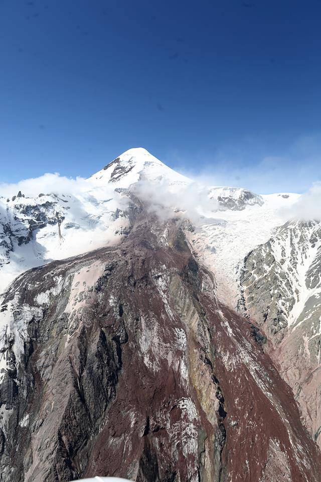
Yesterday I posted about the large, valley-blocking landslide that occurred in the Dariali Valley of Georgia on Saturday, killing up to eight people. Michail Dokukin very kindly posted a link to a site with a set of photographs, taken from the air, of the landslide. This is the upper reaches of the failure, which appears to have started as a large but shallow failure beneath the glacier:
http://cyxymu.livejournal.com/1546134.html
..
The initial failure appears to have involved both rock and ice, and then to have swept down the valley at high speed judging by the amount of super-elevation on the bends in the channel. It is likely that the flow also entrained sediment from within the channel en route. This is a better view of the source area, with some unfortunately located cloud:
http://cyxymu.livejournal.com/1546134.html
..
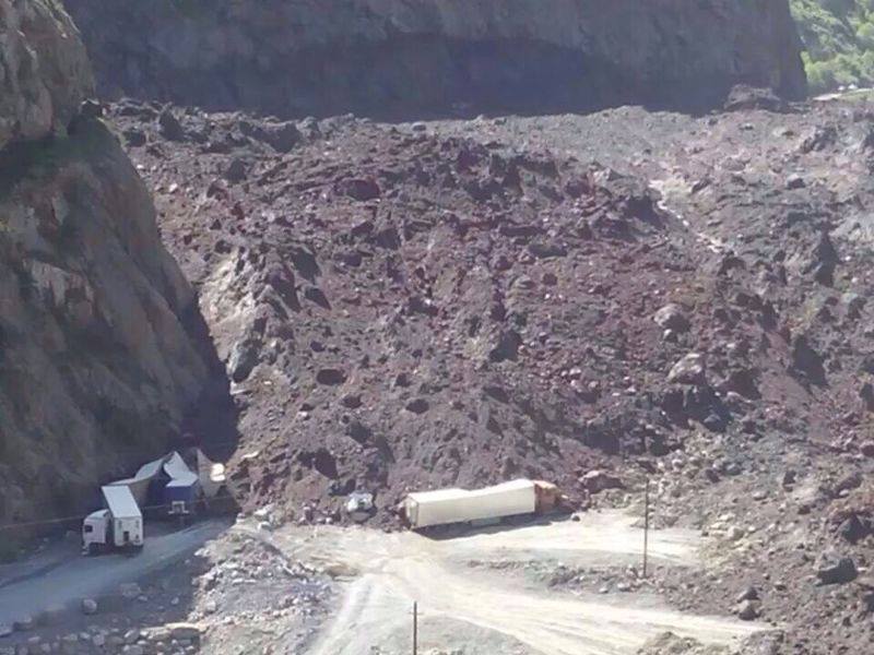
And this image, although low resolution, gives an impression of the scale of the Dariali Valley landslide. Interestingly, there is not much evidence of ice in this mass as far as I can see, and there is little evidence of melting:
http://cyxymu.livejournal.com/1546134.html
..
Media reports that the Dariali Valley landslide was unconnected with the hydroelectric scheme under construction nearby are likely to be correct. There are many other images of the landslide on the livejournal blog – it is well worth a visit.
19 May 2014
Dariali Valley: a valley-blocking landslide that has killed three and left five missing
Dariali Valley
Late last week a landslide occurred in the Dariali Valley in Georgia, killing three workers from a hydroelectric project, and leaving a further five missing. The landslide, which is estimated to be about 1 million cubic metres, was triggered by heavy rainfall. Whilst images of the landslide are not plentiful as yet, this one suggests that it has blocked the river:
..
From Iago Kazalikashvili via http://dfwatch.net/five-missing-after-massive-landslide-in-georgia-92244
..
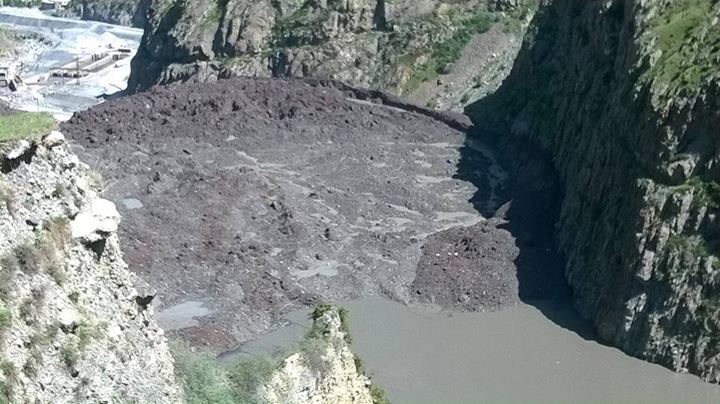
Democracy and Freedom Watch have a good article about the landslide, which indicates that the landslide has severed the gas pipeline that links Russia and Armenia and the road between Russia and Georgia. There are also concerns about flooding as the lake builds. Looking at the image below, those concerns are well-placed:
http://dfwatch.net/environmental-group-warned-about-landslide-risk-90868
..
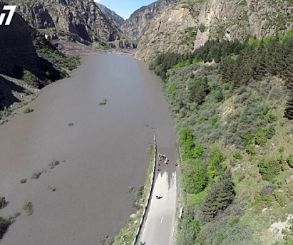
However, this article today plays down the risks and indicates that water may have started to flow past the blockage.
The Dariali Valley landslide and the hydroelectric scheme
Apart from the obvious threat that the landslide poses, an interesting aspect of the event is the potential link to the Dariali Valley hydroelectric project. I have written previously about the worryingly high incidence of fatal landslides associated with these projects in high mountains. Democracy and Freedom Watch notes that the issues of landslides associated with this project had been highlighted previously. There is no evidence to link the project with the landslide at this stage, but in the first image above parts of the hydroelectric scheme, under construction, are visible. This is in contrast with this article, which states that the landslide was 20 km from the site of the hydroelectric scheme. Agenda.ge has an article that attributes the landslide to “extreme movements of an icy glacier located high on a mountain peak”. I am not sure what this means.
14 May 2014
The Tumbi Quarry landslide – a new documentary
The Tumbi Quarry landslide
The Tumbi Quarry landslide occurred in Papua New Guinea on 24 January 2012, killing at least 25 people. The landslide was both large and catastrophic:
The landslide occurred in a quarry that had been used by contractors working for Esso Highlands, on a natural gas pipeline. Despite the fact that the landslide originated at the quarry, and indeed destroyed it, ExxonMobil have repeatedly denied that they two are linked. I have always found this difficult to understand.
A new documentary about Tumbi Quarry
In the last two weeks a new documentary has been released that investigates the Tumbi Quarry landslide, which is a companion piece to an article in the Nation magazine. Both are excellent pieces, spelling out the injustice that has been done to the local residents and the lack of a proper, open investigation of the landslide. An interesting aspect is featured in a companion piece on the Radio Australia website. This highlights an interview that Ian Shearn did with Gerson Yakasa an engineer working with ExxonMobil sub-contractor MCJV. This is the key part of the interview:
YAKASA: I talk to the director and I sent an email to everybody else that the operations in the quarry were risky and the quarry should be you know shut immediately
SHEARN: Did you say that in the email?
YAKASA: Yes, I thought the quarry would collapse.
The Radio Australia piece then notes that “Mr Yakasa said he saw numerous large cracks in the face of the quarry and clear evidence of slope instability.”
This case continues to bemuse me. ExxonMobil continues to maintain that the landslide was not linked to the quarry, but with the lack of a proper investigation that is impossible to know. Two independent sources have told me that ExxonMobil commissioned external consultants, including at least one renowned landslide expert, to investigate the landslide (I should note that I have no way to know for certain whether this is the case). But if so, and if it found that the quarry was not to blame, why has it not been released? I find that quite surprising.
There is still a need for a proper independent investigation of the landslide. That it has not been undertaken is deeply unjust.
6 May 2014
New photos of the Ab Barak landslide in Afghanistan
Photographs of the Ab Barak landslide
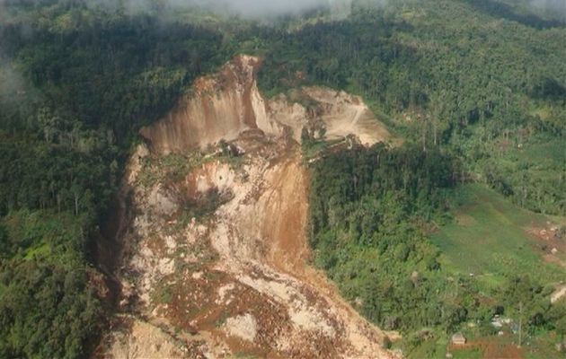
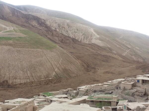
The Atlantic has a wonderful gallery of images of the Ab Barak landslide in Afghanistan. There are 22 images to choose from, including this fantastic overview of the whole landslide:
From The Atlantic – (AP Photo/Rahmat Gul)
..
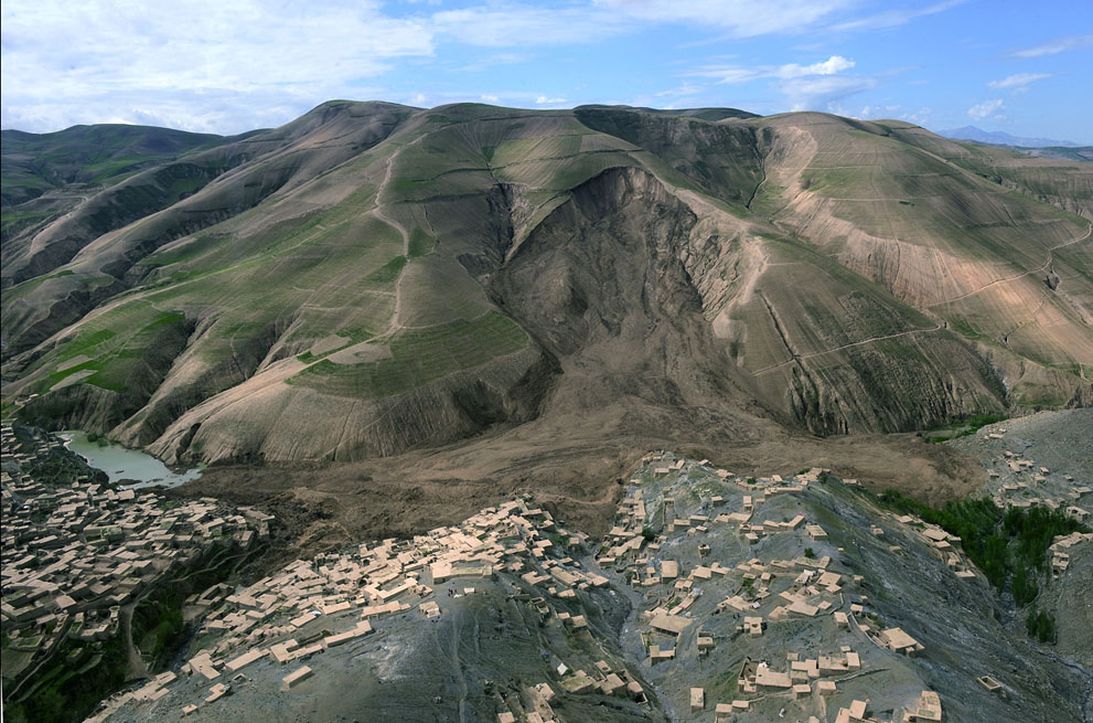
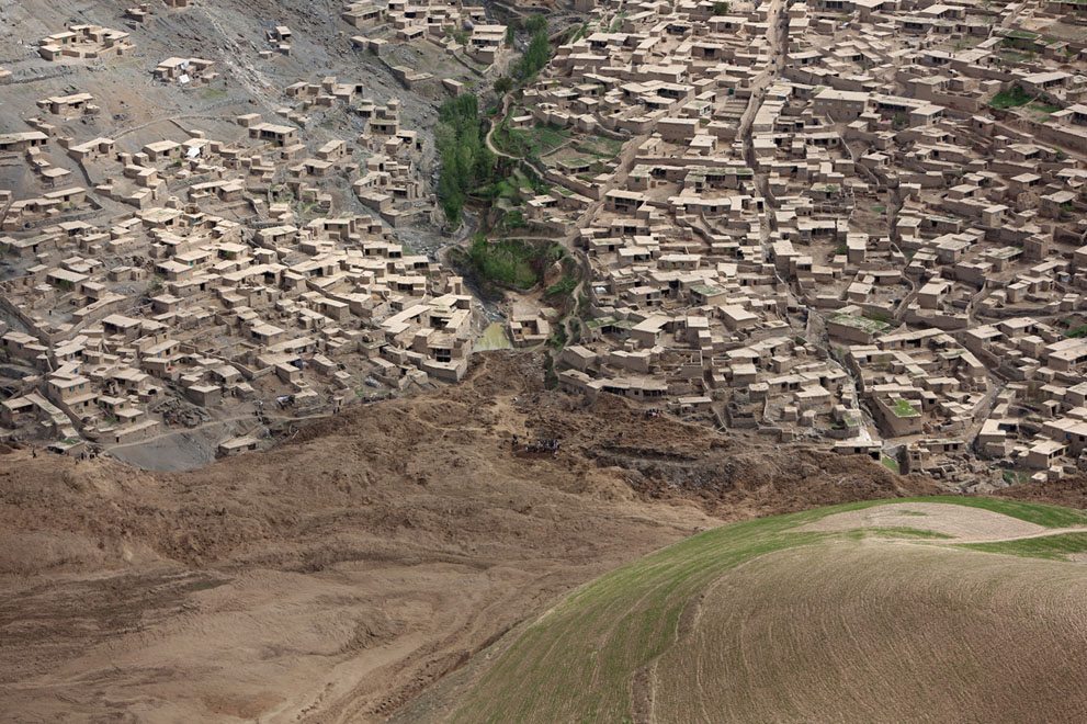
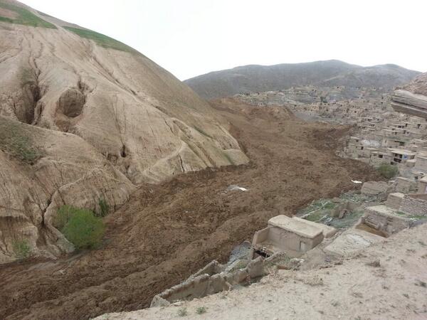
There is a great deal to note from this. First, I think that the image confirms that the Ab Barak landslide is in loess (i.e. a deposit of windblown dust). All of the features visible, including the nature and colour of the material, the lack of boulders and the gullying in the areas around the landslide suggest that this is a loess landslide. Sue Kieffer has a very nice post on her blog about why loess is so susceptible to landslides. Second, the mobility of the landslide is clearly evident, and in particular the way that it has flowed up and down the main valley, and up the side valleys too. Third, the large, old landslide scar next to the recent one (on the right side) suggests that this is a material that is prone to landslides. And fourth, this other landslide scar probably indicates the likely future of the Ab Barak landslide site. The old scar extends almost to the ridge line, whereas the recent one has left a great deal of material intact on the slope. There is a partially detached mass on the left side of the new scar, but the remainder of the scar is over-steepened and is likely to fail in due course. If this occurred as another large landslide then the material would over-run the existing deposit and would threaten the houses in the surrounding area. I can see little alternative to relocation of those properties if the safety of the inhabitants is to be assured. The image below shows just how close some of these houses are to the landslide deposit:
From The Atlantic – (AP Photo/Rahmat Gul)
Note also the lake building up on the left side of the landslide deposit. This of course poses an additional threat, although the height of the landslide deposit suggests that it will be a while before the lake over-tops. However, the landslide deposit is not as large as is the case for many landslide dams, and the material is of course highly erodible, suggesting that a rapid release might be possible. There is a need to mitigate the threat quite quickly, though fortunately we are now entering the dry season in this part of Afghanistan.
Lessons learnt from the Ab Barak landslide?
It is good to hear politicians indicating that disaster risk reduction is becoming increasingly important. Richard Bowden, UN Humanitarian Coordinator for Afghanistan, is quoted as saying:
“I think when you fly over the area itself, and see how the earth moved and the fragility of the environment here, it highlights the long-term risk to the population in this very vulnerable province and the need for long-term preventive measures.”
This is quite correct – I just hope that this is translated into something meaningful. Far too often these sorts of good intentions are not translated into a meaningful programme of work, unfortunately.
5 May 2014
The Ab Barak landslide in Afghanistan – a foreseeable event?
The Ab Barak landslide
At the site of the Ab Barak landslide in Badakhshan, Afghanistan, efforts to recover victims have now ceased, with the focus moving to the 4000 or so survivors, many of whom have been left destitute. There remains considerable uncertainty about the number of victims – sadly this is unlikely to be resolved – with estimates ranging from “over 300” to 2,700. With 300 houses having been buried, and a large number of additional people having entered the area after the initial landslide event, it is likely that the number lost will be at the higher end of the range (though hopefully not as high as 2,700).
Was Ab Barak foreseeable?
Determining the location of the Ab Barak landslide has been challenging, and I am grateful to Kerry Leath of TUM for figuring it out. He has an excellent blog post online about the site of the landslide, in which he has reconstructed the event in Google Earth. I’ll not repeat that here, but the site of the landslide on the Google Earth imagery (from 2004) is of interest:

..
The above image unfortunately crosses the boundary between two Google Earth source images, and of course the area of interest is just within the lower resolution area. The source of the landslide is the easily-identifiable, heavily gullied area just to the right of centre on the opposite side of the valley from the village. That this area was potentially unstable is easily identifiable from the imagery above – it would be even clearer on a higher resolution image or an aerial photograph. Thus, with a basic mapping programme the hazard could easily have been identified and steps taken to manage it. As with the Oso landslide in Washington, we have a foreseeable landslide inducing a disaster – in others words, for whatever reason (which may well be a failure to implement an appropriate study rather a failing on the part of the hazard managers), we have failed to identify and mitigate the hazard properly.
A landslide hazard identification and mapping programme in this highly landslide-prone area of Afghanistan would be far cheaper than the cost of this single landslide. Given that the expertise is readily available around the world to undertake this type of exercise, it is a folly that it is not being done. This of course applies in many other locations as well, as today’s landslide in Nepal also demonstrates.
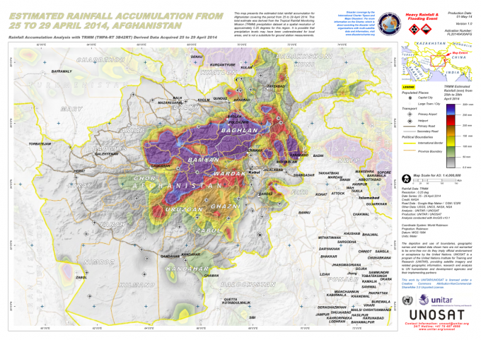
The trigger for the landslide was a period of very heavy rainfall. Reliefweb has a rather nice map, generated with TRMM data, showing the total rainfall accumulation in the period 25-29th April:
..
Kerry Leith notes that a lake is building up behind the landslide mass. He rightly notes that this represents a threat and needs to be managed.
Finally, there is some evidence that the is not the only significant landslide in Afghanistan in the last few days. Bilal Sarwary tweeted this image, from Mohammad Salem Wahdat, of another site, apparently also in Argo District:

Mohammad Salem Wahdat via Bilal Sarwary
..
That is a truly terrifying site. I have no idea of the context of this image (and cannot say for certain that it is from Argo District, though the materials and buildings look to me to reasonable for this area), but if this is an ongoing slide then the level of danger is obviously very high. The village is in effect already lost, being located on a displaced block. but I wonder what is downslope. Does anyone have any more information?
3 May 2014
Badakhshan landslide in Afghanistan – a loess failure?
Badakhshan landslide
The tragic landslide in Argo District of Badakhshan Province, NE Afghanistan yesterday is now believed to have killed at least 350 people, making it the worst landslide of 2014 to date. The best coverage has come from the Twitter account of a BBC correspondent, Bilal Sarwary, who has tweeted a number of images of the slide and the village. These are the best two to date, showing first the Badakhshan landslide itself:
..
And second, the mobility of the landslide debris:
..
The landslide came after prolonged heavy rainfall in the region. Unfortunately, the middle of the day on a Friday is a time when many people are likely to be at home. Bilal Sarwary reports that at the time of the landslide there was a wedding party. The slide occurred in two phases, with an initial slide that buried many people. In the aftermath, many people from local villages went to help, only to be buried by the second landslide. The prospect of finding survivors seems very low.
Was the Badakhshan landslide a loess failure?
The fine-grained texture of the landslide (note the lack of obvious boulders) and the high mobility of the landslide suggests to me that this was a loess landslide. Shroder et al. (2011) identified 34 large loess landslides in this area of Afghanistan, with saturation and liquefaction being a common cause. They also noted that farming practices, and in particular irrigation, can increase the likelihood of landslides in these materials. I have reported on loess landslides previously, most often in China, such as this example from Shaanxi in 2009. and this smaller earthquake induced event from Gansu.
Reference
Shroder, J.F., Schettler, M.J. and Weihs, B.J. 2011. Loess failure in northeast Afghanistan. Physics and Chemistry of the Earth, Parts A/B/C, 36 (16), 1287–1293.
2 May 2014
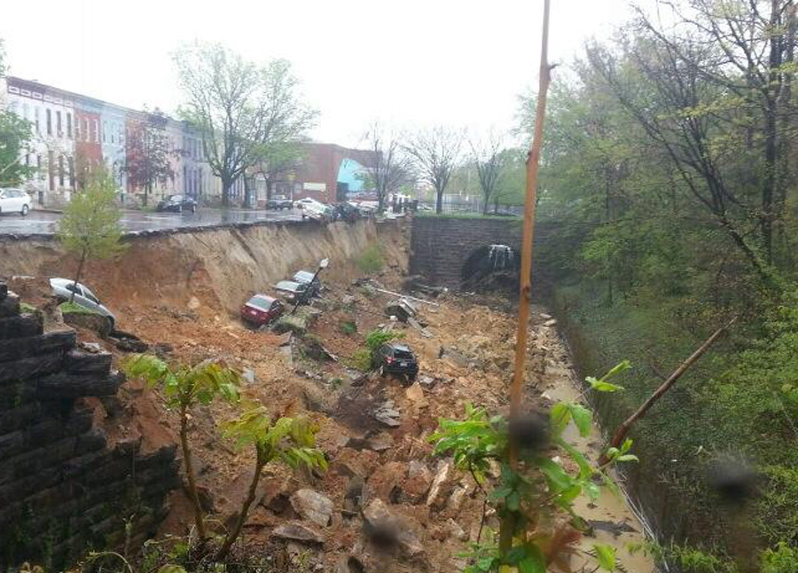
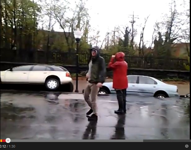
Baltimore retaining wall collapse – the remarkable video
Baltimore Retaining Wall Collapse
The extraordinary collapse of a retaining wall between an urban street and a railway line within a cutting in Charles Town Baltimore has attracted a fair amount of attention this week. The collapse of the wall, and the consequent landslide, dropped several cars into the cutting. Remarkably, the collapse was caught on video, available on youtube:
As someone noted on Twitter, the discussion between the people at the scene is quite interesting. I suspect that they might have been less close to the event if they had been aware of what was about to occur.
The debris field created by the collapse in Baltimore is complex:
..
Judging by the deposit, the retaining wall was a comparatively thin masonry structure with weak sediments (possibly, in part, fill) behind. The collapse occurred during heavy rainfall, which suggests that excess pore water pressures may have been a factor. It would be interesting to hear about the inspection regime on this structure and about the nature of the drainage system that was in place.
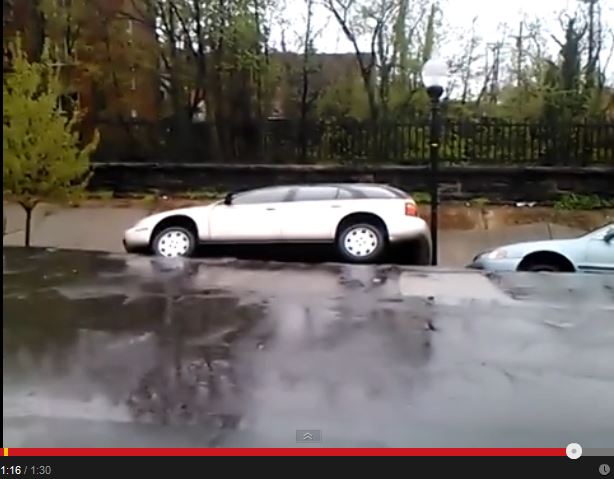
Two interesting aspects to highlight. First, if you watch the video the progressive development of the failure is evident. The car on the left develops an increasing tilt through time, which that on the right slowly subsides. This is a screenshot of the two cars at about 12 seconds from the start of the video:
..
And these is the same two cars just before the collapse:
 ..
..
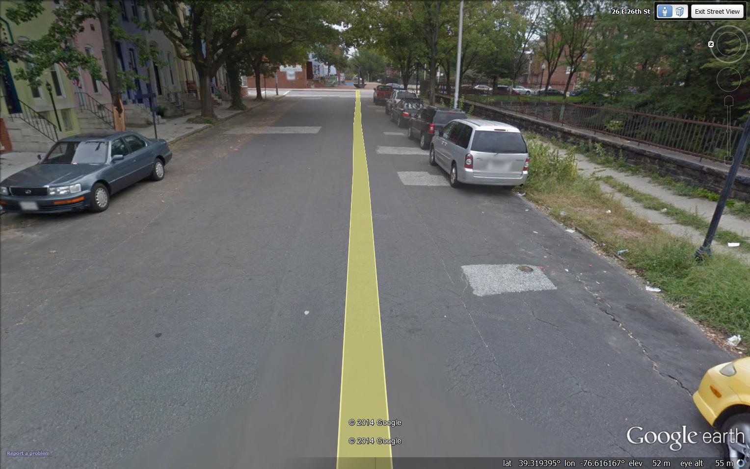
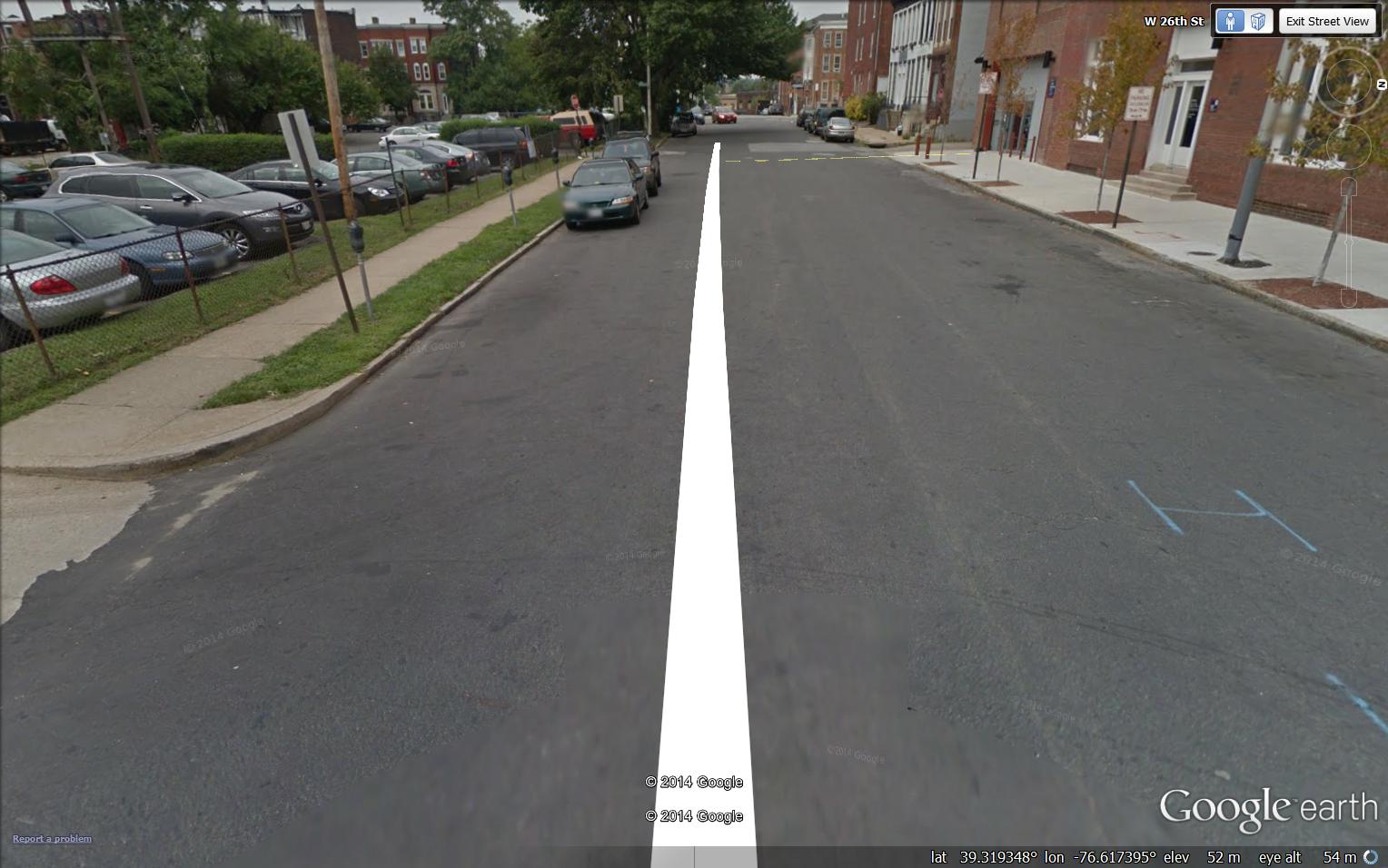
Second, the Google Street view image for the section of road that collapsed shows a very poorly maintained road surface with an interesting set of linear cracks running parallel to the retaining wall:
..
These linear cracks are not present to the east on the same street, even though the road surface is also poorly maintained. This section of course is not above the railway cutting:
 Dave Petley is the Vice-Chancellor of the University of Hull in the United Kingdom. His blog provides commentary and analysis of landslide events occurring worldwide, including the landslides themselves, latest research, and conferences and meetings.
Recent Comments