
5 May 2014
The Ab Barak landslide in Afghanistan – a foreseeable event?
Posted by Dave Petley
The Ab Barak landslide
At the site of the Ab Barak landslide in Badakhshan, Afghanistan, efforts to recover victims have now ceased, with the focus moving to the 4000 or so survivors, many of whom have been left destitute. There remains considerable uncertainty about the number of victims – sadly this is unlikely to be resolved – with estimates ranging from “over 300” to 2,700. With 300 houses having been buried, and a large number of additional people having entered the area after the initial landslide event, it is likely that the number lost will be at the higher end of the range (though hopefully not as high as 2,700).
Was Ab Barak foreseeable?
Determining the location of the Ab Barak landslide has been challenging, and I am grateful to Kerry Leath of TUM for figuring it out. He has an excellent blog post online about the site of the landslide, in which he has reconstructed the event in Google Earth. I’ll not repeat that here, but the site of the landslide on the Google Earth imagery (from 2004) is of interest:

..
The above image unfortunately crosses the boundary between two Google Earth source images, and of course the area of interest is just within the lower resolution area. The source of the landslide is the easily-identifiable, heavily gullied area just to the right of centre on the opposite side of the valley from the village. That this area was potentially unstable is easily identifiable from the imagery above – it would be even clearer on a higher resolution image or an aerial photograph. Thus, with a basic mapping programme the hazard could easily have been identified and steps taken to manage it. As with the Oso landslide in Washington, we have a foreseeable landslide inducing a disaster – in others words, for whatever reason (which may well be a failure to implement an appropriate study rather a failing on the part of the hazard managers), we have failed to identify and mitigate the hazard properly.
A landslide hazard identification and mapping programme in this highly landslide-prone area of Afghanistan would be far cheaper than the cost of this single landslide. Given that the expertise is readily available around the world to undertake this type of exercise, it is a folly that it is not being done. This of course applies in many other locations as well, as today’s landslide in Nepal also demonstrates.
The trigger for the landslide was a period of very heavy rainfall. Reliefweb has a rather nice map, generated with TRMM data, showing the total rainfall accumulation in the period 25-29th April:
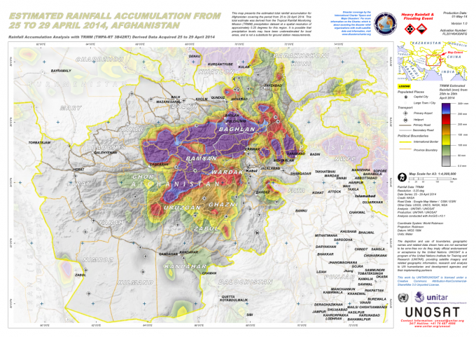
..
Kerry Leith notes that a lake is building up behind the landslide mass. He rightly notes that this represents a threat and needs to be managed.
Finally, there is some evidence that the is not the only significant landslide in Afghanistan in the last few days. Bilal Sarwary tweeted this image, from Mohammad Salem Wahdat, of another site, apparently also in Argo District:

Mohammad Salem Wahdat via Bilal Sarwary
..
That is a truly terrifying site. I have no idea of the context of this image (and cannot say for certain that it is from Argo District, though the materials and buildings look to me to reasonable for this area), but if this is an ongoing slide then the level of danger is obviously very high. The village is in effect already lost, being located on a displaced block. but I wonder what is downslope. Does anyone have any more information?
 Dave Petley is the Vice-Chancellor of the University of Hull in the United Kingdom. His blog provides commentary and analysis of landslide events occurring worldwide, including the landslides themselves, latest research, and conferences and meetings.
After spending two weeks in Gorno-Badakhshan in nearby Tajikistan Last Summer all I can say is that is appears this general area is incredibly unstable. (Some pictures from my trip, http://www.tiran-daz.com/Tajikistan.html) Villages in both countries have similar construction (rocks,mud and some wood) and are generally located in very precarious areas. I am not at all surprised to hear about this landslide. Of course having some sort of landslide warning system would be great, there are so many other problems (infrastructure, education, corruption, war) that I think it is often ignored.
I think the wisest thing the people can do is to either move to a location with a low risk of a landslide or become better educated with the signs of danger. However when you think that many of the villages are composed of groups that have more or less lived in the same region for perhaps even thousands of years It may be unlikely to see them moving out, although I think in Tajikistan there is a growing pull to take the younger children out of the villages and into the big city where they can get jobs and make money, im not sure if there is this pull in Afghanistan as well, although I know many have tried to make some money in Iran and then eventually return to their village. I guess it just depends on what the villagers want.
This map was very interesting to me when I was working in Afghanistan. I used it to help identify soil clasifications in Cha-i-Ab, Pul-e-Khomri, Arghanj Khaw and Fayzabad. Soils in Badakhshan are a mess. They change so much within a 2 mile radius. Hope this can help!
http://www.nrcs.usda.gov/wps/portal/nrcs/detail/soils/use/maps/?cid=nrcs142p2_054000