
31 October 2014
The Mannen rockslide: still standing
The Mannen rockslide – an update
The Mannen rockslide in Norway continues to confound predictions of its imminent demise, and as of this morning it remains intact. A press conference was held yesterday morning in which it was reported that the rate of movement had declined from over 4 cm per day to about 1.5 cm / day. Some rockfall activity continues to occur, but the major collapse is still some indeterminate time away. The live web cams continue to broadcast from the Mannen rockslide site, although the public comments express an increasing level of frustration amongst those taking an interest.
.The scientific effort for the Mannen rockslide is being led by Lars Harald Blikra of NGU. He is vastly experienced in rockslope monitoring – there is no-one better – and his team are using appropriate techniques to monitor the slide. However, the processes of detachment of large rock blocks are extremely complex and inadequately understood, so forecasting (and predicting) a collapse event is very challenging. The recent snowfall will not have helped the efforts to monitor the landslide, given that radar is a key technique being deployed. This graph, from Nyheter, shows the movement of the landslide over a 24 hour period earlier this week:

http://www.adressa.no/nyheter/moreromsdal/article10284793.ece
.
I suspect that the emergency management people are now in a very challenging situation. The continued movement of the slope will be edging it closer to failure, but it is not clear when this might occur. They will be anxious to reopen the railway line and to lift the evacuation order, but very cautious about the ongoing risks from the landslide. I am sure that they are hoping that it will just fail. I suspect that they will come under increasing pressure to try to fail the slope artificially – water bombers are being mentioned – but it will be very difficult to get enough water in the right place for this to be effective. Explosives could also be used, but emplacing the charges would carry a very high level of risk. Thus, this may continue to be a waiting game for the time being. I have no doubt that Lars and his colleagues are under great stress.
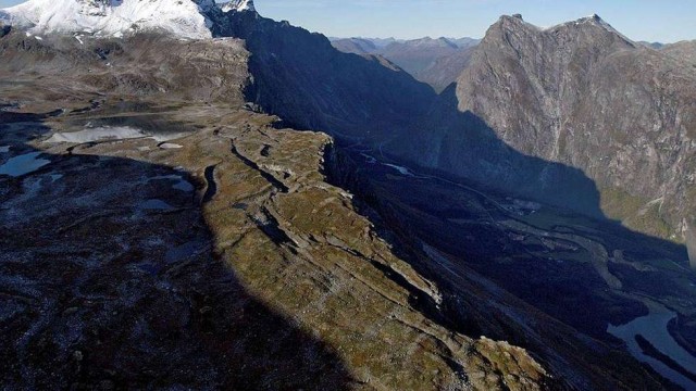
The currently active block is part of a much larger landslide at Mannen. This image from Nyheter shows the multiple fractures at the top of the slope:
http://www.adressa.no/nyheter/moreromsdal/article10265656.ece
.
This whole slope is moving, albeit at a much lower rate than the active block. Whilst there is no suggestion that the main slide will fail, the active deformation will have probably created a much more fragmented rock mass below the active slide. The failure of the active block will almost certainly cause more detachment of material downslope. That the downslope material is likely to be fragmented, and thus more easily entrained, explains the estimates that the final mobile volume may be in the order of 2 million cubic metres.
29 October 2014
Mount Mannen in Norway: an imminent large rockslide
Mount Mannen
Mount Mannen is located in Romsdal in the northernmost part of western Norway; Alesund is the nearest large city. Over the last few days much of Norway has been watching with fascination to see if a large rockslide will occur on the flanks of the mountain. There is sufficient interest in this event that there are live webcams broadcasting the events on the slope. The potential failure is in the order of 120,000 cubic metres, so the final collapse, should it occur, will be quite spectacular.
The issue is a large, actively deforming block high on the mountainside. This is being monitored in detail, and in recent days the block has started to accelerate, with further very heavy rainfall was due overnight (although no failure appears to have occurred). The VG.no website showed this graphic with apparent displacement data:

http://www.bt.no/nyheter/innenriks/–Fjellet-raser-trolig-ut-i-kveld-3228657.html
.
.
Whilst in one of the videos on the above webpage a plot was shown with data extending over a longer time frame (apologies for the poor quality of this screenshot)::
 .
.
This montage of photos in a VG.no article rather nicely shows the block that is causing concern – and in particular the second from right images shows the displacement across the crown of the landslide:
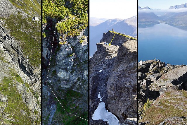
http://www.vg.no/nyheter/innenriks/rasdramaet-i-rauma/disse-fire-er-hoeyrisiko-fjell-og-overvaakes-hele-tiden/a/23324070/
.
There is also a very nice helicopter video of the slope, which shows why it is causing such concern.
There are very few articles in English on this landslide, but this one from yesterday provides an overview of the current situation. Note that the article was speculating that the failure would occur yesterday though, which did not occur. A more recent article describes quite well the profound difficulties of trying predict reliably these final collapse events, especially where the rockmass is highly fractured and disrupted. There is little doubt that this block will ultimately fail, but whether it will be in the current movement episode is hard to tell. Unfortunately of course if movement of the block slows down then the authorities will have major problems in managing the long term hazard. This is an event that is worth watching. Fortunately, it appears to be a nice clear day on Mount Mannen today, so the webcams have an excellent view of the slope.
23 October 2014
Riverbank collapse: a fascinating new video
Riverbank collapse
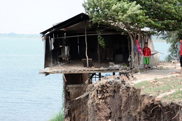
Riverbank collapse is a type of landslide that has probably been under-researched in recent years. Whilst such events cause few fatalities in the global scheme, the impact on infrastructure and property can be serious. A fascinating case study lies in the Mekong River – a problem that is so serious that in 2009 the Prime Minister of Cambodia warned about the threats of the “seasonal collapse of riverbanks”. Earlier this year a woman and two young children were killed by riverbank collapse in Kandal Province in Cambodia. This image, from the same article, is a nice illustration of the problem:
.
Over in Australia there is a very nice project in progress, in which I have some involvement, looking at riverbank collapse along the Murray River, where collapsing riverbanks were a major problem when the river level was very low in the drought of a few years ago. There is a very nice e-poster by the research team online explaining the provisional results of this work – NB this is a pdf.
Whilst the mechanisms of riverbank collapse might initially seem to be simple, they are in reality extremely complex, not least because the stress state is very dynamic due to the effects of water coming into the bank from the river, from the bank top and through the ground. In many rivers water levels rise and fall quickly, causing unusually rapid pore water pressure changes. And of course humans have an annoying habit of messing around with rivers, and riverbanks, too.
Anyway, there is an interesting video on Youtube, which I don’t think I’ve seen before, showing a riverbank collapse event. I am not sure where this happened.
http://www.youtube.com/watch?v=dEPsxaOuqa0
.
Clearly the river is in flood, but the complexity of the failure, and its progressive nature, illustrates how complex the mechanics can be.
22 October 2014
The Bukit Beruntung landslide in Selangor, Malaysia
The Bukit Beruntung landslide
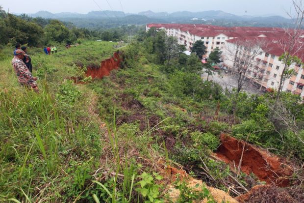
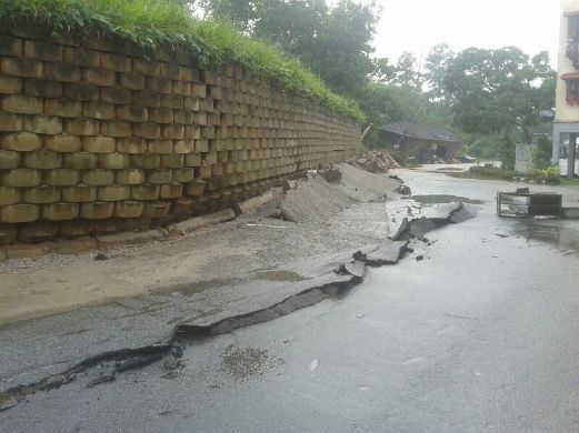
Bukit Beruntung is a relatively modern residential development in Selangor, Malaysia. On Monday morning heavy rainfall triggered movement in a slope behind some of the apartments, leading to the evacuation of over 2000 residents. Two days on, over 500 people are still out of their homes, although movement of the slop[e has slowed down. This is not a small slope failure – this image, from the Star, shows the slope from the crown area:
.
Of note here if the large displacement at the crown of the slope and the deep red colour of the soil, which indicates that it is highly weathered – typical for a tropical setting. A likely explanation for this slope failure is revealed by images of the toe of the slope, which show a heavily deforming retaining wall:
.
The deformation in the asphalt in front of the wall is interesting. Whilst this might indicate that the failure is passing beneath the wall, I think it is more likely that the wall is being shunted forward by the landslide, causing this deformation. Whilst in all probability this slope can be easily fixed, it is not going to be a trivial task.
20 October 2014
2015 AEG Shlemon Specialty Conference – “Time to Face the Landslide Hazard Dilemma: Bridging Science, Policy, Public Safety, and Potential Loss”
.
2015 AEG Shlemon Specialty Conference
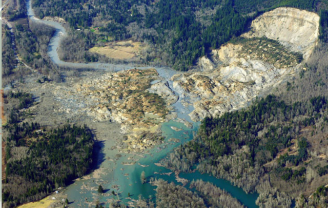
The 2015 Shlemon Specialty Conference, organised by the Association of Environmental and Engineering Geologists, is entitled “Time to Face the Landslide Hazard Dilemma: Bridging Science, Policy, Public Safety, and Potential Loss”. It is being held in Seattle from 26th to 20th February 2015 to mark the 1st anniversary of the Oso landslide disaster. The website description of the meeting is as follows:
The conference will consist of two days of technical and other presentations by invited speakers, posters, discussion sessions and workshops regarding: landslide hazard assessment and risk methodology, current state and local programs and how these can be integrated into current and potential future national programs, what’s working and where do we need to improve, can we develop consensus recommendations and guidance for agencies responsible for land use, and more. There will also be an optional field trip to the Oso landslide and another recent landslide impacting several houses in Everett, WA on Saturday.
Details of the 2015 Shlemon Specialty Conference are available as a pdf at:
http://www.aegweb.org/docs/default-source/events/shlemon_2015.pdf?sfvrsn=2
15 October 2014
Three great new landslide videos, including a surfing backhoe!
A surfing backhoe
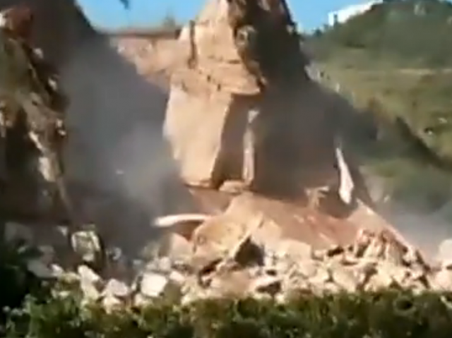
The first of these three new landslide videos is a really interesting film of a small landslide taking out a backhoe:
http://www.youtube.com/watch?v=03N1364FPIY
.
This seems to be a nice example of a slide triggered by excess loading at the crest of the slope – in this case the backhoe itself. The slide is small, only removing the land on which the excavator is standing. Note the high mobility of the slide once it starts though. It is interesting to note that the backhoe remains upright. The sliding surface is clearly visible at the end of the video – a beautiful illustration of the way that a clay-rich soil can form a low friction sliding plane.
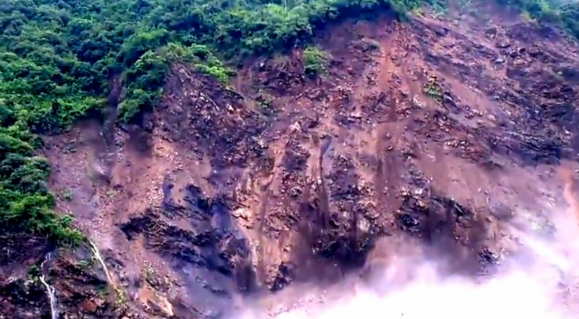
A large landslide in Taiwan
This video is over a year old, but I’ve not seen it previously as far as I’m aware. This is probably one of the highest quality videos of a large-scale landslide that I’ve seen to date:
.
The most interesting aspect of this slide is the precursory activity that occurs across the slope before the main collapse event. It would be really interesting to map this in time and space. This is I think an indication that the whole block is moving, which as a result is deforming, popping off the smaller failures. Just before the main collapse small rockfalls and landslides are occurring across the whole slope, as this image shows:
.
A soil slide from Indonesia
Finally, this landslide video appeared on Liveleak yesterday:
.
It was reportedly collected in Manado in Sulewesi in Indonesia. Again, the slope shows lots of precursory landslide activity before the main failure event. Shortly before the failure a man walks along the road that was subsequently inundated; I wonder whether he managed to escape. It is interesting to note that the main slide appears to then trigger a second failure on a different part of the slope. It is not clear to me why this should have occurred.
9 October 2014
China: a new rockfall video from Guiyang, Guizhou and images of landslides from the Yunnan earthquake in August
A rockfall in Guizhou
One News in New Zealand has an interesting news report including a video of a rockfall event along a highway in Guiyang in Guizhou Province. The video is embedded from Youtube below, which includes a nice set of images of the aftermath and replays the collapse event several times.
http://www.youtube.com/watch?v=wAP2oQLLUh4
.
Fortunately the potential for collapse had been identified and the road had been closed. The collapse event appears to have happened on a pre-existing basal release surface and to be defined by a set of existing vertical joints – i.e. in essence this is a complex wedge failure, as this screenshot shows:
.
This collapse is the result of a failure to properly assess the discontinuities in the rock mass during construction. Such events should be avoidable with proper engineering geological assessment and mitigation.
Images of landslides from the Yunnan earthquake
Meanwhile, Getty Images has a gallery showing landslides triggered by the 5th August 2014 earthquake in Yunnan Province. I cannot include them here, they are worth a look if you get a chance. Earlier this week six members of a team trying to drain one of the valley-blocking landslides were killed when the dam rapidly failed. A further 2000 people had to be evacuated.
8 October 2014
The current state of the Sunkoshi landslide in Nepal
The Sunkoshi Landslide
After the breach and the reconstruction of at least a rudimentary road, the Sunkoshi landslide in Nepal has dropped off the radar screen. Inevitably though the legacy of such an event lives on. An interesting insight into the state of play can be gleaned from a blog post put up by the “This World Ahead” team, two German nationals who are undertaking a 15 month long round the world motorbike tour. They reached the landslide this week and put up a blog post about it yesterday, with some very high quality images. The pertinent section of the post says:
“After crossing the Chinese-Nepalese border in the north of Kathmandu we where facing the incredible dimension of the recent landslide. Tons of rocks, sand and mud, disrupting the green jungle. The massive slide, now calmly lying in the valley, tore a huge hole into the mountain, as if a giant had turned over the earth cover with a shovel and buried hundreds of people under it. It took us approximately four hours and hard work to pass the provisionally, three kilometers long path over the landslide.”
I have reproduced two of the images below. The first shows the landslide itself:
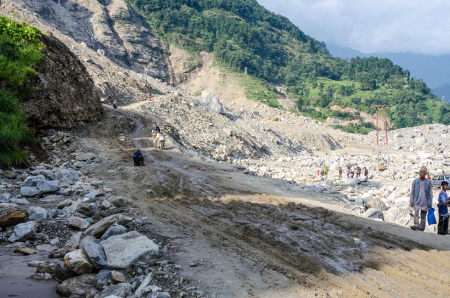
http://thisworldahead.com/2014/10/07/along-the-way-the-nepalese-landslide/
.
Note the state of the track on the foreground. This image shows the track itself:
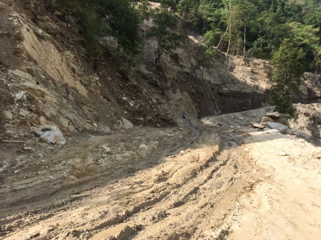
http://thisworldahead.com/2014/10/07/along-the-way-the-nepalese-landslide/
.
The fact that it took four hours to get two trail motorbikes a distance of three kilometres over the landslide, and the lack of vehicular traffic apart from motorbikes in the images, is very informative about the state of play at the landslide site. The impacts on the livelihoods of the population in this area must be profound.
7 October 2014
Landslides in the movies part 1: The Croods
The Croods
I thought it would be interesting to run an occasional series showing how landslides have been depicted in the movies and on television. The first example I came across comes from The Croods, a Dreamworks animated film that was released last year. The plot of the film is described here, but a key scene is one in which the family is forced from their home by a large rockfall. This almost kills them, but of course they have a miraculous escape. The rockfall sequence appears in the trailer at about 1 minute 20 secs:
.
The animation is pretty good. The main collapse is preceded by some precursory small rockfalls (and the father of the family correctly deduces from this that a collapse is imminent – perhaps the first example of a landslide warning system? The main collapse event looks a little strange – in particular it is hard to see how the mass that is seen falling at 1 min 29 secs could release kinematically:
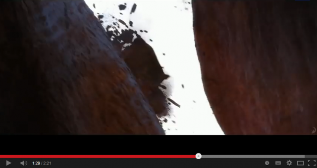 .
.
But the fragmentation that is occurring around the block is really good, as is the brief scene in which the mass is impacting on the floor of the canyon, with really nice capture of rock fragmentation on impact. Somehow on the way down the large mass seen above appears to have fragmented though, which seems a little odd:
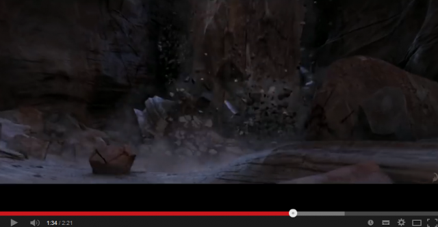 ..
..
The rockfall generates a blast wave and dust cloud that envelopes the family, which is also well handled.
Suggestions for subsequent parts of this series are welcome.
6 October 2014
Fatal landslides in the first seven months of 2014
Fatal landslides in the first seven months of 2014
I have now analysed the data on fatal landslides (i.e. those that caused loss of life) for the first seven months of the year. This is the dataset that I’ve been collecting since 2002 (i.e. for over 12 years), and that I wrote up for my paper in Geology a couple of years ago (Petley 2012). This map shows the distribution of the landslides for the period January to July 2014
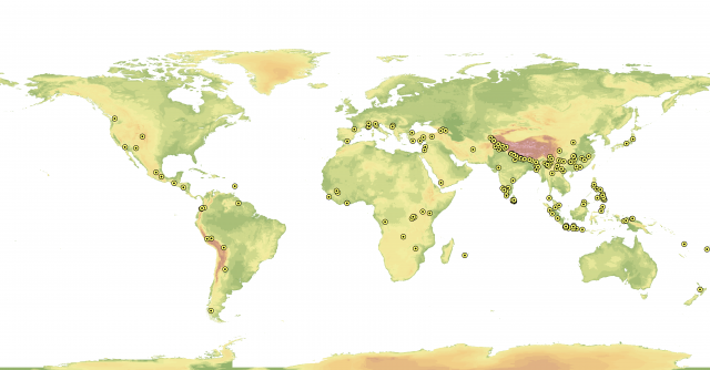
Each dot represents a single landslide that killed at least one person; there is no representation of how many people were killed in each event. The background image is a digital elevation model. As usual the map shows hotspots in South Asia, China, Indonesia and the Philippines, plus a scattering of landslide events elsewhere. There are slightly more landslides in Africa than normal.
In this seven month period I recorded 222 landslides that caused loss of life, resulting in 1466 deaths. The largest event occurred in Afghanistan in May, with about 500 deaths (although early reports suggested many more). The average number of landslides in the first seven months of the year for the period 2003-2013 is 202, so at a little over halfway 2014 is slightly above average. At the same point in the last few years the totals were:- 2010: 303; 2011: 214; 2012: 220; 2013: 237. Of course the severity of the year in terms of landslides is defined by the period July to September, so I will need to analyse the more recent data to be able to determine this.
The fatality data shows much more inter-annual variation, but the average over the period 2003-2013 is 2318 lives lost, so in this respect 2014 is less severe than the previous decade or so.
Reference
Petley, D.N. 2012. Global patterns of loss of life from landslides. Geology 40 (10), 927-930.Petley, D.N. 2012. Global patterns of loss of life from landslides. Geology 40 (10), 927-930.
 Dave Petley is the Vice-Chancellor of the University of Hull in the United Kingdom. His blog provides commentary and analysis of landslide events occurring worldwide, including the landslides themselves, latest research, and conferences and meetings.
Recent Comments