
11 February 2021
High resolution Planet Labs imagery of the Chamoli landslide in Uttarakhand
Posted by Dave Petley
High resolution Planet Labs imagery of the Chamoli landslide in Uttarakhand
Planet Labs has very kindly captured a set of high resolution SkySat imagery of the Chamoli landslide, which they have made available to the research community. Once again I must note my appreciation and thanks for this – it is invaluable. The dataset is so rich that I hardly no where to start with it; at this stage I don’t really have a plan as to how I will post it here. But a good place to start is with the block that detached to create the disaster.
I must also add here that all my interpretations on this blog are initial – they are not intended to be definitive. Proper peer reviewed papers will follow; I hope that I will be involved in some of them. They will provide the definitive story. My posts here are intended to provide an initial interpretation and to give insight into how our thinking evolves over time. As with previous posts, I will seek to correct the posts as new information becomes available.
This is the a Planet Labs SkySat image of the landslide source (part of a much larger image). The image is fantastic, and alongside the Pleaides image that is also available, it gives a really clear impression of what has happened:-
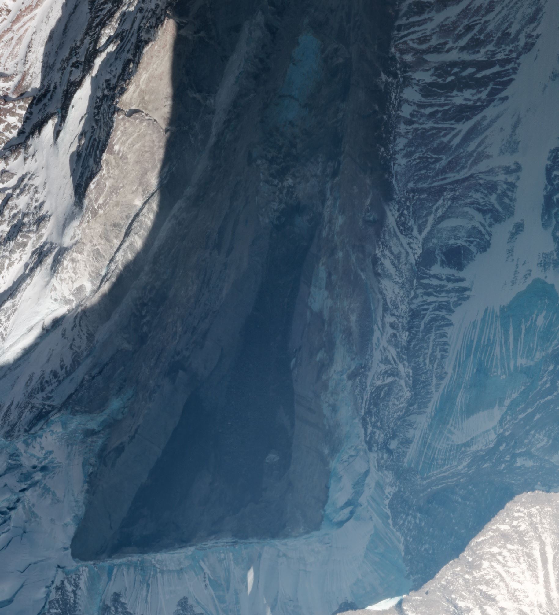
Planet Labs SkySat image of the Chamoli landslide in Uttarakhand. Copyright Planet Labs, used with permission.
.
For orientation, the valley floor is to the north, and the block that has dropped off is about 550 m wide. This is a very steep slope, so the block is very large indeed.
My interpretation is that this is a wedge failure – note the inclined surfaces on the east and west side, although the basal shear plane (the darker rock in the image) may be another, slope parallel, joint. The block has dropped out of this wedge-shaped source, and fallen almost vertically about 1800 metres.
It is interesting to compare the image above with one from the days before the collapse. The image below of the site of the Chamoli landslide was captured by Planet Labs using their lower resolution PlanetScope instrument on 30 January 2021:-
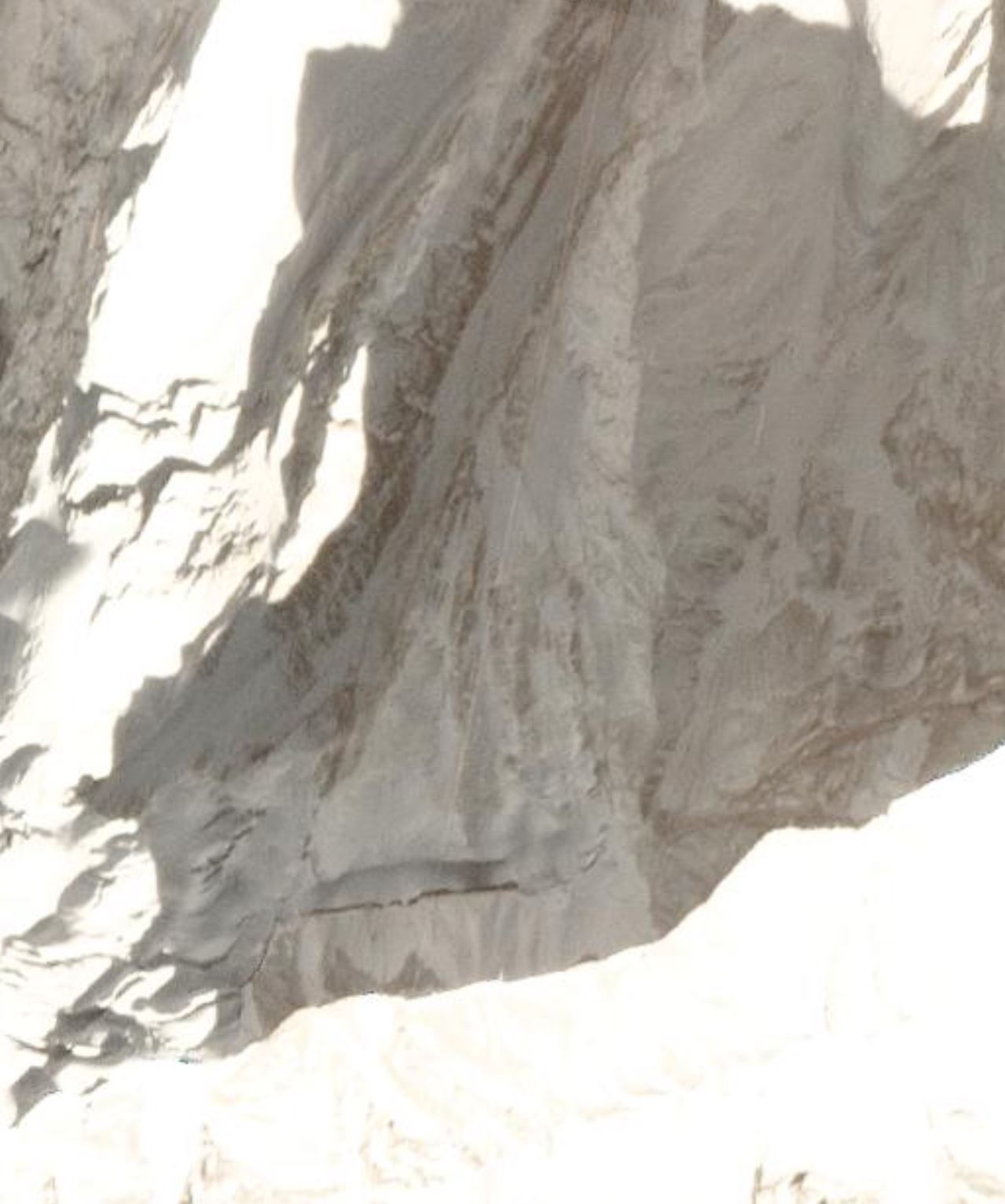
Planet Labs PlanetScope image of the site of the Chamoli landslide in Uttarakhand. Copyright Planet Labs, used with permission.
.
A couple of things to note here. First, a large tension crack at the crown of the landslide is clearly visible in the January image. To have been captured on imagery with a 3 m spatial resolution means that this was a really substantial feature. Second, whilst there have been some suggestions that this was a hanging glacier. There was some thick ice in the upper reaches, but I don’t believe that this could be described as a hanging glacier. Further down the slope, on the block that failed, bare rock is visible.
Thus, I continue to believe that this is the failure of a rock block not of a hanging glacier. It is a landslide not a glacial event, in my opinion at this time.
Reference
Planet Team (2021). Planet Application Program Interface: In Space for Life on Earth. San Francisco, CA. https://www.planet.com/
 Dave Petley is the Vice-Chancellor of the University of Hull in the United Kingdom. His blog provides commentary and analysis of landslide events occurring worldwide, including the landslides themselves, latest research, and conferences and meetings.
Thank you for sharing Prof Petley. Fabulous example showing evidence of pre-failure although in this case so remote few will have noticed and of course it does not give much clue as to the timing of failure without monitoring. Nevertheless, noticing features of pre-failure of slopes and acting on them by those in authority can certainly save lives but not in this case.
Best regards,
Prof Roger Moore
Dear Dave,
Thank you for providing us with extremely interesting material regarding the Chamoli landslide!
I agree that the detachment mechanism most probably is a wedge failure. However, if the darker rock in the image is a basal shear plane, the intersection line of the inclined surfaces on the east and west side must be steeper than the basal plane, which seems to be not very probable. Furthermore, if the darker rock in the image is a basal shear plane, it would not be a wedge sliding on the inclined surfaces on the east and west side, but it would be a block sliding on the basal shear plane detaching from the inclined surfaces on the east and west side. Thus, I think it was a wedge sliding on the inclined surfaces on the east and west side and detaching from the darker rock and from the rock south of the large tension crack at the crown of the landslide.
It would be interesting to use a pair of images for determination of the orientations of all discontinuities and free surfaces involved in this failure.
What do you think?
Best regards and all the best
Rainer
Thanks to everyone and the satellite companies for making these amazing images available. From an initial look at the Pleiades image acquired on 9th Feb (processed by S. Gascoin & E. Berthier), I have identified what I believe to be crossing oblique joint sets, if not faults. The failure appears to me to have been a wedge failure in bedrock on which there might have been a small amount of residual glacier ice + snow but not enough to constitute a hanging glacier. This was predominantly a failure of the bedrock bounded by geological structures. The area is riddled with them; I have as yet only picked out several. What is also pertinent is that the upper reaches of this back wall and the ridges around are all highly fractured. This suggests that there could be many more equally if not larger failures in the future. These hazards should have been identified during pre-feasibility studies for the HPP schemes downstream.
Supporting your idea that this is a primarily a landslide, and secondarily a glacier collapse, there is a visible trend line on both sides of the head scarp. On the image-left side, looks like it could just be crevasses. On the image-right side, it looks like a discontinuity in the bedrock.
I offer a broad 3d perspective at :
https://sketchfab.com/3d-models/glac-354a5b8fdbaa4d8ea62fa4ad27285915
There are thousands of opportunities for such slides throughout the area and also in The Andes. They are part of the process of active mountain building and usually have little or no connection with dam building or greenhouse gases. Road construction could be a trigger in some cases. Also seismicity.
I suspect there could be some linkage of this rock fall with global warming. Global warming has resulted into retreat of snowline upwards, thinning of ice and snow layers, increased erosions / debris flow at the bottom/ base/ foundation of the mountains due to melting of permafrost. These processes could have enhanced and increased the rock slides resulting in to larger and frequent falls than the natural process. Regarding to timing, I assume the rock fall could have generated large tremor in the area which could be captured by one of the nearest seismic stations that will provide information about the time of the fall.
More VHR imagery here https://labo.obs-mip.fr/multitemp/pleiades-images-of-the-uttarakhand-disaster/
Btw it’s Pléiades not Pleaides
Wonderful film and video on this terrible event. Also very fascinating analysis.