
5 January 2021
Planet Labs high resolution satellite image of the Gjerdrum landslide in Norway
Posted by Dave Petley
Planet Labs high resolution satellite image of the Gjerdrum landslide in Norway
Operations continue with some intensity of the site of the Gjerdrum landslide in the village of Ask in Norway. Sadly, the focus has now changed from rescue to recovery, with an acceptance that there are no more survivors. To date the remains of seven victims have been recovered, leaving three people missing. Operations have been made easier by an improvement in the conditions on the landslide, but finding those still missing will be a difficult task.
My friends at Planet Labs have now managed to capture an excellent SkySat high resolution satellite image of the site – once again can I note my thanks to them, and in particular to Rob Simmon, for their support. This is the first image that I have seen of the entirety of the site.
The crown of the landslide is of course where the losses occurred. The image below shows this area:
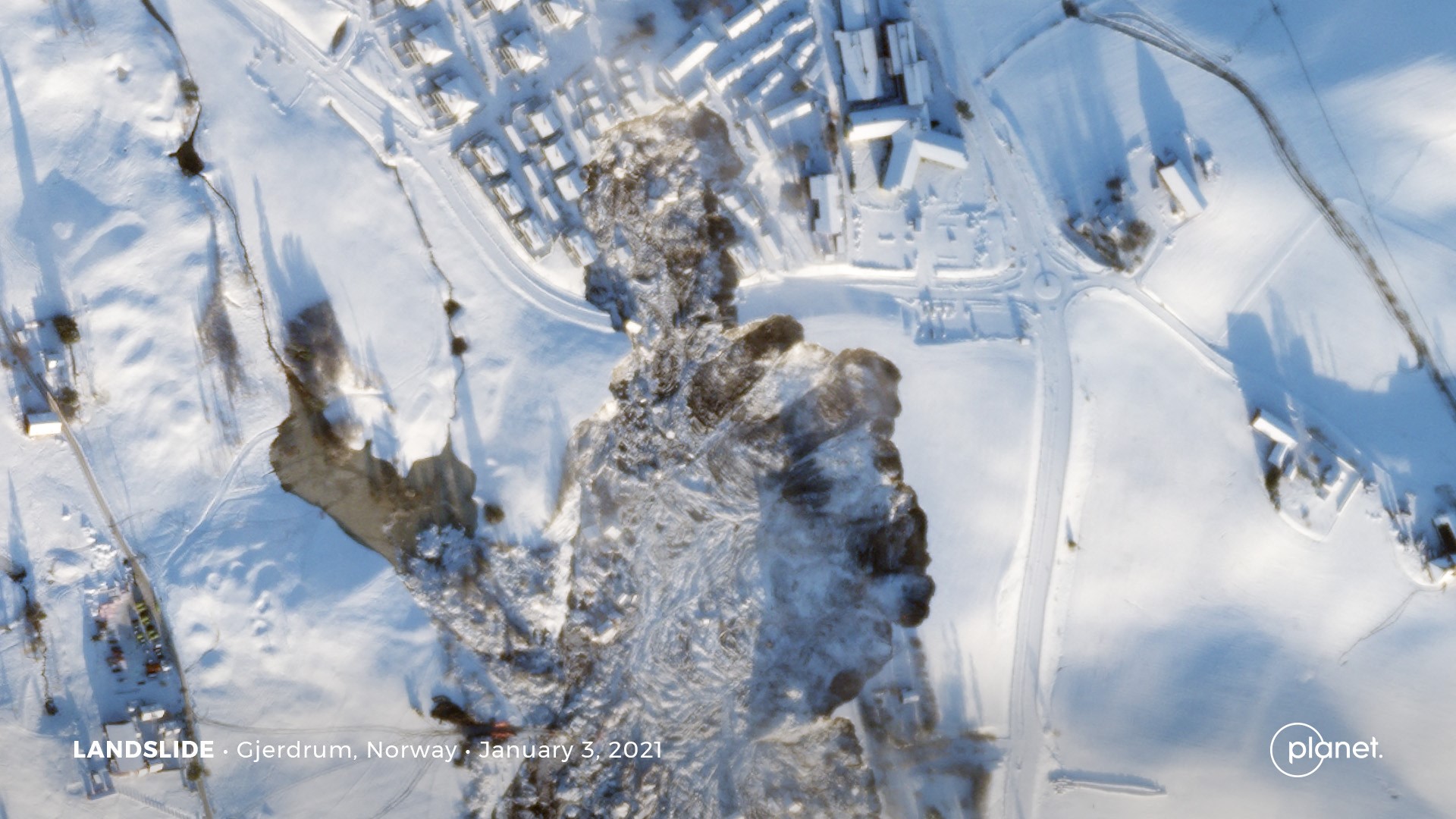
A high resolution SkySat satellite image of the Gjerdrum landslide in Norway. Image Copyright Planet Labs, used with permission.
.
The form of this landslide is interesting, with a large main source area, and a smaller area to the north that has affected the houses with such catastrophic consequences. The reason for that morphology is not clear to me – on first inspection it appears that this was a retrogression from the main landslide bowl. If so, it will be important to understand why this happened at this particular location. Others will be better placed to comment on this than me, and I’m sure that the official investigation will provide an explanation.
The Planet Labs image also captured the whole of the landslide, which is very large. This is the image:-
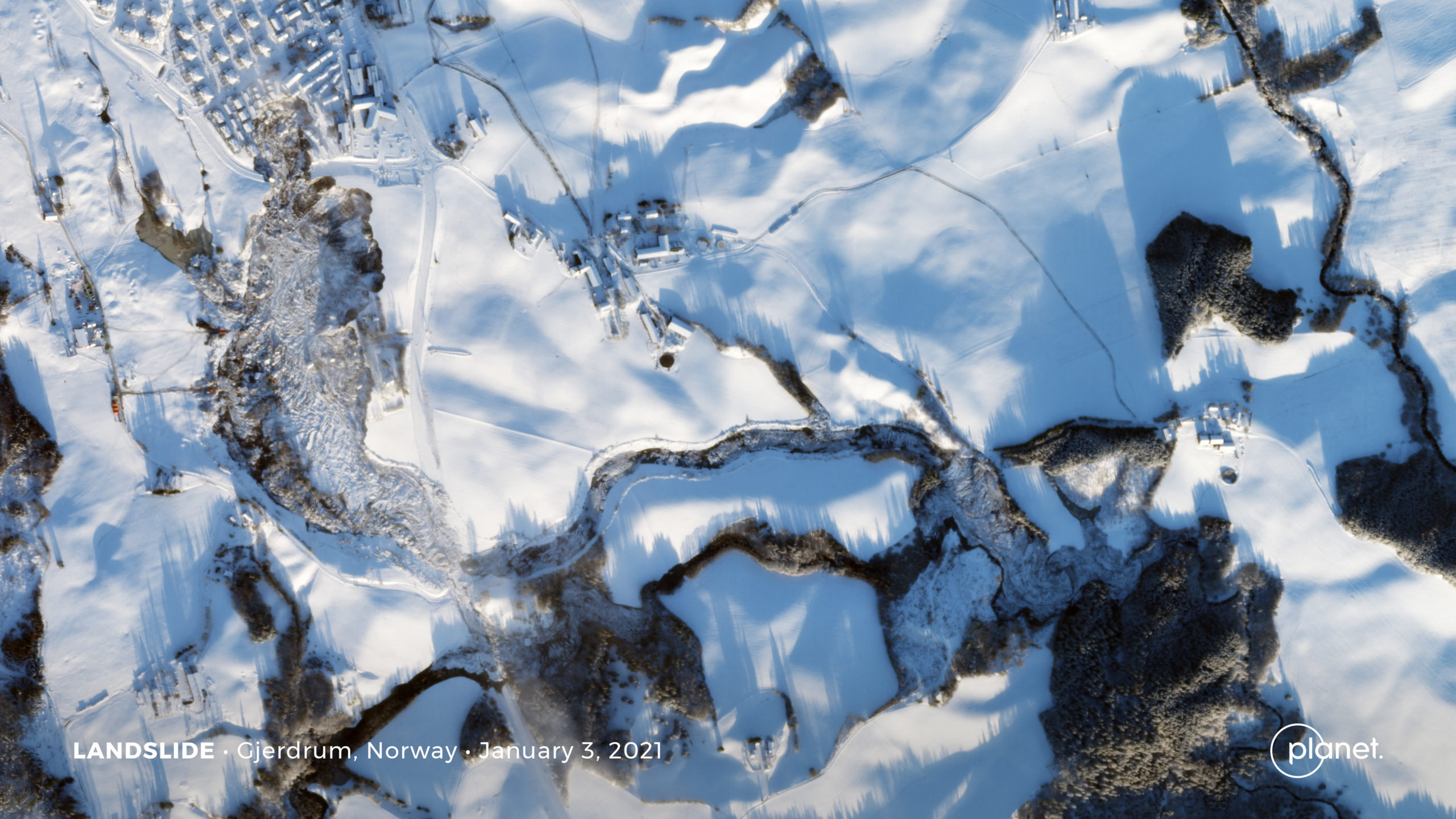
A high resolution SkySat satellite image of the Gjerdrum landslide in Norway. Image Copyright Planet Labs, used with permission.
.
Note the main source on the western side of the image. The main slide moved roughly towards the south, and then followed a very subtle channel towards the east. Mobility was high – the choked channel on the eastern side of the image demonstrates that the landslide moved over 2 2 km. In one location the slide has bifurcated, as seen on the helicopter image. There is a very substantial amount of debris at the toe of the landslide.
There is a great deal of speculation about the trigger of the Gjerdrum landslide. In the past, for example at Rissa, quick clay landslides have been triggered by excavations lower on the slope, which induced rapid liquefaction and expansion of the landslide. There is also some discussion about the role of modification of the topography too – the slope included both a golf course and the housing development. I am not in a position to comment on this, but the Wikipedia article on the Gjerdrum landslide has some details.
Reference
Planet Team (2020). Planet Application Program Interface: In Space for Life on Earth. San Francisco, CA. https://www.planet.com/
 Dave Petley is the Vice-Chancellor of the University of Hull in the United Kingdom. His blog provides commentary and analysis of landslide events occurring worldwide, including the landslides themselves, latest research, and conferences and meetings.
A tragedy that will be repeated many times as we have built on deep soils that were deposited over rock hundreds of years ago.
However, I just wondered if you still think that it is possible to “create gravity” in a spaceship?
Spinning it will not help….
[I have no idea why you are asking this question on a blog about landslides. D.]
Dear all,
Here is a quick work I have done on this event using two orthorectified pairs of ascending and descending radar images acquired by Sentinel-1 on 24 and 30 December:
https://www.sentinelvision.eu/gallery/html/0b10b2cf00ef4a358b053c02c002aeeb
Best regards,
Guillaume
Thank you for these pictures!
NRK (the main national TV) published some pictures of the creek in the bottom of the valley (link below), in the southern part of what became the main landslide bowl. The creek went from north to south, partly in the open, partly in pipes. The land-owner took these picures in 2011, during and after an episode of strong rainfall, as he was worried about the increase of water in this creek and the capacity of the pipe. He/she wrote two letters to the municipality about this, including “…from being a humble creek that received runoff from the drainage of the fields as well as runoff from a few houses, it has become a river that gets “shock loads” of urban runoff from large built-up areas” (sorry for my bad translation). The hand-writing on one of the pictures say “I assume that the municipality now understands the gravity of the situation”.
https://www.nrk.no/norge/flere-varsler-om-bekken-i-skredomradet-1.15311870
As this type of landslide is retrogressive, the shape of the landslide seems to indicate that the initial failure may have occurred at the level of the road to the south-east of the area. Could the sudden rupture of a drain pipe under the road (from the pound West to the natural creek East), or just a leak, during heavy rainfall, have produced enough stress to trigger the landslide? A lead to investigate…
Excellent radar work!
I watched the helicopter recon video with Google Earth on another screen and approximated the track that way.