
1 July 2020
Dawn of Hope: a major peat landslide in County Leitrim, Republic of Ireland
Posted by Dave Petley
Dawn of Hope: a major peat landslide in County Leitrim, Republic of Ireland
Exceptional rainfall on Sunday 28 June 2020 triggered a major landslide at Dawn of Hope in Count Leitrim in the Republic of Ireland. This is an unusual landslide – the failure of a peat bog. Peat bog landslides are remarkable for their mobility and for the damage that they can cause.
The Irish Farmers Journal has a report about this event, which has seen the failure of a large area of peat bog and deposition on a large area too. The location is 54.201, -8.086 if you wish to take a look.
The best understanding of this remarkable failure can be gained from a series of three drone videos posted to Youtube by Garadice 2000. The best overview can be gained from the second in the series, which at the end appears to provide a view of the source area of the landslide:-
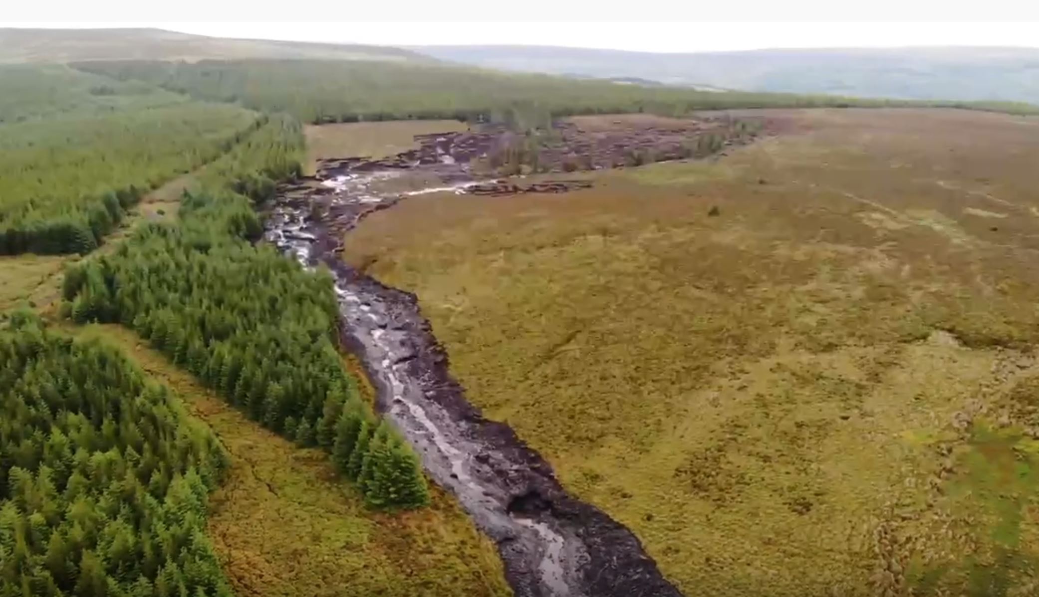
The source area of the Dawn of Hope landslide in County Leitrim. Still from a video posted to Youtube.
.
.
Meanwhile the video in the following tweet provides a really good impression of the long track of the landslide:-
Drone footage shows the cumulative effects of wide scale plantation @coilltenews forestry at the Dawn of Hope Bridge bog slide in Drumkeeran No EIA on any plantation in #Leitrim to date & almost 20% of the total county planted. It is having a MASSIVE environmental impact pic.twitter.com/9aC0yIsILJ
— Edwina Guckian (@EdwinaGuckian) June 30, 2020
.
The landslide has caused extensive damage downstream. This image, from the Irish Farmers Journal, shows the inundated area:-
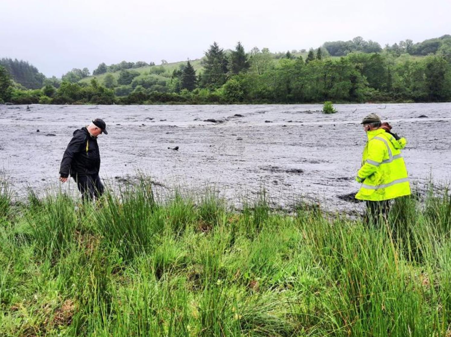
The area inundated by the Dawn of Hope landslide in County Leitrim. Image by John O’Hanlon IFA, via the Irish Farmers Journal.
.
Quickslide 1: The Old Fort landslide has slowed
The Old Fort landslide in Canada has slowed considerably, with a reported movement rate of about 10 cm per hour. Unfortunately, heavy rainfall is forecast for the next few days.
.
Quickslide 2: More heavy rainfall in China
China has once again issued a rainfall warning, this time for the regions of Sichuan, Chongqing, Guizhou, Yunnan, Guangxi, Fujian and Zhejiang. Over 12 million people have been affected so far.
 Dave Petley is the Vice-Chancellor of the University of Hull in the United Kingdom. His blog provides commentary and analysis of landslide events occurring worldwide, including the landslides themselves, latest research, and conferences and meetings.
Hi Dave,
There is a lot going on here, none of it surprising. The final seconds of the second ‘Garadice 2000’ video show the source area to be occupying a gentle topographic hollow, i.e. more than likely infilled with slightly deeper peat than surrounding slopes and ridgetops. Almost all Irish blanket bogs that I have investigated – many! – are predominantly (below about 0.5-1.0 m depth) characterised by fully amorphous matrix with varying proportions of (mostly fine) fibres and overall shear strength in the order of 2 to 4 kPa. Furthermore, the latest Google Earth imagery (11 April 2020) indicates the possibility of cut drains (linear features on the image) controlling the ‘left’ (video view) side of the source area. The scenario of heavy rainfall following a prolonged very dry period of weather is a common failure context for upland Irish peat failures. Likewise unsurprising is the likelihood of numerous drainage ditches through the forest (uphill from the source area) feeding excess runoff into the shallow basin from which the peat has moved. Comparing the video with the GoogleEarth image suggests that the source area may be up to 400 m long and in places up to 200 m wide. Peat 3 m deep or possibly a little more would not be surprising in this topographic context, so the volume of failed peat could be only a little short of 200,000 cubic metres or about 20,000 tonnes of solids. Of course, not all of this has left the source area and other blocks of peat may have been entrained by erosion further downstream, but this is still a substantial and clearly damaging quantity of material. Aside from possible damage to the road bridge and inundation of agricultural lands, a further consequence of this failure could be large scale loss of fish stocks further downstream due to the polluting effects of the colloidal peat debris (also observed in previous instances).
Hope others may find some of this useful.
Best wishes,
Alan
There’s another video (small in dimensions, sadly) showing more detail of the source area: https://video-den4-1.xx.fbcdn.net/v/t42.9040-2/10000000_370804927227584_6509195787704732790_n.mp4?_nc_cat=109&_nc_sid=985c63&efg=eyJ2ZW5jb2RlX3RhZyI6ImxlZ2FjeV9zZCJ9&_nc_ohc=WiRe8VcPz6wAX8K5KDc&_nc_ht=video-den4-1.xx&oh=902e45d3fcf484f29d7837706395d119&oe=5EFCE41A
Hi Dave, I’ve been collating a database of these for the last 20 years, and there are approaching 200 peat failures across the UK and Ireland between the 1700s and today. Bog bursts (retrogressive failures in relatively deep peat) are largely an Ireland / Northern Ireland phenomenon occurring in deeper peat, whilst peat slides (more like large tabular debris slides) are the dominant type in England, Scotland and Wales (though they also occur in large numbers in Ireland / Northern Ireland). On some hillsides in Ireland, there are several failures visible around the sideslopes and there is clear evidence that they occurred at different times (sometimes several decades apart). Most upland wind farm projects have to assess for their occurrence in the EIA stage of application, so they’re fairly well recognised as a hazard.
Another drone video has come to light that starts at the head of the source area and follows significant sections of the 7 km runout track (mostly the upper part to just downstream of the first bridge, then from the inundated floodplain to the downstream limit of inundation, with excellent quality footage of relevant details:
https://www.youtube.com/watch?v=ttJsyGSBPcc
Dave
The landslide started / originated in the centre of a sitka spruce plantation .
The mounding and channels would have greatly contributed to the event .
John Flynn s drone video gives great clarity .
You all seem to actually know what you’re talking about; is it reasonable to say that foerstry has exacerbated the existing problem of peatbog landslips? Is there any connection whatever with grouse moors and heather burnoff which some argue worsens annual flooding by draining water rapidly, whereas (it is argued) forestry would retain more of the water and release it more slowly?
Hi all, im researching this topic and cant seem to figure out how it happend in the first place and what were the key parts of information in this!