
22 April 2020
Zongling: an area of intense landslide activity in Guizhou Province, China
Posted by Dave Petley
Zongling: an area of intense landslide activity in Guizhou Province, China
A very nice, open access paper (Wang et al. 2020) has just been published in the journal Landslides exploring a new technique for the analysis of InSAR data for measuring the deformation of mass movements. As I have noted previously, InSAR is one of the most exciting areas of landslide science at the moment, providing the opportunity to both detect potentially dangerous slopes and to monitor their movement remotely. Wang et al. (2020) describe a new approach, an improved Interferometric Point Target Analysis (IPTA) method, to analyse these complex datasets, demonstrating that for the study sites at least it is able to provide detailed information about the behaviour of the slope.
The site for this study is Zongling in Guizhou Province, China. The article describes a very interesting set of landslides – the location is 21.718, 105.265 – go and take a look on Google Earth:-
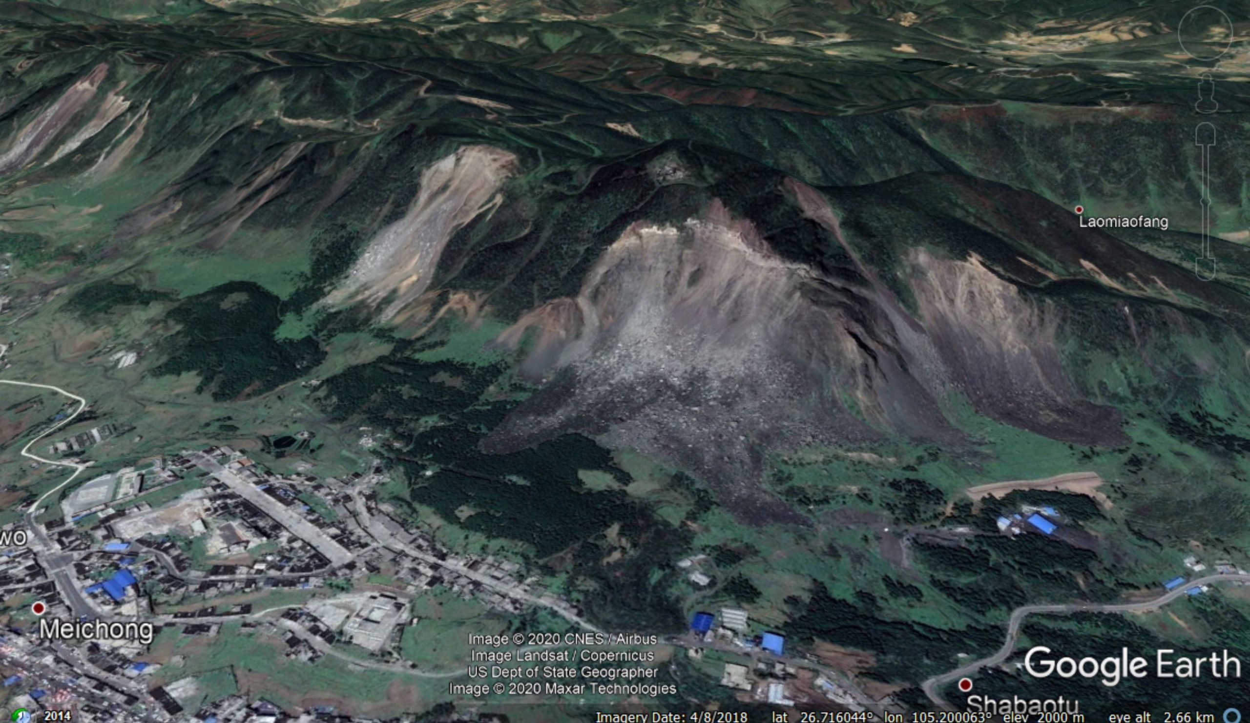
Google Earth image of the landslides at Zongling in Guizhou Province, China.
.
This ridge with multiple landslides consists of interbedded limestones, siltstones and mudstones, with a thick layer of limestone towards the crest of the slope. Wang et al. (2020) note that failure occurs as a result of the collapse of these thick limestone layers, which then induces movement and entrainment of materials below. As the image shows, these collapses have come perilously close to the town.
Whilst one’s eye is drawn to the section of slope in which collapses have already occurred at Zongling, the authors’ attention is on the unfailed portions of the slope. In the paper they demonstrate that there is substantial levels of movement across much of the slope. The InSAR data shows that the slopes creep continuously, but that accelerated periods of deformation occur in periods of heavy rainfall. The graphs below show the movement history of three areas of active deformation, plotted along with the precipitation, which appears to show that more movement occurs in periods of heavier (seasonal) rainfall::-
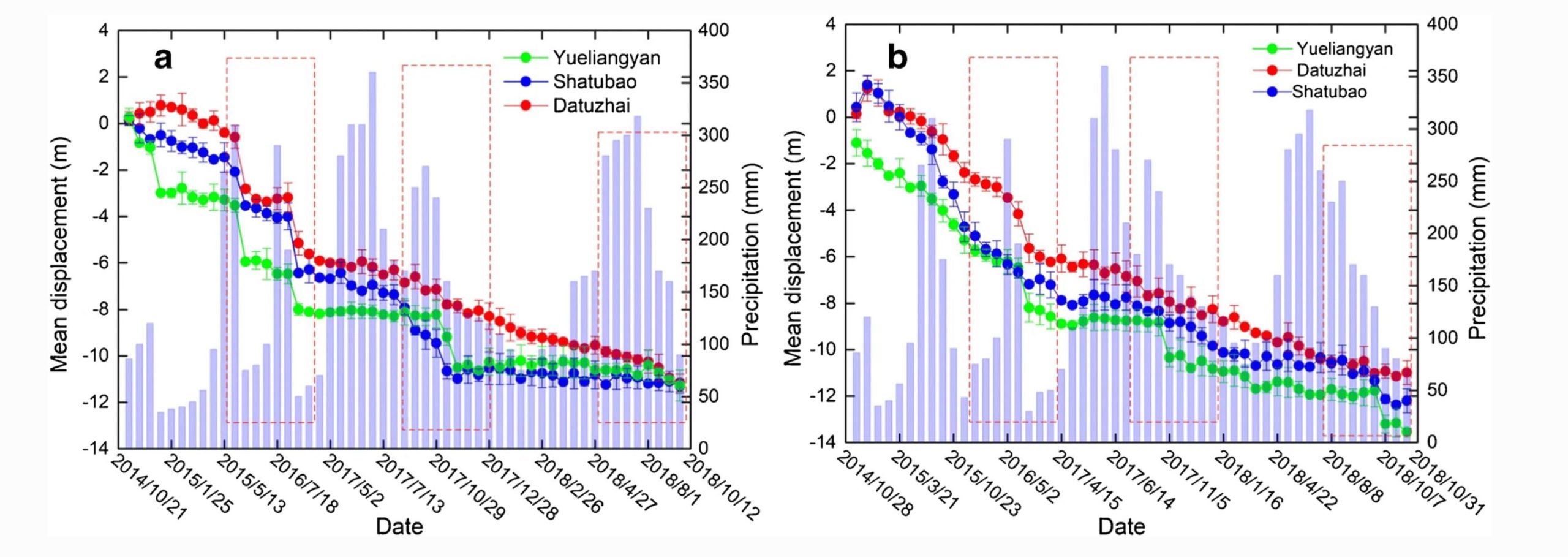
The displacement and precipitation of the slopes at Zongling, from Wang et al. (2020). The graph on the left shows Sentinel-1 ascending data, whilst the one on the right shows Sentinel-1 descending data.
.
I urge caution in interpreting this graph though as something very odd is going on with the time series. The intervals between the x-axis labels are highly non-linear – for example there are four tick marks for data in 2018 and only one for 2016. So on first inspection the data appears to be a linear time series, but is not. I don’t think that data should be presented like this, and I’m surprised it got through the refereeing process in this form, but the episodic movement of the landslides appears to be evident.
But there is another factor in play here too. Wang et al. (2020) describe extensive coal mining in the Zongling area, including extraction over the last 25 years of coal from galleries located directly below the slopes. The InSAR data suggests that there is extensive deformation occurring on the lower portions on the slopes, suggesting that a key factor in these landslides might be disturbance caused by the mining.
Reference
Wang, J., Wang, C., Xie, C. et al. 2020. Monitoring of large-scale landslides in Zongling, Guizhou, China, with improved distributed scatterer interferometric SAR time series methods. Landslides. https://doi.org/10.1007/s10346-020-01407-5.
 Dave Petley is the Vice-Chancellor of the University of Hull in the United Kingdom. His blog provides commentary and analysis of landslide events occurring worldwide, including the landslides themselves, latest research, and conferences and meetings.
Considering Scale, its correct exhibition in graphs is very important. I was participating in a Webinar last week and a representative of a global geospatial products firm described Green areas as not moving, and showed a time series graph that displayed the exact opposite. Color coding in the reference bar as well as representative scales, are very important in considering “accurate” our visual affection for reality.
Precipitation events — need to be qualified to a local weather station or source, or have similarly mapped and geocoded satellite data aligned with the event and or displacement assessment site. We commonly see precipitation events are precursors to slope and or surficial subsidence and heaves — on an annual or multiyear review similar cyclical and one or several days delays are common between rain events and the indications of slope activity.
Hi Dave,
I’m a geologist, and for several years beginning in 2010, I directed the geomechanical department at Freeport McMoRan’s open-pit copper mine located at Bagdad, Arizona. The ground-based InSAR (GBSAR) is nearly the same technology that orbiting satellites use. The GBSAR advantage, which is currently being exploited by open-pit mines around the world, is the 2-4 minute acquisition, processing, and presentation of data. Also, the ground-based InSAR has submillimeter accuracy, and a trained professional using other features within the software can now detect the onset of displacement and the onset of acceleration. From a safety and risk reduction point of view, the near-real-time presentation of data is a huge advantage as opposed to the typical 11-day satellite interval and even slower data processing techniques used by SatSAR data providers. I have a blog post titled “Using Slope Movement Trends to Maintain Production and Reduce Risk in Near Real-Time” that has time-series data from the Bagdad Mine. In this data, you can see how acceleration events could easily be missed during 11-day acquisition intervals. I personally predicted, almost a week in advance, nearly the exact time of a 5-million ton failure at the Bagdad open-pit mine in 2012. I have since made several other successful predictions and developed some rockfall techniques while monitoring the Mud Creek Landslide in California, see my blog that discusses the method. At Freeport, we use SatSAR day as a tool to give us a heads up on areas that begin to show displacement outside of the mine-pit where we employ our ground-based radars. Kind of an early warning system.
My personal website/blog is located at https://steveborron.wixsite.com/geohazards
Best Regards,
Steve Borron