
16 July 2019
Cobriza, Peru: another significant tailings dam failure
Posted by Dave Petley
Cobriza, Peru: another significant tailings dam failure
Another significant tailings dam failure occurred at Cobriza in Peru on 10th July 2019. Cobriza is a copper mine – interestingly, some reports indicate that “the concentrator was operated at a rate quite below its capacity due to lack of mine ore and lately (2016 and 2017) due to lack of capacity in the tailings dam“. The plant is also subject to a privatisation, originally planned for 2018 but now expected this year. The site is at -12.58, -74.37 if you want to take a look.
The failure is quite clear in Planet Labs images of the site, collected over the last few days. To get an understanding of the site, take a look at this Google Earth image of the mine and the tailings facilities. The view is taken looking towards the west:-
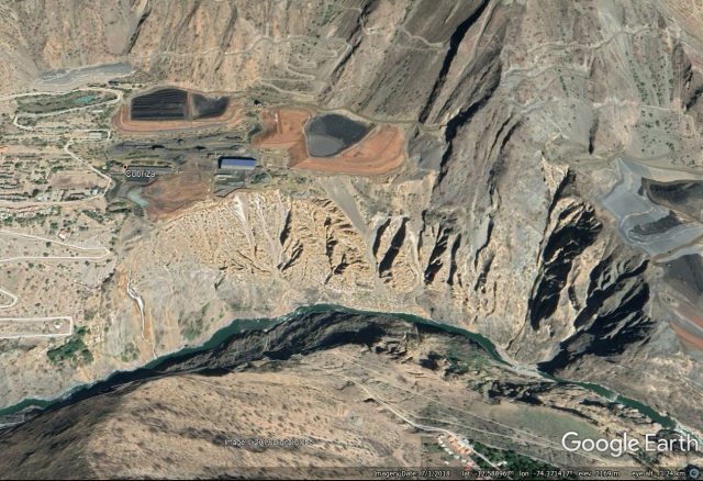
A Google Earth image showing the site of the Cobriza mine in Peru. Note the two tailings facilities.
.
The two tailings facilities are larger than they might first appear – the one on the right (which failed last week) is about 500 metres x 300 metres.
This is a Planet Labs image from 9th July 2019, before the failure, with north at the top of the image:-
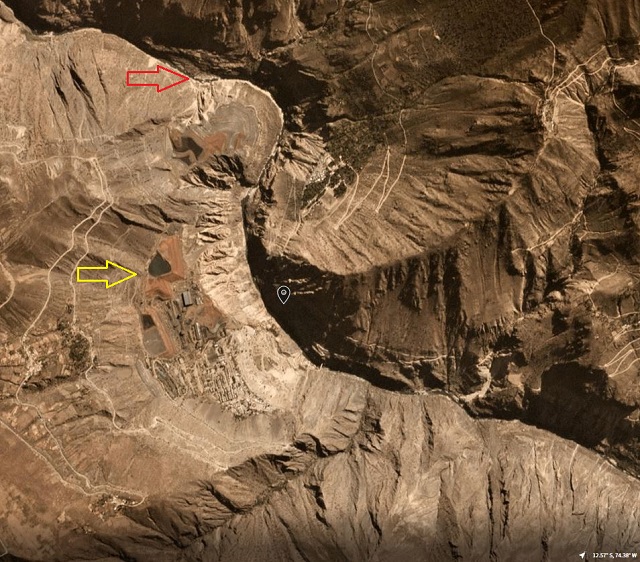
Planet Labs PlanetScope image, dated 9th July 2019, showing the Cobriza mine. Image copyright Planet Labs, used with permission.
.
I have highlighted two locations. The yellow arrow indicates the tailings facility that underwent failure last week. The red arrow indicates the bed of the river downstream of the site – note that the water was clear when the image was collected.
The image below, dated 12th July 2019, shows the mine after the failure:-
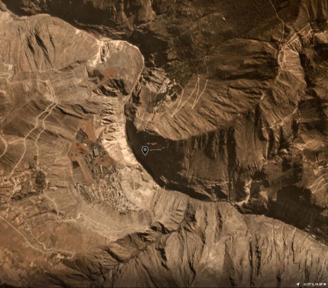
Planet Labs PlanetScope image, dated 12th July 2019, showing the Cobriza mine. Image copyright Planet Labs, used with permission.
.
The change in the geometry of the tailings facility is apparent, marking the site of the failure. The water downstream is obviously contaminated. Note that the water upstream of the mine (bottom right side of the image) is still clear (i.e. unpolluted).
I have provided further detail in the Planet Labs image below:-
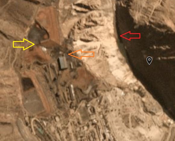
Planet Labs PlanetScope image, dated 9th July 2019, showing the Cobriza mine. Image copyright Planet Labs, used with permission.
.
In this image I have highlighted the breach of the tailings dam with the yellow arrow. The orange arrow indicates clear tailings contamination of the bench around the mine facilities. The red arrow marks the point at which the tailings are entering the channel – note the distinct change in the water colour.
The escape of the tailings has generated a serious pollution incident in the Rio Mantaro. There are fears that a stretch of the river extending for 375 km has been contaminated with cyanide. This video on Youtube reportedly shows the contamination in the Rio Mantaro:-
.
At risk of sounding like a scratched record, I once again emphasise that the failure rate of tailings dams is utterly unacceptable.
Reference and acknowledgement
Thanks to David Reid for spotting this one.
Planet Team (2019). Planet Application Program Interface: In Space for Life on Earth. San Francisco, CA. https://www.planet.com/
 Dave Petley is the Vice-Chancellor of the University of Hull in the United Kingdom. His blog provides commentary and analysis of landslide events occurring worldwide, including the landslides themselves, latest research, and conferences and meetings.
I’ve worked on the Tablachaca dam, 48 km Northwest of Cobriza (Heading 285º), in a monitoring project. Then the water of Mantaro river was affected by a spill of another copper tailings dam, upstream. It seems there’s not enough monitoring or a minumum of care about these happenings. Really sad.
Amid the usual lack of hard information just a few questions re this post:
1) If it is a just a copper mine it is hard to see that there would be cyanide used in the process.
2) In the wet season on Peru many streams have a high sediment load after rain, it doesn’t need a dam failure to get muddy water.
[I cannot comment on the former, but news reports in the last few days focus on tests for heavy metals. The latter is true, but the satellite images in the post clearly show that the turbidity in the water is coming from the mine. This is not in dispute. D.]
Just a note: there is a third tailing (just south from the red arrow on the second figure, -12.58, -74.37) build on the body of old landslide arround which accumulation the river makes sharp left turn (the landslide pushed river bit to the opposite valley side).