29 May 2019
The Baiyun–Liwan submarine slide: an ancient giant landslide in the South China Sea
Posted by Dave Petley
The Baiyun–Liwan submarine slide: an ancient giant landslide in the South China Sea
It is well-established that the largest landslides on Earth occur in the oceans. The most famous is the Storegga slide in the northern Norwegian Sea, which is generally thought to have a volume of about 3,000 cubic kilometres. Whilst being remote from people, submarine landslides are not are of just an academic interest. They have the potential to generate significant and damaging localised tsunamis and they pose a significant risk to the increasing amounts of underwater infrastructure, such as power interconnectors, fibre-optic cables and pipelines.
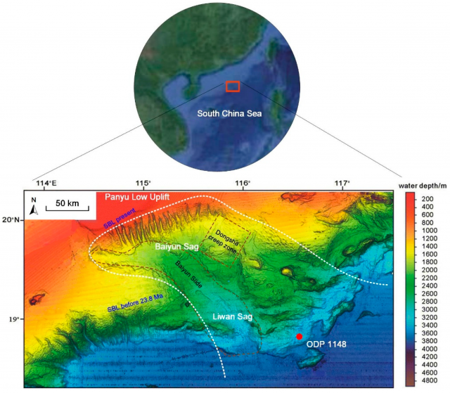
In a paper in the Journal of Marine Science and Engineering, Zhu et al. (2019) report the discovery of a new, very large submarine landslide in the South China Sea. This landslide, termed the Baiyun–Liwan submarine slide, is located in the Pearl River Mouth Basin. The landslide is one of the largest discovered to date, covering a surface area of 35-40,000 km² and extending over a distance of about 250 km. The image below, from the paper, shows the landslide scar in the continental shelf margin:-

The scar of the Baiyun–Liwan submarine slide, from Zhu et al. (2019)
.
The white dotted line is the landslide scar. Note the scale bar to get an idea of the amazing size of this landslide.
The site has been drilled by the Ocean Drilling Program, site ODP 1148. The core recovered from this site shows a characteristic slump material, interpreted by Zhu et al. (2019) as being a part of the deposit from the Baiyun–Liwan submarine slide. This puts the date of the landslide at 23.5 to 24.5 million years ago. Note however that parts of this landslide are thought to still be active – for example, the Dongsha Creep Zone shown in the image above, still shows signs of slow movement today. Whilst this is small compared with the overall scale of the landslide, it is still huge, covering an area estimated to be about 800 km².
The trigger for this landslide is, of course, unclear. Interestingly, Zhu et al. (2019) speculate that it could have been associated with well-constrained tectonic deformation in this area at about the same time, and at least one other giant submarine landslide is found in the region dating from the same period.
A giant landslide of this type has the potential to generate a significant tsunami, as was the case for the Storegga landslide. Whilst the likelihood of such an event recurring is likely to be very low, the density of population and infrastructure (including offshore facilities) in the Pearl River Delta region means that the consequences could be high. Thus, such features deserve further investigation.
Reference
Zhu, C., Cheng, S., Li, Q. et al. 2019. Giant Submarine Landslide in the South China Sea: Evidence, Causes, and Implications. Journal of Marine Science and Engineering, 7 (5), 152. https://doi.org/10.3390/jmse7050152.


 Dave Petley is the Vice-Chancellor of the University of Hull in the United Kingdom. His blog provides commentary and analysis of landslide events occurring worldwide, including the landslides themselves, latest research, and conferences and meetings.
Perhaps coincidence, but striking resemblance to the Porcupine Bank & Sea Bight off Eire coast ??
Interesting!
Thank you Prof David Petley for bringing this to our attention. These phenomena are staggering and somewhat challenging to explain considering the seismic geomorphology and geomechanical state of knowledge. They should certainly be a focus of research and investigation for the reasons you highlight.
Thanks for bringing us this report, I’m wondering if this interpretation is too bold, as the Slide boundary (the white dotted line) seems arbitrary to me. Do we see the slide boundary on the bathymetry map? I think we don’t… The ODP data could reveal adjacent slide info rather than the very regional Baiyun-Liwan Slide, just a thought 🙂