
1 March 2019
US101 at Brookings: an interesting, disruptive landslide
Posted by Dave Petley
US101 at Brookings: an interesting, disruptive landslide
On Tuesday, significant movement occurred on a large landslide in Oregon, closing the important US101 highway near to the coastal town of Brookings. This landslide (location 42.219, -124.374), which seems to have been triggered by heavy rainfall, is captured very nicely in a drone image Tweeted by Tidewater Contractors:-
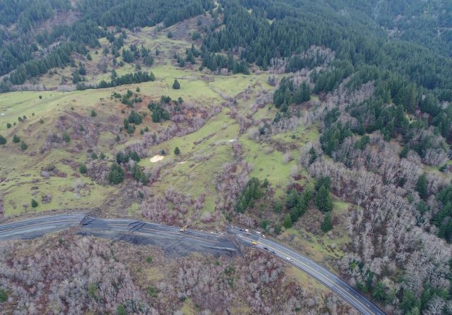
The major landslide on US101 at Brookings. Image via Tidewater Contractors on Twitter
.
Tidewater Contractors have also tweeted this rather splendid image of the main part of the landslide:-
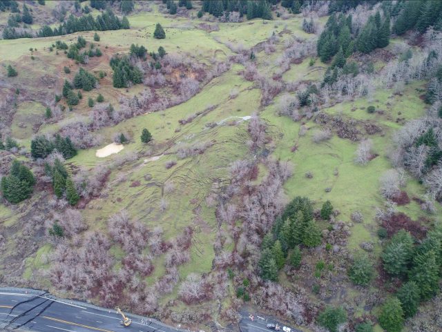
The main body of the US101 landslide near to Brookings in Oregon. Image tweeted by Tidewater Contractors.
.
This appears to be a large, moderately deep earthflow. Note the very clear scarps at the crown of the landslide and the beautiful array of tension cracks in the area in which the landslide mass steepened. Note also the very clear lateral scarps on the lower slopes towards the highway. The disruption to the road is very significant; Tidewater Contractors have tweeted a drone video showing the road damage, whilst the image below shows the impacts in more detail:-
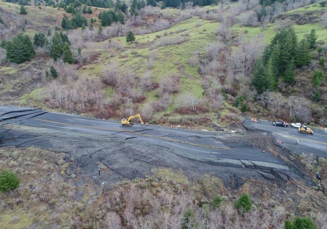
Road damage on Highway 101 near to Brookings caused by the large earthflow on Tuesday. Image tweeted by Tidewater Contractors.
.
There is an interesting article on Willamette Week that examines these types of landslide in Oregon in the context of climate change, drawing upon recent studies and expert knowledge. They note that these areas are being affected by both increases in groundwater level and by increased erosion of the coastal bluffs due to increased wave energy. This is the Google Earth imagery of the US101 landslide, with the image dated 3rd July 2016:-
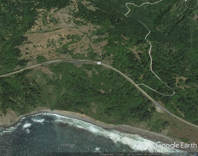
Google Earth imagery from July 2016 showing the site of the US101 landslide near to Brookings in Oregon.
.
The landslide is clearly identifiable in the Google Earth imagery, and there is evidence that movement has disrupted the road. The image demonstrates that the toe of the landslide is being eroded by wave action, leaving the slope more susceptible to the effects of increased groundwater levels.
The road is set to be closed for at least a month.
 Dave Petley is the Vice-Chancellor of the University of Hull in the United Kingdom. His blog provides commentary and analysis of landslide events occurring worldwide, including the landslides themselves, latest research, and conferences and meetings.
From Google Maps / Street View, it would seem that that secion of road has moved previously and been patched up before.
https://www.google.ie/maps/@42.2185431,-124.3716146,3a,75y,354.73h,67.1t/data=!3m6!1e1!3m4!1sVDejA4X2JQ-W00K8q0LZNg!2e0!7i13312!8i6656
If I recall correctly, this is made worse by a pulverized serpentinite substrate. This segment goes out frequently, but there’s really no way to avoid it.
Thank you for Earthflow.
Build a bridge….
Add all the man hours, equipment hours, tons of rock and massive tons of asphalt… The bridge would already be 55% built by now!!!!!
Also worthy of note from historical Google Earth Imagery are: 1) previous repairs of the highway crossing of the landslide; 2) the substantial surcharge that the repairs added to a sensitive part of the landslide; and 3) the stockwater dam added to the stream after 1990 near the head of the post-1990 recurrent landslide affecting US101.
This is where my brother and his wife lived for many years but recently moved. This is amazing!
It baffles me how anyone could think that there is no climate change.
There is a lineament (topographic and vegetation) in the first image cutting from upper center to lower right. Is this significant, or am I seeing things because I’m a primate? Haha!