
24 July 2018
Fagraskogarfjall landslide – a high resolution satellite image via Planet Labs
Posted by Dave Petley
Fagraskogarfjall landslide – a high resolution satellite image via Planet Labs
Planet Labs have succeeded in collecting a high resolution satellite image of the Fagraskogarfjall landslide, the very large mass movement that occurred in Iceland on 7th July 2018. As a reminder, this is one of the largest known landslides in Iceland in recent history, triggered by the prolonged period of heavy rainfall from which the country has been suffering. The image was collected on 19th July 2018 using the SkySat satellite system, providing a very high resolution (and actually rather spectacular) image:-
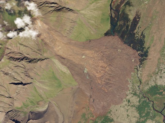
Planet Labs SkySat image of the Fagraskogarfjall landslide in Iceland. SkySat Image dated 19th July 2018, used with permission.
.
The high mobility of the Fagraskogarfjall landslide is evident from the image, with the deposit traveling a substantial distance across the flat terrain at the toe of the slope. I wonder in this case whether the likely saturated conditions in the valley floor may have increased mobility. The image also suggests that there may have been a second, smaller event with the debris falling onto the remains of the first failure. This would seem to be the most likely explanation for the lighter coloured debris that sits on the main landslide deposit:-
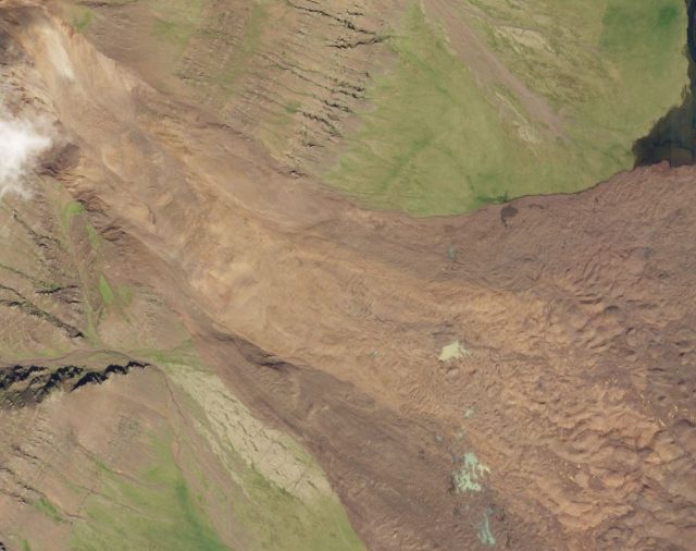
Detail of the Planet Labs SkySat image of the Fagraskogarfjall landslide. SkySat Image dated 19th July 2018, used with permission.
.
This landslide also appears to have developed a very distinctive hummocky topography:-
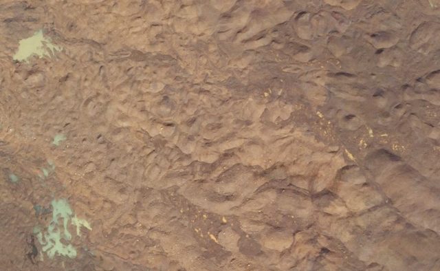
Detail of the Planet Labs SkySat image of the Fagraskogarfjall landslide, showing the hummocky terrain. SkySat Image dated 19th July 2018, used with permission.
.
This sort of hummocky terrain is common in landslides in volcanic terrain. These hummocks are formed by extensional faulting in the early stage of landslide movement. As the landslide ,movement develops, large blocks of mobile material develop and spread. In general, it has been noted that the largest hummocks lie at the rear of the landslide deposit, with smaller features at the front. There is some evidence of that in this case. If you are interested in this process, it has been modelled by Paguican et al. (2014). The paper is online as a PDF.
References
Paguican, E.M.R., van Wyk de Vries, B. & Lagmay, A.M.F. 2014 Hummocks: how they form and how they evolve in rockslide-debris avalanches. Landslides (2014) 11: 67-80. https://doi.org/10.1007/s10346-012-0368-y
Planet Team (2018). Planet Application Program Interface: In Space for Life on Earth. San Francisco, CA. https://api.planet.com
 Dave Petley is the Vice-Chancellor of the University of Hull in the United Kingdom. His blog provides commentary and analysis of landslide events occurring worldwide, including the landslides themselves, latest research, and conferences and meetings.
Interesting. Thank you so much for the article reference
Looking at the site in Google Earth, it’s apparent that the slope was showing significant signs of deformation and distress in 2012, but that not much had changed in 2015. Interesting to then see it fail so catastrophically.
wow, this is truley amazing to see such an unusal topography. Love the work guys…and girls! cant be sexist.
Im going to show this article to my family around the dinner table!!!!.They will love this to