
5 August 2016
The Jishi Gorge landslide, China: an earthquake-induced landslide that changed civilisation?
Posted by Dave Petley
The Jishi Gorge landslide, China: an earthquake-induced landslide that changed civilisation?
The Jishi Gorge Landslide: in a paper in the journal Science today, Wu et al. (2016) reconstruct an ancient flood from a landslide dam breach on the Yellow River in China. This flood was reportedly an important cultural event in China as early historiographies of China, such as the Shujing (Book of Documents) and Shiji (Records of the Grand Historian) report a devastating flood on the Yellow River over 3,500 years ago. Emperor Yu the Great reportedly tamed the flood (probably actually managing the aftermath of the river changes caused by the flood), whereupon he established the first Chinese dynasty, the Xia, thus changing civilisation forever. However, many scholars see the Xia dynasty as being mythical, not helped by the fact that evidence for the Great Flood has been lacking.
In their paper, Wu et al. (2016) have identified a potential landslide dam source of the Great Flood, and have mapped and dated the associated deposits. They propose that the flood was generated by the collapse of the Jishi Gorge landslide on the Yellow River, and they have identified the potential location of the landslide. This is a Google Earth image of the site – the landslide scar is on the right (south) side in the area labelled Shaolunzi Bay. The scar is very clear, extending to the ridge:
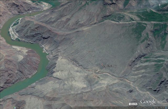
The Jishi Gorge landslide via Google Earth
.
The landslide scar is about 1.8 km from crown to the river, and about 1.5 km in width. The elevation of the crown is at about 2480 m, whilst the toe of the landslide is at about 1840 m, giving a height of the crown of about 640 m. This is a very large landslide – the authors estimate a dam volume of 40 to 80 million cubic metres. It sits on the outside of a river bend, suggesting that erosion by the flow may have been a factor is creating the opportunity for sliding. The form of the landslide is translational (i.e. planar sliding) – the outcrops near to the scar suggest that this might have been on an existing plane of weakness.
On the other side of the river is a very clear landslide deposit, as identified by Wu et. al (2016):
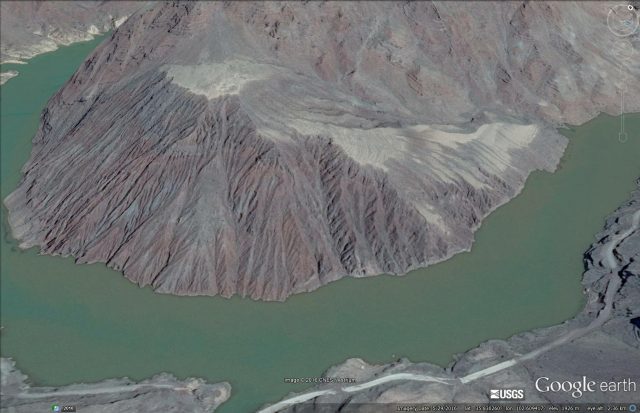
The Jishi Gorge landslide deposit via Google Earth
.
Not unusually the breach has occurred on the landslide scar side of the river. Wu et al. (2016) have mapped and dated the lake bed deposits from the landslide dam – this area on the far side of the river just upstream of the dam is identified as one:
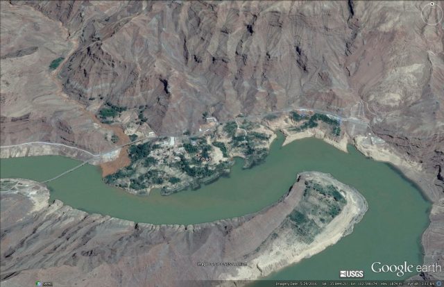
Jishi Gorge landslide dam deposits via Google Earth
.
Whilst downstream sediments deposited by the outburst floods have also been identified:
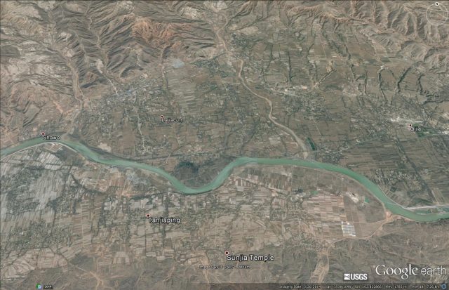
Outwash sediments from the Jishi Gorge landslide via Google Earth
.
Wu et al. (2016) suggest that the volume of water released by the breach event would have been between about 11 and 16 cubic kilometres, generating a flood with a peak discharge of about 400,000 cubic metres per second, 500 times the average discharge. As such it would have been one of the largest known river floods in the Holocene.
I suspect that the linkage between this event and the evolution of the Xia dynasty is going to be highly controversial. The presence of the remains of a very large landslide, and associated lake bed and breach flood sediments, seem reasonable. If Wu et al. (2016) are right then this is a landslide that truly changed the world.
Reference
Wu, Q et al. (2016) Outburst flood at 1920 BCE supports historicity of China’s Great Flood and the Xia dynasty. Science, 353 (6299), 579-82.
 Dave Petley is the Vice-Chancellor of the University of Hull in the United Kingdom. His blog provides commentary and analysis of landslide events occurring worldwide, including the landslides themselves, latest research, and conferences and meetings.
FYI – a rockfall:
House-sized boulder blocks highway in Utah’s Zion National Park – August 11, 2016 – http://www.foxnews.com/us/2016/08/11/house-sized-boulder-blocks-highway-in-utahs-zion-national-park.html