
28 May 2014
Grand Mesa: an unusually large and mobile mudslide
Posted by Dave Petley
The Grand Mesa mudslide
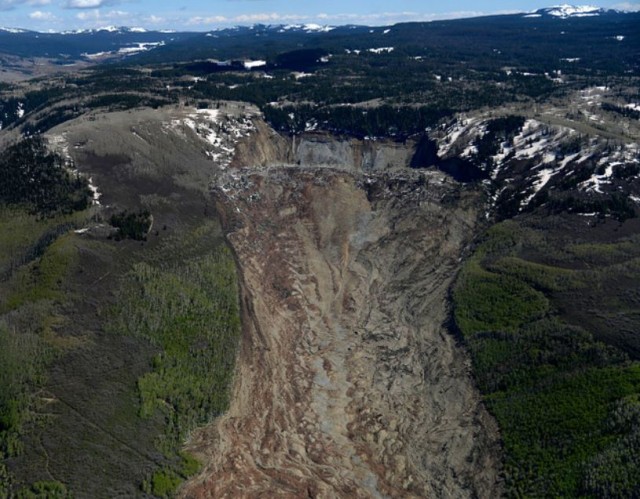
Mesa County in Colorado, USA suffered an unusually large and mobile mudslide this weekend, which appears to have resulted in the deaths of three men. The landslide is surprising in many ways, not least the scale and the apparent mobility of the mass. The Denver Post has a great set of images of the landslide, including this one:
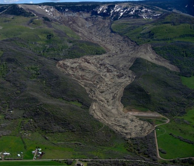
Aaron Ontiveroz/The Denver Post
..
The scale of the landslide can best be appreciated from this video, taken by the Mesa County Sheriff’s Office:
..
The landslide is reportedly half a mile (900 m) wide and between 2 and 3 miles (3.5 – 5.1 km) long. The victims appear to have been investigating reports of a blocked irrigation canal, presumably from an earlier movement event. The mobility of the landslide does seem to be unusual – note how the slide has overtopped a ridge on the right side (as seen in the photograph above). The elevation reached by the mass on the upslope side of this ridge is quite surprising.
The landslide mass has some fascinating flow structures that with interpretation will tell us a great deal about the movement of the landslide. For example, this Denver Post image of the landslide shows the structures in the toe area. To me, this suggests that the landslide should really be classified as a mudflow rather than a mudslide, or in fact technically as a complex landslide consisting of a rotational landslide that transitioned into a mudflow:
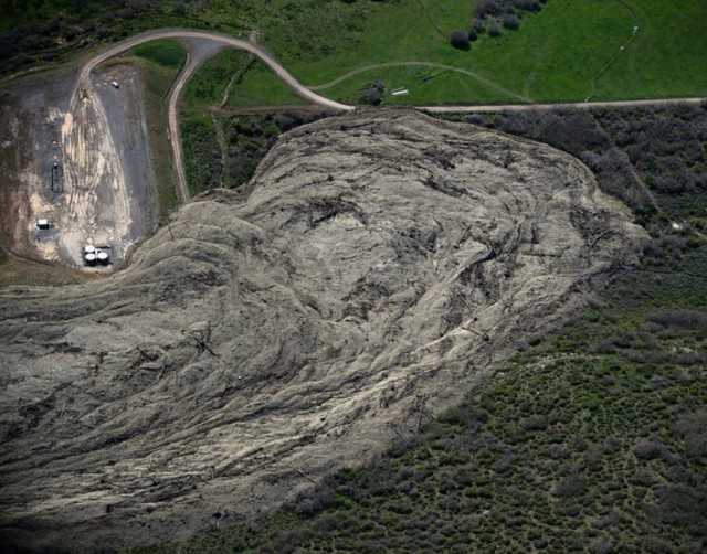
Aaron Ontiveroz/The Denver Post
..
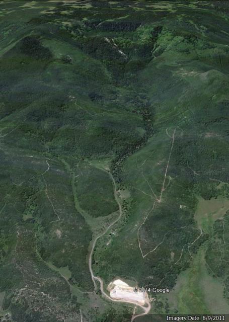
This is the Google Earth perspective view of the site before the collapse (this image is dated 2011):
 ..
..
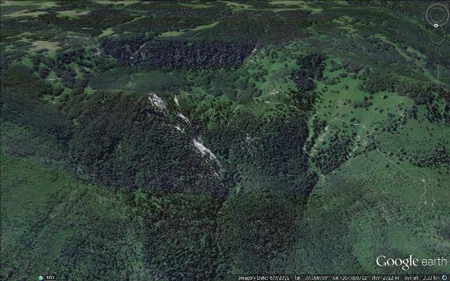
The upper reaches of the landslide clearly consist of an old rotational landslide block – this is clearer on a zoomed in image:
 ..
..
Compare this with the Denver Post photograph of the same area after the recent failure:
Aaron Ontiveroz/The Denver Post
..
It is quite hard to interpret this, and my initial view (that there was a new rotated block) is not the case I think. My reading is that the forested rear scarp of the old landslide remains intact. The rotated block appears to have undergone a second rotational failure, possibly on the same failure plane? A part of this rotated block has remained intact, but most has disintegrated to form the mudflow. Rotated blocks do degrade and form mudflows – this is the case in many such slides. But this catastrophic disintegration to form a high mobility mudslide looks really interesting, so will merit a detailed investigation. Perhaps the whole mass underwent a rotational failure, which caused the lower part of the block to disintegrate and form the flow.
Given that the reported rainfall prior to the failure was nothing special, something quite unusual seems to have happened here.
Unfortunately, the site looks to be quite dangerous, especially in the next heavy rainfall. I wonder also what the platform at the toe of the slide is for (see the second image above)? There are several similar structures in the area around the landslide.
 Dave Petley is the Vice-Chancellor of the University of Hull in the United Kingdom. His blog provides commentary and analysis of landslide events occurring worldwide, including the landslides themselves, latest research, and conferences and meetings.
The platform at the toe of the slide is most likely a natural gas wellhead. There are platforms like this all over the region. I wonder if they have any contingency plans for one (or more) of these to be damaged/buried in such an event?
There was a very high rainfall event in early September 2013 and a higher than average snowfall over the past winter. It seems likely these are contributing factors.
With the unremarkable rainfall, I wonder where all the water came from? No heavu snow pack to be melted suddenly. No obvious pond at the rear of the old slide mass in the historical imagery, but it could’ve been flat enough back there to retard overland runoff and help saturate the old mass by increasing its “residence time” on the mass. Clearly a very fluid mass given the way the mid slope ridge was overrun and the pahoehoe lava-like flow structures at the toe.
Waiting for it to be blamed on leakage of fracking fluids…………….
Close-in Sheriffs’ drone video taken the next morning (see your updated Denver Post link) shows what appears to be a dry debris field. I’d expect to see numerous ponds, and water actively draining out of such an apparently fluid mass. Wondering if this was a catastrophic failure, and entrapped air may have been a factor, similar to the Blackhawk Slide in Southern California?
This article confirms that it is a natural gas wellhead operated by Occidental Petroleum: http://dirt-lab-dispatch.blogspot.com/feeds/posts/default
This article confirms that it is a natural gas wellhead operated by Occidental Petroleum: https://www.hcn.org/articles/colorado-mudslide-reveals-risks-in-energy-planning-1/view [Corrected link]
The geology of the Grand Mesa regional area is sensitive to slope failure processes and consists of a volcanic (basalt) cap primarily overlying Cretaceous bentonitic shale bedrock. Most of the the Surficial deposits below the Volcanic cap on the slopes surrounding the mesa consists of a complex series of paleo landslides, mudflows and mudslides in various stages of instability. Contributing factors other than typical precipitation and snow melt to the instability are numerous irrigation ditches and irrigation lakes and natural lakes within the slope failure complex and on top of the fractured thick basaltic mesa. Slope failure issues are more prevalent and appear to be more active on the north facing slopes of the mesa as the north facing slopes tend to retain more moisture over a longer period of time that the south facing slope.
Colorado, in general, has had a higher than normal snow pack this year and this may have had a reasonably significant impact during this years spring melt, however, having said that it is also uncommon in my 30 plus years experience in the State to have such a rapidly moving event in a coherent mass to occur over such a large area. It would not be surprising to seeing similar events to occur here as well as other areas of the State due to similar factors. We will see as we are now in the major snow melt period.
Flew right by the slide in Sept 2016 in a Cessna 210 and took a photo. I see that I can’t post it within this comment, so if anyone is interested, send me an e-mail and I’ll forward it to you.
William:
I write now with repect to the message you posted to the Landslide Blog you posted to the AGU100 Blogosphere October 2016.
I’m faculty in Geography at Virginia Tech (as a side note – previously, when I was in the service, I was a Colorado resident . . . ). I would be much interested in the photo you mention of the 2016 Grand Mesa mudslide, for use in my classes. And, I would be especially interested to have your permission to use it as an illustration for a forthcoming text book.
My email– [email protected]
With best regards,
Jim Campbell
—————————
James Campbell,
Department of Geography, Virginia Tech, Blacksburg, VA, 24061.
Just FYI, though this is more than a bit late, the Colorado Geological Survey published a comprehensive report on the landslide:
White, Jonathan L., Matthew L. Morgan, and Karen A. Berry. “Bulletin 55 – The West Salt Creek Landslide: A Catastrophic Rockslide and Rock/Debris Avalanche in Mesa County.” Bulletin. Golden, CO: Colorado Geological Survey, 2015. Bulletin 55. https://coloradogeologicalsurvey.org/publications/west-salt-creek-landslide-catastrophic-rockslide-avalanche-mesa-book.
Hi, William
I’m a PhD student from Southwest Jiaotong university. I major in rock avalanche dynamics and am extremely interested in this landslide. Especially its flow path and fluidized platflom. And I mentioned you took some photos about this landslide. I am wondering whether you could send me? I am strongly eager to know more about it. If I would use this for presentation or else, I will tell you in advance.
My e-mail:[email protected]
Warm regrads,
Hiko