
16 September 2010
Zhouqu landslide – NASA satellite image
Posted by Dave Petley
NASA have somehow managed to find a gap in the clouds to collect a satellite image of the Zhouqu landslide site. Readers at the time of the landslide last month will remember that I was wondering about the source of the slides. Although this image does not give a full answer, it gets us a part of the way there:
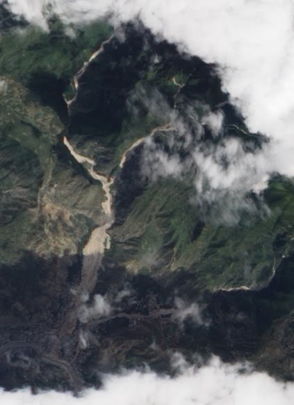
A zoom into the affected area yields this:
The slides (note the smaller one to the right of the main event) clearly originated as a series of smaller slips on the walls and headwaters of the upstream catchments. These appear to have coalesced to form the main events. This is consistent with processes observed elsewhere during periods of exceptional rainfall.
Meanwhile, I am now in Christchurch in New Zealand, site of the earthquake of 12 days ago. Every 30 minutes or so my chair shakes as an aftershock rattles the area, which is a very surreal experience.
 Dave Petley is the Vice-Chancellor of the University of Hull in the United Kingdom. His blog provides commentary and analysis of landslide events occurring worldwide, including the landslides themselves, latest research, and conferences and meetings.
Dave I'm sure you never thought you would physically experience a major geo-event after studying them from afar all these years. It's kind of a funny turn.Brigitte
As this Posting looks back to a previous event I just want to hint all readers to the Pamir Times (http://www.pamirtimes.net), where you can see the water in the Attabad Landslide lake is dropping now. From the pictures they uploaded on Saturday, 18th I would guess the lake lavel has dropped for about 5 meters now.Also very interesting a post on Sept 17th there: Another possible landslide location just some km upstream from Attabad lake…Best regardsulsc