29 April 2010
Latest update on the Attabad landslide in Hunza
Posted by Dave Petley
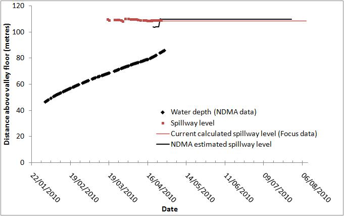
The lake level at the Attabad landslide continues to rise at about 55 cm per day, reflecting the increased level of inflow from snowmelt. NDMA and Focus now conduct joint surveys of the freeboard and have agreed a broadly common figure – currently about 23 m. At current rates this continues to indicate an overtopping date of early June (full details on the monitoring site):
Seepage remains a concern, although at the moment the rate of increase remains linear with time over recent days:
Meanwhile, the length of the lake is now extending quite rapidly as the valley gradient at the head of the lake is low, as this Pamir Times image shows:
I remain deeply concerned about the potential for failure through seepage or another landslide, and of what will happen at the point of overtopping.


 Dave Petley is the Vice-Chancellor of the University of Hull in the United Kingdom. His blog provides commentary and analysis of landslide events occurring worldwide, including the landslides themselves, latest research, and conferences and meetings.
Yesterday sliding happened near Pasu, from the glacier I understand. Do you think this will lessen flow into the lake significantly? Looking at satellite images it seems that there are many other sources of inflow south of this new slide. Also, does this Pasu slide explain some of the strange sounds heard a week ago or so in Shishkut?
Mostly fresh water lakes are formed in same way naturally. If it is desastrous on one hand, it is very usefull on the other. Timely sensing of danger, proper planning and quick security measures could save lots of problems. This lake can now be used for the power generation to augment power shortages of Pakistan. This can also be used as water reservoir to boost up water resources specially during dry weather when India is violating Indus Treaty and holding water thus trying to barren Pakistan.Lake area can be developed for tourism and also it will attract migratory birds.