
5 August 2009
30 years ago – the Abbotsford landslide, New Zealand
Posted by Dave Petley
As well as being something of a landmark birthday for my wife Kirstie, Saturday will also be the 30th anniversary of one of the best known and most interesting landslides in New Zealand – the Abbotsford landslide of 8th August 1978. This was a large (5 million cubic metre) slide that caused the loss of 69 houses, with an overall cost of about NZ $10 million. Fortunately, no lives were lost. The landslide was recently described in a paper by Graham Hancox (Hancox 2007) of GNS Science, from which I have gained most of the information here.
The landslide occurred in a suburb of the South Island of Dunedin. The remarkable picture below, from the Hancox paper, shows the state of the site three days before failure:
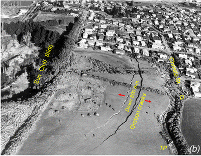
On the left side of the image (the east) lies a quarry from which about 300,000 cubic metres of sand had been removed. Running across the centre right of the image is a large array of cracks that were opening up as the landslide moved. These cracks clearly extend into the suburb, although they become less easy to discern in this area. In fact cracking was first noted in some of the houses in 1972 or even before. Through time the cracks grew until in 1978 they defined the rear scarp of the landslide as seen above. The cracks caused several water main breakages in late 1978 and early 1979.
The slide was extensively monitored in the period before final failure. The data suggests that the rate of movement was steadily increasing through time, with rates as high as 10-15 cm/day being noted in the week before failure!
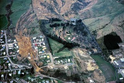
Final failure began at about 9 pm on 8th August. It lasted about 30 mins, during which time a large block moved forward by about 50 m, leaving a graben structure behind that was about 16 m deep. This is very clear in the image below. The slide was a deep-seated translational block slide that covered an area of about 18 hectares. It was about 800 m, 400 m long and up to 40 m deep. The average movement was about × 400 m, up to 40 m thick). According to Hancox (2007) it slid down a 7°-dip slope at an average speed of about 1.7 m/min. The rate of movement was sufficiently slow that no-one was killed, although many people needed to be rescued and, of course, lost their homes.
 (source: Teara)
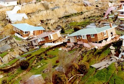 (Source: http://www.kvc.school.nz/Kaikoraistream/Intro_Folder/Geology.htm)
So why did the slope fail? Well, the first key factor is that the site was susceptible to failure under natural conditions. The materials were dipping in the same direction as the slope and were weak and susceptible to sliding. There were ancient landslide deposits on the site that point to previous instabilities, well before humans could have played a major role. Second, the removal of the sand from the quarry removed support from the slope, making it far more likely to fail. In fact, Hancox suggests that the slope only needed groundwater to increase by 0.5 m for movement to start.
The slide was probably triggered by increased water levels in the slope. This is likely to have come from two sources. First, the few years before the landslide were wetter than had been the previous 20 years or so. Second, Hancox (2007) suggests that there was a leaking water main that may have been allowing 5 million litres to enter the slope each year.
New Zealand is of course a landslide prone environment, but there can be little doubt that many lessons have been learnt from this failure. By modern standards it seems amazing that the houses were still inhabited when cracks as large as those shown in the first photograph were developing, and movement rates of 10 cm per day were being recorded. The authorities in New Zealand are clearly using the anniversary of the landslide to remind people of the need to remain vigilant.
Reference
Hancox, G.T. 2008. The 1979 Abbotsford Landslide, Dunedin, New Zealand: a retrospective look at its nature and causes. Landslides 5: 177-188. Journal page.
 Dave Petley is the Vice-Chancellor of the University of Hull in the United Kingdom. His blog provides commentary and analysis of landslide events occurring worldwide, including the landslides themselves, latest research, and conferences and meetings.
Hi – Thanks for an interesting analysis of the Abbotsford landslide. I've had to do a quick Geology 101 course over the past few days as we're making an offer on a house with 2 acres in Glenross, Dunedin, and there's a slump on the land. Being cautious types, we've paid a geologist to have a look at it (our offer is conditional) and make an assessment. His results come through to us tomorrow. But in the meanwhile, I'm brushing up on some details about slumps and landslides etc., and came across your blog posting about the famous Abbotsford case, which is just down the road from us (we live in Bradford, Kaikorai Valley, Dunedin at present).So thanks again. If you're interested, I'll let you know what the geologist "digs up" 🙂
I lived close by at the time, Sunnyvale, and one of the home-owners on the hill had an A-frame house. They were all asleep at the time and the father woke up when the power lines ‘pinged’ (his words) as his house started to give. He said he only just had time to wake all his family and get them out.