
17 May 2009
Landslides and the UN's Global Assessment Report on Disaster Risk Reduction
Posted by Dave Petley
 The UN ISDR is today launching with a great fanfare the first Global Assessment Report on Disaster Risk Reduction. This report “provides hard-hitting evidence to demonstrate how, where and why disaster risk is increasing globally and presents key findings from a global analysis of disaster risk patterns and trends, including where high mortality and economic loss is concentrated. .” The report is online now and can be downloaded here.
I haven’t yet had time to read the whole of the 200 page document – I will do so in due course – but have taken some time this morning to look at the landslide hazard / risk section in Chapter 2n. This was generated by the Norwegian Geotechnical Institute and has been peer reviewed by some eminent people. So how does it look?
I think a good starting point is to say that it has to be recognised that this is a very difficult thing to do. There are all sorts of problems in the collation and analysis of this type of data. However, I also have to say that I have some reservations about the outcomes, which don’t to me seem to correspond to what we actually observe.
The landslides section starts with a premise that I find bizarre. The opening sentence is as follows: “Observed mortality in landslides triggered by high precipitation is approximately six times higher than in landslides triggered by earthquakes.” Huh? No source or justification is provided for this statement. I just cannot see how it can be justified. In recent years we have large numbers of fatalities from landslides in the Kashmir earthquake and the Wenchuan earthquake, bit of which swamp the fatality signal from rainfall events. Perhaps this study was done before the impact of these events could be included, but there is plenty of documentation of mass fatalities from earthquake-induced landslides even before this event. Perhaps the problem here is that earthquake-induced landslides are included in the earthquake hazard section, but we should be under no illusions that the impact of this is ponce again to greatly under-estimate the risk associated with landslides. This is very frustrating!
The upshot is that the risk model considers only precipitation-induced landslides. We need to keep this is mind when evaluating the study. The headline result of the analysis seems to be (this is a direct quote) “The predicted mortality risk, even in very large countries such as India or China, is less than 100 deaths per year”. Being blunt, if this is the mortality risk analysis then the model is frankly wrong as the measured losses are much higher than this. Taking 2008 as an example, a year in which precipitation-induced landslide occurrence was not exceptional, I recorded 778 rainfall-induced landslide fatalities in China, 700 in Haiti and 252 in India. This is typical and is supported by official figures. Of course, every few years these countries suffer a very large landslide disaster (e.g. the Leyte landslide in the Philippines), which increases the average annual numbers. Therefore, the study has fundamentally under-estimated the risks of rainfall-induced landslide mortality still further.
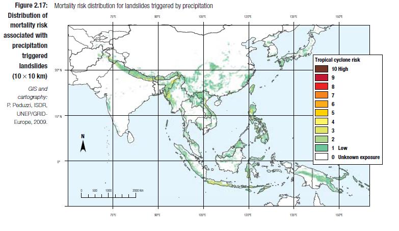
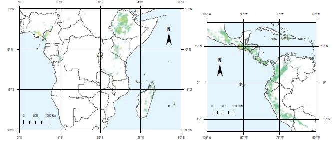
So let’s take a look at the maps. They have produced landslide risk maps on a 10 x 10 km grid. Three maps have been generated, which I reproduce below. The maps are for Asia, Central America (plus the NW of S. America) and Central Africa, presumably because these are the three areas with the highest level of landslide risk. Click on the maps for a better view in a new window. Note that the label on the legend of “tropical cyclone risk” is presumably just an error, albeit a rather serious one.
 This is my map of fatal landslides for 2006, 7 and 8. Each black dot represents a single fatal landslide:
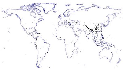 This map is close to being a direct realisation of the mortality risk analysis, although care must be taken given the short time period that my map covers and to remember that population density may be an important factor. The first thing to note is that the C. American and Asian areas are well-chosen given the high incidence of fatal landslides that I record. I am far less sure of the African area – I really don’t record much for that part of the world, although I recognise that this might be because I just don’t capture events in this part of the world, perhaps. In Asia the distribution seems to be vaguely right in that it picks up the swathe of events through the Himalayan arc and the high risk in Java, etc. However, it does appear to fail to pick up the landslide risk associated with Central China at all well. This may reflect the high population density here (i.e. although there are lots of fatal landslides, the risk to individuals is low), but I doubt that this is the whole story. My feeling is that the analysis is failing to represent landslides in this area well. A similar problem occurs in SW India, which is a notable hotspot. In Central / S. America the analysis seems to do rather better.
Overall I am left feeling that the representation of landslide risk is really unsatisfactory. It must be possible to do this better. I hope that the analysis of the other hazards is rather better – I am sure that it must be.
Comments welcome.
 Dave Petley is the Vice-Chancellor of the University of Hull in the United Kingdom. His blog provides commentary and analysis of landslide events occurring worldwide, including the landslides themselves, latest research, and conferences and meetings.
What about Europe?! Does the fact of not being included in this report means there is no landslide risk for us? The answer is clear for me: The UN’s report underestimated Europe and the so-called developed contries, so it cannot be considered “global”.Best regards from Portugal.