
25 January 2009
Two interesting recent landslides
Posted by Dave Petley
Two interesting landslides to report in the last few days.
1. Landslide in Iztapalapa, Mexico City
On Thursday morning a 50 cubic metre landslide in the Itzapalapa, a poor suburb of Mexico City slid onto a house at the toe of the slope, killing two people. Chinagate has published a rather dramatic picture of the site:
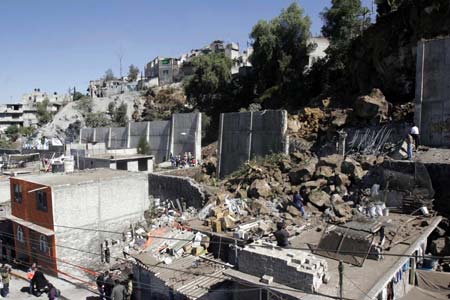 The interesting thing about this image is the very large (apparently 5 m high) retaining wall that had been built between the slope and the houses. Clearly the wall has failed under the weight of the landslide (not surprising given the size of those boulders actually), but I wonder who built the wall (surely not the people living in these houses – it is far too big)?
2. Landslide-induced wave on Lake Roosevelt, Washington State, USA
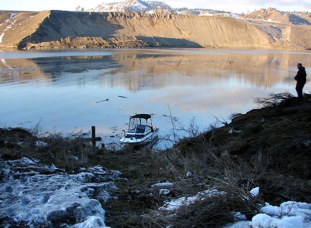
The second is a report from the Spokane arm of Lake Roosevelt near to Spokane in Washington State. The website Spokesman Review is carrying a report that says:
“Property owners in the Spokane arm of Lake Roosevelt were swamped by a huge wave caused by a landslide last Friday. The 17-acre landslide on Jan. 16 near Mill Canyon – northeast of Davenport and downstream from Little Falls Dam – slid into the water, unleashing a wave that reached 30 feet above the full-pool mark across the lake into Breezy Bay, according to Adam Kelsey, chief ranger for the Lake Roosevelt National Recreation Area. Private docks and vessels were destroyed or damaged for at least 1.5 miles downstream from the site.”
They also have an image of the site:
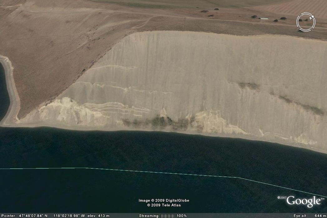
It is reasonable to assume that the displaced mass on the far side of the lake is the landslide as the Google Earth image does not show a slide at this site:
 It is interesting to note that the section of slope that has failed shows clear signs of toe erosion and some interesting linear features on the Google Earth imagery:
 Interestingly, in the years after Lake Roosevelt was filled there were a series of landslides. The Emergency Management Division of Washington Military Department has a document here that describes a series of events as the lake was filled and emptied:
“1944 to 1953 – Massive landslides generated a number of inland tsunamis in Lake Roosevelt in Eastern Washington:
• April 8, 1944 – A four to five million cubic yard landslide from Reed Terrace generated a 30-foot wave, 5,000 feet away on the opposite shore of the lake about 98 miles above Grand Coulee Dam.
• July 27, 1949 – A two to three million cubic yard landslide near the mouth of Hawk Creek created a 65-foot wave that crossed the lake about 35 miles above Grand Coulee Dam; people 20 miles away observed the wave.
• February 23, 1951 – A 100,000 to 200,000 cubic yard landslide just north of Kettle Falls created a wave that picked up logs at the Harter Lumber Company Mill and flung them through the mill 10 feet above lake level.
• April 10 – 13, 1952 – A 15 million cubic yard landslide three miles below the Kettle Falls Bridge created a 65-foot wave that struck the opposite shore of the lake. People observed some waves six miles up the lake.
• October 13, 1952 – A landslide 98 miles upstream of Grand Coulee Dam created a wave that broke tugboats and barges loose from their moorings at the Lafferty Transportation Company six miles away. It also swept logs and other debris over a large area above lake level.
• February 1953 – A series of landslides about 100 miles upstream from Grand Coulee Dam generated a number of waves that crossed the lake and hit the opposite shore 16 feet above lake level. On average, observed waves crossed
the 5,000-foot wide lake in about 90 seconds.
• April – August 1953 – Landslides originating in Reed Terrace caused waves in the lake at least 11 different times. The largest wave to hit the opposite shore was 65 feet high and observed six miles away. Velocity of one of the series of waves was about 45 miles per hour.“
 Dave Petley is the Vice-Chancellor of the University of Hull in the United Kingdom. His blog provides commentary and analysis of landslide events occurring worldwide, including the landslides themselves, latest research, and conferences and meetings.
HiInteresting post.I grew up on a farm near the site. Family had a lake cabin on opposite side of the river from the slide. I spent many hours on water skis at base of slide, and more than a few hours sliding down the exposed face into the water. The white line in google earth is county line, which follows the old river channel – 50+ feet below surface of reservoir. The face extends all the way down to the old channel. Anything that sluffs off is transported away each year. Flow is right to left in Google earth image. The local ox-bow impacts the base of the slide area. From Feb-June each year, water level is lowered as part of power/flood management. During this time the "lake" converts back to river. Locally flow can be 5-8mph when the river floods from mountain snow melt. There were 2 small, slides in left edge of current slide in past 20 years. The material that slid is classic layer cake of glacial stuff dumped into temporary lakes. There are alternate layers of sand, fine gravel, clay, each 2-20ft thick, with total depth of all layers >300 ft in many places. THe linear features are signs of small "slips" in recent years or boundary between these layers.Now that I ski little, I spend hours during annual visit to the cabin, gazing at local terrain, wondering if will crumble.