
7 June 2008
What is going on at Tangjiashan?
Posted by Dave Petley
First thanks to both Ripen and Hideo Ototake for their emails and images on this issue.
I remain somewhat confused about what is going on at Tangjiashan. We know that the sluice now has flow within it – that is not in doubt. But what is happening with that flow is very hard to understand.
First, let’s work out the flow rate needed to maintain a constant lake level. The earthquake happened on 12th May and now it is 7th June – this is 26 days. In this time the lake has, according to Xinhua, accumulated 229.5 million cubic metres of water. By my calculation this is approximately 102 cubic metres per second.
So, to maintain the level of the lake at a constant point the channel plus seepage should be transporting this volume of water. More than this and the lake will slowly empty, less and it will fill (this is certainly not rocket science!).
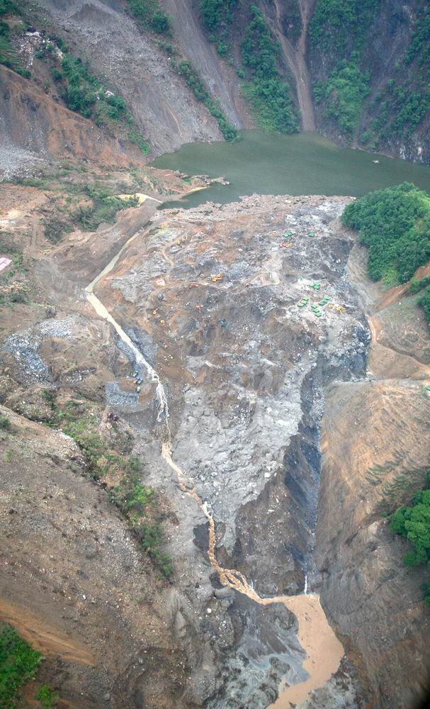
Now let’s look at the images that are available at the moment. In this post I highlighted one that appears to show a low level of flow. The image below has also appeared here. This clearly shows a level of flow that is well below 100 cubic metres per second (from now on let’s call this a cumec for convenience). Furthermore, Xinhua has now said that:
“Experts calculated that the water flows at seven to eight cubic meters per second, far more than the previous two cubic meters per second.”
Now the figure of less than 10 cumecs is absolutely consistent with the image above, which is clearly of this order. There is no way that this is the 100 cumecs required to balance average inflow.
So where is the excess water? I cannot work this out! Possibilities are (as I see them – there may be more):
1. In-flow is only <10 cumecs now because it has not rained for a day or so. I do not believe that this is conceivable;
2. The lake is filling so slowly that only <10 cumecs is escaping. This is possible – but suggests that there is a great deal more flow to come (which means that the current situation is a "phoney war");
3. The excess is being dealt with by seepage through the dam (in which case then the flow is now essentially out of control – this is not necessarily bad news, but it could be);
4. The volume of the lake has been seriously over-estimated (this does not seem likely).
There may be other options. Suggestions please?
Whatever, something does not add up here, and that is very worrying to my mind…
Finally, Ripen asks what the channel is on the right side of the above image? Is this a former attempt to cut a channel by the army? Is it erosion by seepage (there appears to be water within it)? Is it a natural feature associated with the landslide (I don’t believe this). Or is it something else (again, suggestions welcome please)?
In conclusion, something feels wrong here. I hope it is just that I am not getting a good picture of what is going on, which means that I am missing something vital. This could well be the case, or…
 Dave Petley is the Vice-Chancellor of the University of Hull in the United Kingdom. His blog provides commentary and analysis of landslide events occurring worldwide, including the landslides themselves, latest research, and conferences and meetings.
I didn’t do the math but I did look at before and after photos of the town and the river is substantial, more like the Thames at Henley than the mountain stream trickling over the landslide in these photos. Where is all this missing water? I had assumed that the flow would build as the lake level rose until it was ramming enough water through the channel to match the incoming flow. The low flow in the photos I put down to just being the first trickles before the flood.If it isn’t and your math is right then the water was flowing much faster at some point between the original slide event and now the only thing that would do that is if either and upstream dam burst and dumped its dam into this lake or another recent slide has caused an obstruction which is now forming its own lake. The problem is you would have thought someone on site might have noticed either of these events.Has anyone seen a photo of the river as it enters the lake, what does that flow look like?JJ
Indeed – in fact the flow in the Thames at Henley is slightly less than 100 cumecs actually (about 75 cumecs I understand). I think that your comment that this is just the initial low flow is right. If not, then as you say there is something else going on.
Dave if you are back in the UK and can get CCTV-9 – which I think is a freeview channel – they have some footage on the news of the water beginning to flow in the channel. They are talking about 10 cumecs but the film shows much less. The interesting bit is how much of the water was being lost down through the channel floor. There was even a little whirlpool where the water vanished down one hole. Obviously no lining at that point. They have some video at http://english.cctv.com/index.shtmlbut at present it is not caught up to the TV news footage.JJ
here’s the 10:40am Xinhua:Engineering soldiers have fired missiles to blast boulders in a man-made sluice channel to speed up the speed of water drainage. The lake started to drain on Saturday morning and water flowed at a speed of more than 10 cubic meters per second, far more than the previous two cubic meters per second, according to the quake lake relief headquarters in Mianyang City. The water level in the lake stood at 741.70 meters above the sea level at 9 a.m. on Sunday, still 1.33 meters higher than that allowing drainage, according to the headquarters.
here’s a second Xinhua: Soldiers were still widening and deepening a sluice channel to speed up the drainage with the help of 30 bulldozers and excavators. They were also digging a second sluice channel.
Outflow discharge from Tangjiashan is increased to 21.5cumec. (15:18 – Beijing time)(Source: http://66.163.168.225/babelfish/translate_url_content?.intl=us&lp;=zh_en&trurl;=http%3a%2f%2fnews.sohu.com%2f20080608%2fn257363870.shtml)
Dear All:The discharge was around 21 cms according to news report at 15:18 8th June local Bejing time.The army was bombed out a giantic boulder to increasing discharge. from this fact, I guess that the Chinese government try to make artificial dam break on Tangjiashan since they already moved out peoples.
I have to admit to being confused as to how this is meant to work. The channel lip is at an alt of 740m and water entering the lake after this point will be able to exit (allowing for a small additional head of water (C) to drive the flow through the sluice say 740 + 1.5). All well and good but then what? If this was a man made concrete dam this balance would be maintained indefinitely but the level would never drop. Obviously that is not what is going to happen here, the rock and soil are going to erode and release the bulk of the lake the question is how, when and how quickly. If you could control the erosion so the channel maintained its shape but gradually cut down through the land slide until it reached the old river bed you would have a perfectly controlled release. If it erodes primarily from the down stream end then the dam mass reduces without lowering the 740m+C or mass of water so the potential energy remains constant until catastrophic failure. Reality is presumably somewhere between these extremes. Given that the dam is made of friable soil with some rocks what is the normal method of erosion and failure for this type of structure? Are there any good videos/time lapse photography of previous similar attempts (obviously this channel over the top is not the first time this has been done) or film of simulations (computer or experimental)?Thanks JJ
Dear All:In principle, the inflow discharge is equal to outflow discharge based on fixed shape of overflow crest. Due to erosion process, The discharge of landslide lake will be larger than inflow during erosion state and reach to another stable channel then fixed its discharge characteristics. The inflow filling process of landslide lake depends on the upstream flow condition and volume of lake. Since everything happened very quickly, the volume of lake, outflow discharge and inflow discharge were all estimated by experience and based on old mountain map to calculated volume of lake, the uncertainty is very high for this kind case. From first two days situation shows that the landslide body of Tangjiashan is quit good which shows relatively stable by existing boulder underneath of flowing channel. The Chinese quit worry about the flow not flowing to manmade channel which is strange. Outflow of landslide lake actually depends on flow strength, structure of landslide body, slope of landslide face, seepage points, it is very difficult to predict the channel rout for this case. The flow is nor flowing to manmade channel is normal.For the Tangjiashan case, the dam body is around 800 m, the height is around 80 m, hence the slope is about 1/5 to 1/10 depends on how to calculate the length of dam body. For this very steep dam body with two or more seepage points specially one is at bottom of dam, this lake is highly dangerous and may breach any time from now on. The best cases is not to disturbed it from my point of view. Anyway, if it goes to quick dam break no one can stop it or change it. If it goes gradually erosion process then to keep it as now is better.
“Finally, Ripen asks what the channel is on the right side of the above image? Is this a former attempt to cut a channel by the army? Is it erosion by seepage (there appears to be water within it)? Is it a natural feature associated with the landslide (I don’t believe this). Or is it something else (again, suggestions welcome please)?”My guess is it is the edge of the slide. The river was coming around the hairpin and the slide flowed from off screen left in the photo ‘slopping’ across the river bed. Under this interpretation the darker material (left and centre) was deposited by the slide while the slightly redder material is the original bank (and seems to be of a piece with the bank as it extends below the landslide). I would be very surprised if this feature was man made as news coverage has been going on about the ‘600 men working 24/7 to dig the channel’ but by the look of this structure it would have needed a far more herculean earth moving effort than the channel. Water in the channel I take to be seepage finding its path of least resistance. If this natural groove was already in place I wonder why it was not used as the basis for the spillway channel.JJ
JJ, I am sure that this is the edge of the slide in terms of the fact that the red material is the bank and the grey material is the landslide mass. However, the edge of the grey material looks to me to have suffered erosion or some other form of removal – surely this sort of sharp edge would not be formed by movement of the landslide? Note how similart this looks to the much smaller area of erosion to the left where there is channel flow. The question is what caused this apparent mass erosion? The ongoing excavation for the channel can be seen in the left centre of the image – the excavators are visible if you look carefully. I note also that there are quite few ecavators etc at the top of the channel on the right.I remain confused!
Kung and Dave thanks for your explanations.Having made some guesses earlier I will now change up a gear and speculate wildly on a subject I know nothing about.Dave just to be sure we are talking about the same thing. The area of the dam between the new man made channel and the red/grey boundary looks like a discarded fletcher’s knapped flint with the sharp end pointed down stream. There seems to be ridge down the middle with the sides (particularly on the right of the photo) getting very steep at the down stream end. Where it butts onto the slope of the old red bank it forms a very pronounced V. What caused this?I do not see how it could be caused by erosion there has not been time unless you allow for an very unlikely scenario involving two slide events with a dam failure between.When granular materials flow they behave much like liquids and in a quake the shaking can cause liquefaction in sandy soil. The landslide flows down into the valley and its momentum causes it to slosh up against the step red wall and washes back settling with the ridgeline as a frozen interference wave crest. Final smoothing and polishing done by aftershocks and recent rains.I did warn you that I would be speculating wildly. JJ
JJInteresting speculation. Like you, I don’t see how this much material can have been eroded by seepage or suchlike. I wondered whether the landslide pushed the river water up ahead of it when it was emplaced. This water then drained off the landslide mass, creating this channel?
You beat me to it. I just returned to add exactly that thought. I had not allowed for the fact there was a whole load of water in the river at the time that would have been driven ahead of the landslide hit that red wall and fallen back. It accounts for why the grove gets more pronounced at the down stream end.I also tried an experiment Heath Robinson would have been proud of involving the lid of a keyboard box, 3Kg of salt and a pryrex cassorole dish with a river like cross section. Results inconclusive. Havent you got some unsuspecting undergrads you can send of with tons of gravel and sheets of plywood?JJ