
18 February 2015
Landslides from the 2015 Wilberforce earthquake in New Zealand
Posted by Dave Petley
Wilberforce earthquake
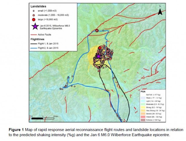
On 6 January 2015 a Mw=6.0 earthquake affected the Upper Wilberforce River catchment in South Island, New Zealand. Although this earthquake was not very large, its shallow depth (5 km) meant that the earthquake had the potential to generate landslides. On 8 and 9 January a team from GNS Science undertook a helicopter survey of the affected area to investigate whether landslides had indeed occurred. They have posted a brief report on the Landslides Reports part of the Geonet website.
The team mapped over 2000 individual landslides, the majority of which were situated in the area of greatest shaking:
.
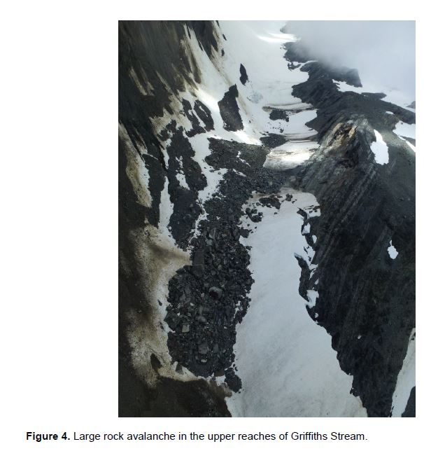
This is a naturally active landscape due to the combination of a dynamic climate and active tectonics. However, the earthquake clearly increased the level of landsliding, especially in the area that was affected by shaking of over 92 gals. The largest landslide had a volume that is estimated to have exceeded 140,000 cubic metres. In the report, there are several really good images of landslides triggered by the earthquake, of which I reproduce two here. This is a large and quite complex failure in the upper reaches of the Griffiths Stream:
.
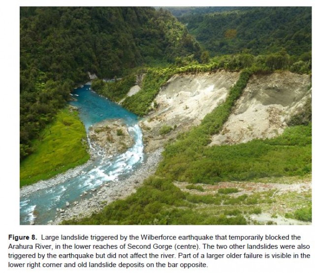
Perhaps the most interesting slide in the Wilberforce Earthquake occurred on the western side of the main divide on the Arahura River, which was briefly blocked. The landslide is estimated to have been about 25,000 square metres:
.
I am sure that the GNS Science team will now undertake a more detailed mapping and interpretation exercise for the landslides triggered by the Wilberforce Earthquake, and I shall look forward to seeing the results in due course. When analysed properly each of these events adds to our understanding of the controls on seismically-induced landslides, which require a great deal of further investigation.
 Dave Petley is the Vice-Chancellor of the University of Hull in the United Kingdom. His blog provides commentary and analysis of landslide events occurring worldwide, including the landslides themselves, latest research, and conferences and meetings.
Interesting event, quite far from any known active fault… Do you know whether a surface rupture was observed or not due to the earthquake, which seems very shallow looking at seismological data and the distribution of landslides.
Hervé
[Details of the mechanics of the earthquake are available. This page addresses your question:
“Seismologists had calculated that the rupture plane from Tuesday’s quake was near vertical, and measured about 5km long. The rupture had not broken the surface, but was likely to have come with 1km of it.” D.]