21 June 2013
The Kedarnath debris flow disaster in Uttarakhand
Posted by Dave Petley
Information about impacts of the early monsoon floods and landslides in Uttarakhand in northern India is slowly emerging. The tardiness of the information flow undoubtedly reflects both the exceptionally difficult terrain in this area and the magnitude of the damage, with for example few roads having been left intact. What is emerging is that the losses of this disaster are high – probably much higher than the current estimate of about 170 people – although at this stage it is hard to know if this will be a few hundred or more. A search on Twitter for either Uttarakhand or Kedarnath (see below) brings home the likely consequences. There are numerous reports, and photos, of people (and in some cases whole families) who have not been heard of since the disaster. In some cases there are young children missing,
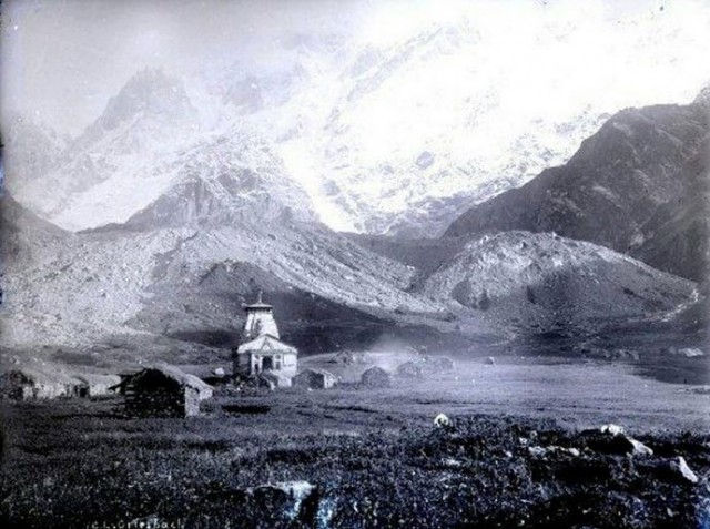
One of the largest impacts appears to have occurred at Kedarnath, a Hindu shrine high in the mountains, which at this time of year is an important pilgrimage destination. The site is just a short distance from the snout of two mountain glaciers, as this image from 50 or so years ago shows:
A couple of things to note here – first, the amount of debris below the glacier on the left side of the image suggests a pretty active, and quite steep, sediment transport system. Second, there are rocks and boulders in the fields in the foreground.
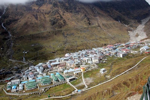
Given the number of people who make the pilgrimage to this site each summer, a degree of development around the temple was inevitable, although the pre-disaster images suggest that this has occurred in an entirely haphazard manner. There are some excellent images of the town here, from which this one is taken. The temple is on the right side of the image, surrounded by buildings:
..
..
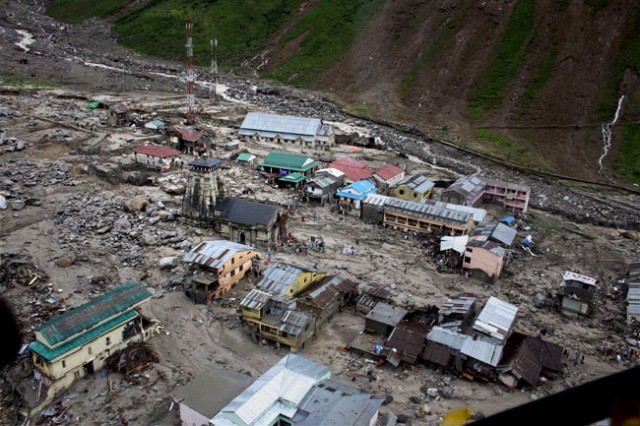
The level of destruction of the town by the debris flow is very high, and is quite shocking. There are several images of this floating around the internet, such as this one:
..
The upslope end of the temple, which has survived the flood intact though damaged, is buried in debris. Many of the surrounding buildings have been entirely destroyed. Given that many of these were hotels and hostels, which would have been full at this time of year, the high level of potential loss is clear.
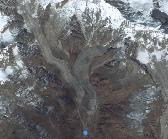
The question of course is what happened. Many Indian newspapers have a commentary, although it is not clear as to whether this is based on fact or speculation. Up-valley from Kedarnath, above the western glacier shown above, is a peak known as Kedar Dome. The suggestion is that the rainfall triggered a collapse event on the mountain, which turned into a debris flow downstream that struck the town. Certainly some of the images suggest that the debris flow came from this valley above the town, so the account is credible, but the degree to which it is verified is unclear. Unfortunately, the Google Earth imagery of this area was taken in winter, so it is covered in snow. Bing has a better image, which shows the geometry of the glaciers and peaks up-valley from the town (which is marked with the blue dot):
In terms of lives lost, this is probably the worst landslide since the August 2010 Zhouqu landslide in China. There are some similarities between the events.


 Dave Petley is the Vice-Chancellor of the University of Hull in the United Kingdom. His blog provides commentary and analysis of landslide events occurring worldwide, including the landslides themselves, latest research, and conferences and meetings.
You’ve received a nod, today, from Jeff Masters on his Weather Underground (wunderground.com) blog!
It is hard to believe that the flooding of Kedarnath is only due to early monsoon. The elevation of Kedarnath area is higher than 3,500m. I came to know that the flooding is due to outburst of Chirpatiya Lake (http://epaper.ekantipur.com/showtext.aspx?boxid=112958531&parentid=31512&issuedate=2362013) located about 3km upstream of Kedarnath. When I checked Google map and Google Earth, I could not find Chirpatiya Lake. However, there is Gandhi Sarovar, Google map (Name of the same lake is Chorabari Taal in the Google Earth), upstream of Kedarnath. It is difficult to estimate size, shape and volume of water based on Google map. Probably, outburst of this lake is the main cause of flooding of Kedarnath area.
Hi,
I already heard of the Huge Disaster to Kedarnath Debris Flood from [a commercial tour site].
Thanks for share such a fabulous information.