
19 July 2009
Intriguing landslide at Nachterstedt in Germany
Posted by Dave Petley
NB: I have posted an update on this landslide here.
A somewhat intriguing landslide occurred on Saturday at Nachterstedt in Germany (the location is 51.808 N, 11.343 E for those who are interested). The site is the edge of Lake Concordia, a flooded open cast coal mine:
 The mine apparently closed in 1991 whereupon it was converted into a recreation area. The lake was apparently created in 1994. Reports suggest that on Saturday the area received some rain, but that this was not exceptional in any way. The slide appears to have been rapid, with a volume of about 1 million cubic metres. Reports suggest that it created a mini-tsunami on the lake (not surprising given the images below), and that two houses were carried with the slide into the lake. It is thought that three adults were killed in one of the houses. The images of the site are quite remarkable:
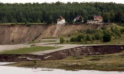
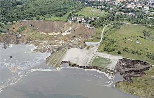 Image published in the LA Times providing an over-view of the site
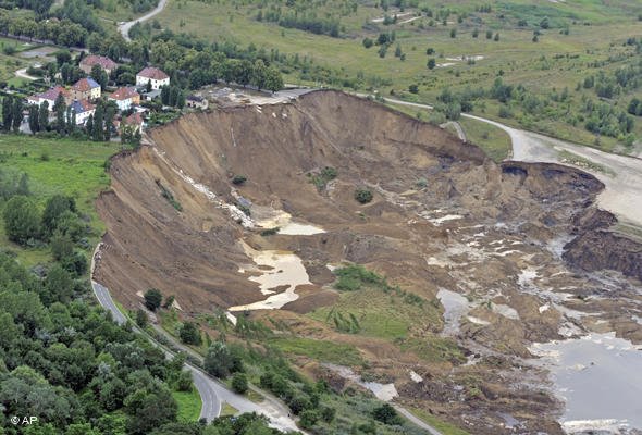 Image published in Deutsche Welle providing a more detailed of the landslide
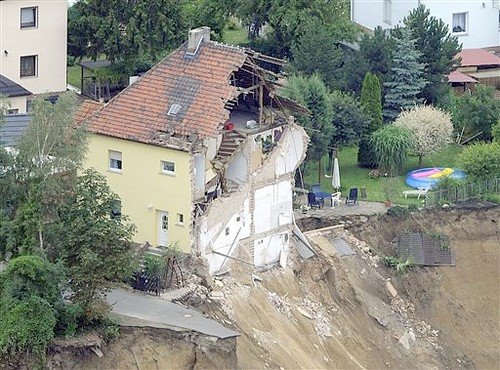 Close up published in the LA Times of one of the houses affected by the landslide
This is quite an intriguing slide, both in terms of the mechanisms of the slide and of the trigger. In particular it is not at all clear to me why this slope has failed when the weather was not wet. Central Europe had heavy rain a fortnight ago, so this might be an interesting starting point to ponder. Earthtimes suggests that the area might have been underlain by old mine adits, though this is not obvious from the images above. The middle image does show what appears to be shallow coal seams on the right side, but I can’t see any evidence of coal seams or abandoned workings elsewhere.
The Google Earth image of the site is quite high resolution. I have zoomed in below to show the area of the slide:
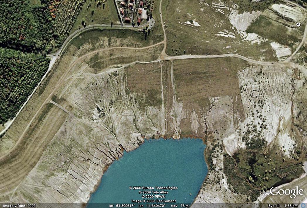
A few of things to note. First, the area that has slid appears to have been suffering some erosion of its toe. Second, this area also has extensive herringbone drains around the large gullies that cross it. I wonder why these gullies are there (they seem to be better developed than those elsewhere on the walls of the lake), and why these herringbone drains have been built. Is this an indication of a drainage problem. Third, there is another small slide on one of the images – see the right side of the Reuters image below:
This smaller slide also looks quite fresh (i.e. recent). It could of course be that this was triggered by the displacement wave, but it could also be an indication that there is a general stability problem. Finally, the presence of the ponds on the slide behind obviously displaced blocks suggests that there was some water in the slope.
The Earthtimes article suggests that the mine was still being progressively flooded, so it could be that the key issue here is instability under raised groundwater conditions.
NB: I have posted an update on this landslide here.
 Dave Petley is the Vice-Chancellor of the University of Hull in the United Kingdom. His blog provides commentary and analysis of landslide events occurring worldwide, including the landslides themselves, latest research, and conferences and meetings.
Also note that this is no “untouched soil” (I'm not sure about the correct English terms), but a overburden tip of the open-cast mine. These slopes have in some cases seriously failed both during mining (e.g. in this mine in 1959) and during flooding (e.g. at Lake Senftenberg) in a process called „Setzungsfließen“ (literally “settling flow”, a kind of liquefaction).The area is located at the margin of the Aschersleben salt anticline, so perhaps subrosion could also be a potential trigger. (There are several sinkholes in the wider area; however, mostly related to salt mining).
It does not appear that the wave produced by the slide was very large…as the images do not seem to show any sort of rack line. Interesting scenario with that smaller slide as well.
Google maps of Seelandstrasse: The drop into the mine from the road looks pretty steep to me. Wonder how long people have been ignoring the possibility of a slide?
My english is not so best but in "De morgen" (Flemish newspaper ) there was an article at 31 juli 2010 from Douglas Deconinck that explains that the place was in World war 2 a place where nazis had a hidden production centre of war gaz onther the soil. The place was known by the RAF and the entrance had been bombed. The entrance was at the 1/2 house at the picture.
My english is not so best but in "De morgen" (Flemish newspaper ) there was an article at 31 juli 2010 from Douglas Deconinck that explains that the place was in World war 2 a place where nazis had a hidden production centre of war gaz onther the soil. The place was known by the RAF and the entrance had been bombed. The entrance was at the 1/2 house at the picture.
My english is not so best but in "De morgen" (Flemish newspaper ) there was an article at 31 juli 2010 from Douglas Deconinck that explains that the place was in World war 2 a place where nazis had a hidden production centre of war gaz onther the soil. The place was known by the RAF and the entrance had been bombed. The entrance was at the 1/2 house at the picture.