
17 September 2009
Presentations on Day 1 of the International Conference in Commemoration of the 10th Anniversary of the 1999 Chi-Chi Earthquake in Taiwan
The Chi-Chi earthquake struck Taiwan on 21st September 1999. To remember that event, a range of organisations in Taiwan have organised a scientific conference aimed at sharing the lessons learnt from the earthquake. I was lucky enough to be invited to speak on landslides triggered by the event – my paper is tomorrow – but I thought I would also post on some of the most interesting presentations as they occur.
This morning there were a number of introductory and keynote speeches. I thought I would focus on two of them. First, Prof. Huang Jong-Tsun, President of the China Medical University, gave an overview of the impacts of the earthquake and the lessons learnt from a governmental perspective. He stated that the final death toll of the earthquake was 2505 people, with damage including the total destruction of 27,273 houses and 293 schools. He highlighted the post-event response with some highly impressive statistics:
- The national authorities released information on the epicentre location and the magnitude 102 seconds after the earthquake (!);
- The government mobilised the first army response teams within 13 minutes;
- At the peak, there were 460,000 people working on rescue and recovery operations.
The demands on the government in the five years recovery period were acute. In total, 17% of GDP was released for rebuilding, which meant that in the first three years 20,000 public engineering projects were required, costing US$3 billion. 10 million cubic metres of solid wastes was produced, about half of which was recycled. Schools were reconstructed using seismic codes that dictated that the should be able to withstand peak ground accelerations of 0.41g, equivalent to the design criteria for a small nuclear power station.
He also touched on some more nebulous but very interesting issues:
- The government discouraged the desire amongst the people to create multiple landmark memorials. The strong sense was to focus attention on looking forwards not back.
- Studies showed that the suicide rate amongst those affected by the earthquake increased by 40-50% in the aftermath, but quite quickly returned to normal levels;
- Full post-traumatic stress disorder affected 9% of the affected population, but reduced to 3% within three years
- Substantial legal problems arose with redefining property values as the landscape was altered to such a high degree;
- Landslides and sediment delivery represented major ongoing legacies that in some cases have rendered the reconstruction of infrastructure unviable. In consequence a decision has been made to wait for the landscape to naturally stabilise.
Finally, Prof. Huang highlighted a major problem moving forwards, which is how to make decisions under situations of ambiguity. He gave the example of decisions about the evacuation of landslide-prone villages as typhoons move towards the island. Given the impact of typhoon Morakot, this is an important issue that needs work.
The second presentation that I will mention briefly is that of Prof. Gordon McBean, who holds a Chair at the University of Western Ontario in Canada but who is also the Chair of the Science Committee of the Integrated Research on Disaster Risk (IRDR) programme, which is an initiative by ICSU. He used some statistics to demonstrate that disaster impacts are increasing and so to justify (quite correctly) the proposed programmes. The programme aims to drive a shift in focus from response – recovery to prevention – mitigation by driving a series of large science programmes covering characterisation of hazard, vulnerability and risk, and effective decision-making, with a planned legacy after ten years of enhanced capacity to address hazards and to make informed decisions. This is of course a highly worthy initiative that I support fully, but I do hope that they but considerable focus on the translation of knowledge from scientists to practitioners and policy-makers. So often the issue is not a lack of knowledge but rather this exchange process. In my view it is this that is the greatest challenge of all at the moment.
15 September 2009
Interesting landslide footage from La Jolla, California
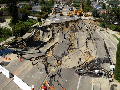 Image from here
The La Jolla landslide in San Diego California occurred in October 2007, destroying three houses and a road, and leaving many more damaged. The landslide is currently the subject of a lawsuit that was filed by the householders. I am not going to comment further on the slide whilst this is going on, but as part of the evidence in the case some mobile phone footage has emerged of the slide as it occurred. This footage is unusual in that it covers a progressive, non-catastrophic slide, essentially showing the tension cracks opening as the slide occurred. The footage can be viewed here. The complete (8 minute) footage, available on that page, is worth viewing.
Fatal landslides in S. Asia in 2009
The key driver of landslides in S. Asia is the SW (summer) monsoon, which brings prolonged and sometimes heavy rainfall across much of the Indian subcontinent. This year the monsoon has been comparatively weak so far, with only a month or so to go. Indeed, the Indian Institute of Tropical Meteorology maps of the total monsoon rainfall give a picture of considerable rainfall deficit, although it should be noted that heavy rainfall in the last few days may have started to reduce this: So I wondered to what degree this is being reflected in the landslide pattern for S. Asia. The graph below shows the monthly occurrence of rainfall-induced fatal landslides for S. Asia for the period 2002 to 2008, with the 2009 figures up to the end of August included (click on the graph to view a bigger version in a new window):
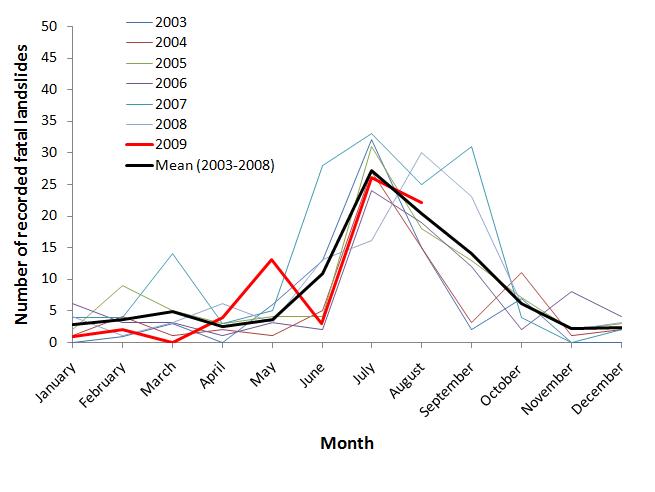 The black line is the long term average, and red line is 2009. I have used a lighter line for previous years to make the graph clearer. As I have pointed out previously for similar graphs, this graph shows clearly the impact of the monsoon, with a clear, asymmetric summer peak and low levels the rest of the year. Note that there is some inter-annual variation, with 2007 and 2008 varying somewhat from the patterns seen in other years for reasons that are not at all clear.
So what of 2009? Well, perhaps surprisingly 2009 shows a very unexceptional picture. May was somewhat above average, and June below, whilst July and August are almost exactly as per the long term mean. There is some evidence that in previous El Nino years September has been the month with the most intense rainfall in S. Asia, so it will be interesting to see what is to come.
14 September 2009
A small collection of interesting landslide images
A quick post today – I thought I’d post a small selection of impressive landslide images that I have come across recently:

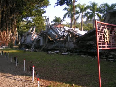
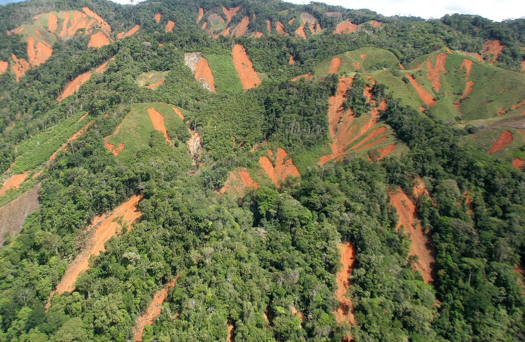 Landslides resulting from deforestation in Taraza, Antioquia, Colombia, from here.
 A long runout landslide from Sichuan in China, from here.
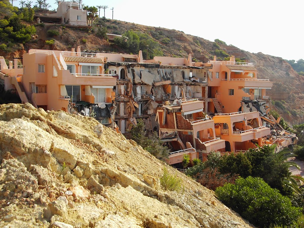 After effects of a landslide on the island of Ibiza in Spain, from here.
13 September 2009
On the loss of life in landslides during the 1949 Khait earthquake
![]()
Regular readers will know that one of my interests lies in trying to get a better understanding of the loss of life associated with landslides. A key realisation of this work for me has been that earthquake-triggered slides cause a very substantial proportional (probably in fact the majority) of fatalities is mass movement events. Unfortunately our understanding of seismically-driven landslides, and their impacts, remains poor, certainly in comparison with rainfall induced slides. For that reason, work to re-examine past seismically-driven events is very welcome, helping us to get a much better understanding of the range of processes and impacts in these events.
One significant but until now slightly elusive such event has been the 1949 Khait earthquake. This was a Mw=7.4 event on 10th July 1949 in the Tien Shan mountains of what is now Tajikistan, but was then the Soviet Union. The timing and location of this event, soon after the war in an area about which the Soviet Union was very secretive, has meant that it has been very difficult to determine any details about the landslides that were triggered in the earthquake. However, some rather speculative reports have suggested that the impacts were very large – for example this article in Mountain Research and Development reported a huge landslide at a site that it termed Borgulchak Rock. This slide was reported to have travelled 12 km. Some reports, such as the Wikipedia article on this landslide, have suggested a death toll as high as 28,000 people, although to be fair this may well be something of a misinterpretation of the original source.
An article in press in the journal Engineering Geology, by Steve Evans and colleagues (Evans et al. 2009 in press) seeks to re-examine the landslides triggered by this earthquake. Unusually for a science paper the article is a ripping-good read. The paper re-evaluates the Khait landslide, and the other large slide that was triggered in the earthquake, providing a rational analysis of the likely impacts of the mass movements.
First, they look at the Khait landslide (termed in the paper as a rockslide / loess flow), which is still clearly visible in the landscape, even on the low resolution Google Earth imagery available for this area:
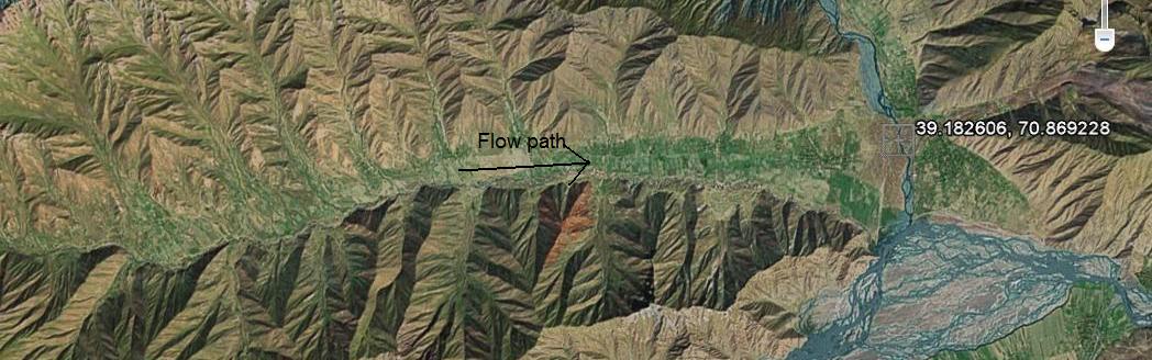
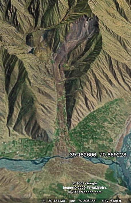 For the Khait landslide they conclude that the volume was probably rather lower than earlier estimates have suggested. The other landslide considered is a very large and complex flowslide that swept down the Yasman Valley, covering about 20 km. This slide had multiple source areas on the southern side of the valley:
 They conclude that this is a rather destructive loess flow slide with a volume of about 245 million cubic metres. Remarkably it travelled over a slope with an angle of just two degrees!
Evans et al. (2009) then consider the fatalities caused by the landslides. By looking at contempory reports of the population of the Khait area and census data on settlement size and population density they reject earlier estimates of the loss of life. For the Khait landslide itself they conclude that about 800 fatalities is probably a reasonable estimate – note that this very considerably less than earlier estimates. For the Yasman Valley flowslide they estimate about 4,000 fatalities, and they determine that there were probably a further 2,400 deaths. This gives a total fatality count of about 7,200 – far lower than previous counts, but still substantial of course.
In conclusion, this is a very important contribution, filling in another gap in our understanding of previous landslide impacts. Steve and his colleagues have also just published a similar paper (Evans et al. 2009) re-examining the 1960 Huascaran rock avalanche in Peru. This will be the topic of an upcoming post.
Reference
Evans, S., Roberts, N., Ischuk, A., Delaney, K., Morozova, G., & Tutubalina, O. (2009 in press). Landslides triggered by the 1949 Khait Earthquake, Tajikistan, and associated loss of life Engineering Geology DOI: 10.1016/j.enggeo.2009.08.007
Evans, S., Bishop, N., Fidel Smoll, L., Valderrama Murillo, P., Delaney, K., & Oliver-Smith, A. (2009). A re-examination of the mechanism and human impact of catastrophic mass flows originating on Nevado Huascarán, Cordillera Blanca, Peru in 1962 and 1970 Engineering Geology, 108 (1-2), 96-118 DOI: 10.1016/j.enggeo.2009.06.020
12 September 2009
Coastal erosion – the last groyne problem
One of the most emotive topics for local authorities in the UK is that of coastal erosion. Over the last few years in Britain we have increasingly taken a view that coasts should only be defended where absolutely necessary – elsewhere erosion should be allowed to occur at a “natural” rate. In most cases the view has been taken that protection of coasts in which erosion will affect domestic properties (i.e. peoples’ houses) does not qualify as necessary. This is particularly harsh for those whose properties are affected by erosion – in the UK domestic insurance does not cover erosion and there is currently no compensation scheme for people whose houses are affected by erosion. Even worse, when the house becomes dangerous the local authority will often take possession of the hose and demolish it. Guess who gets the bill for the demolition…
One of the key reasons for choosing not to protect coasts is the so-called “last groyne” problem. This occurs at the point of the last (down drift) part of the coast that is protected. Here, the coastal protection updrift typically starves the coast of sediment that would normally provide some protection against erosion, leading to greatly increased erosion rates at this point. I was playing with the historic imagery feature on Google Earth this week and came across a very clear example of this problem, from the east coast of Britain.
Here is an image collected in 1999 of the site in question. As ever, click on the image for a better view in a new window:
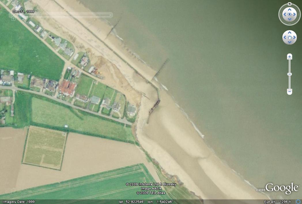
Here, longshore drift is from the northwest to the southeast, such that the groyne (sea defence) in the centre of the image is the last of the chain. Most of these sea defences have been in place for half a century. What should be immediately obvious is the way that the coast steps back at the point of the last groyne, indicating the much higher erosion rate at this point.
Let’s now zoom forward just seven years to an image that was taken in 2006:
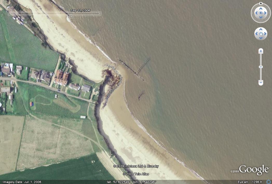 The change in this period is quite startling when you look closely. First, you will see that the area previously affected by enhanced erosion has retreated further. The sea defence has broken down and three houses have been lost. It appears that some rock armour has been dumped at this point to try to reduce erosion. The sea has also breached and destroyed the coastal defence just to the NW of this point, and as a result the coast has started to erode. In consequence a whole series of properties have been lost along this frontage.
The town in question is called Happisburgh. The residents have a campaign to try to have sea defences constructed, with an excellent website.
Perhaps most startling is this image, from a sequence of aerial photographs, which shows the same location in 1986:
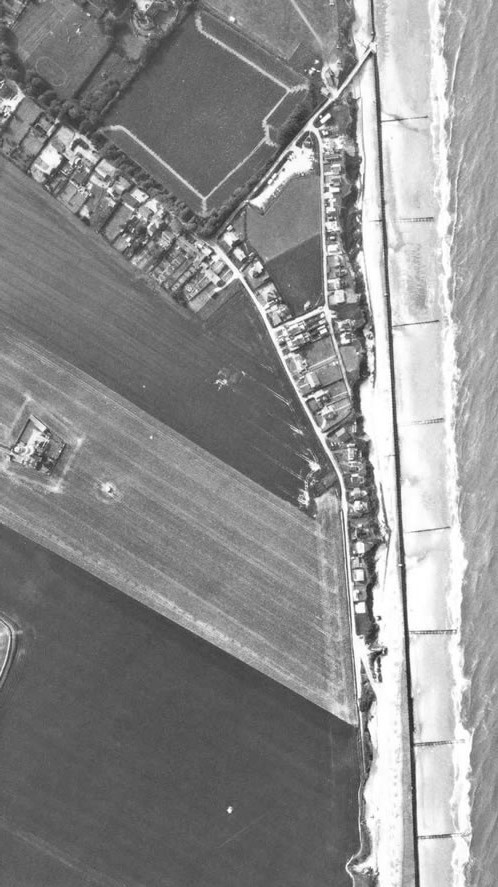 At this point the groynes were intact all the way down the coast, and the current step back is not present. Therefore, the big step back in the coast that is seen in the first image above occurred in just 13 years.
11 September 2009
Real time landslide monitoring in New Zealand – the Utiku landslide
I have posted previously about the near real time landslide monitoring project that is being undertaken on the Taihape landslide by the GEONET team in New Zealand. The most amazing aspect of this project is that the monitoring data is streamed onto a web server and can then be viewed using a rather neat online graphing package (available here).
The great news is that the team have now instrumented another landslide on North Island, this time on a slightly more active slide at Utiku, which is not far from Taihape. Once again the data is being put online in near real time, and once again it can be viewed using the graphing package. This is available here.
This is how Geonet describes Utiku:
“The Utiku landslide has been classified as a deep-seated translational block-slide earth-flow. This classification refers to the characteristics of the landslide. Deep-seated refers to the depth of movement (depth to the landslide slip-plane); the slip plane of the Utiku landslide has been recorded at 20 m below ground level at the toe (bottom) and increasing to 65 m towards the back scarp (top). The term translational refers to the movement style of the landslide, where it moves as a relatively intact mass (raft) of material, along a planar zone of weakness. In this case, the zone of weakness corresponds to a thin clay layer thought to represent a bedding plane within the local sandstone . The term block-slide and earth-flow describe the landslide structure and movement mechanisms.”
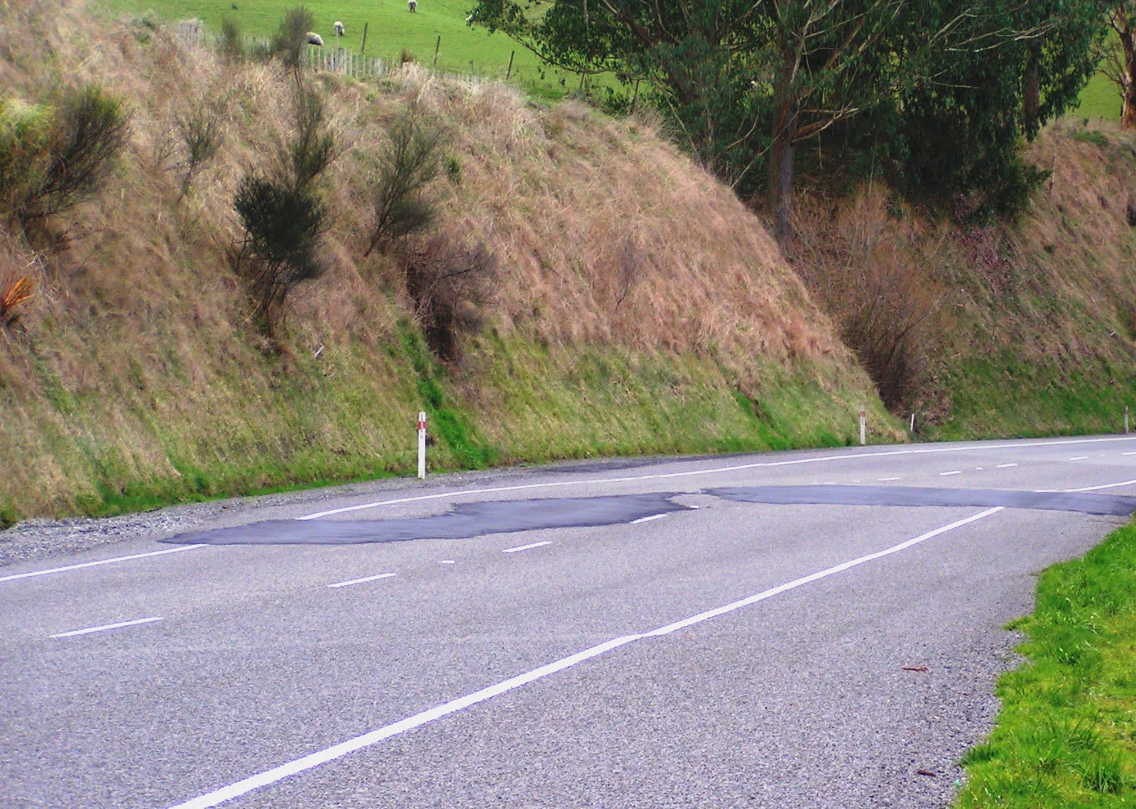
This is quite an old slide (at least 1,800 years, and possibly much older), but it remains active. The road that crosses the slide shows some minor signs of deformation that has required patching:
 It will be very interesting to see how this landslide behaves as groundwater levels increase.
10 September 2009
Successful anticipation of the Rest and Be Thankful landslide in Scotland
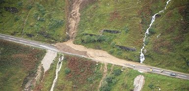
The Scotsman is reporting today that engineers anticipated the occurrence of the Rest and Be Thankful slide this week, shutting down the road before the slide happened. The report suggests that the intense rainfall prompted an inspection of the hillside by engineers because of the previous occurrence of landslides at this site. Once there, the engineers noted that the water in the burn (stream) was discoloured and the slope showed signs of movement. As a result they used existing traffic lights to close the road, whereupon 800 tonnes of material came down.
This is a rare and significant example of successful short-term anticipation of a landslide event. The engineers deserve praise for their actions. The damage to the road was also minimised by existing protection on the road.
9 September 2009
Video of the Rest and Be Thankful landslide site in Scotland
The BBC has a short video on its website of the Rest and Be Thankful landslide site in Scotland. It can be found here.
8 September 2009
New landslide at the Rest and Be Thankful in Scotland
Probably the most infamous landslide event in recent years in the UK occurred in Scotland in August 2004 when a series of landslides occurred, including one on the A83 at the rather delightfully named “Rest and Be Thankful”. The same area was affected again by landslides in 2007. The images from the time were quite spectacular, as shown by the BBC at this web page, which is the 2007 slide:
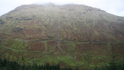
The slide here, and several other slides on the same day in 2004, prompted quite a major study into landslides on the Scottish Highway system. The report is online here.
The BBC is this afternoon reporting that the road is once again blocked by landslides.:
“A long stretch of the A83 has been shut after a landslide at the Rest and be Thankful road, west of Loch Lomond. Police said westbound traffic was being diverted at Arrochar while eastbound traffic was being diverted at Inverary. According to reports, some heavy vehicles are stuck in mud which has come down from the hillside.”
For those interested there is a nice background to the 2004 events here, whilst the BGS have information on the 2007 landslide here.
 Dave Petley is the Vice-Chancellor of the University of Hull in the United Kingdom. His blog provides commentary and analysis of landslide events occurring worldwide, including the landslides themselves, latest research, and conferences and meetings.
Recent Comments