
11 May 2010
Possible flowslide (not a sinkhole) in St Jude, Canada
The Canadian media is reporting the case of a “sinkhole” that developed in St Jude, 77 km to the north of Montreal, last night. The sinkhole included a family house, with four people inside. At the moment these occupants are reported to be missing.
The Montreal Gazette has a photo gallery of the site. One of the photos is this one:
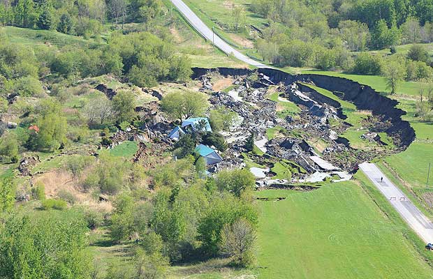
Based upon this image this does not look like a sinkhole but instead to be a quick clay slide, probably in Leda Clay. Such slides are not uncommon in this area. I have covered a previous example in Norway on this blog. The famous Rissa quick clay landslide in Norway is available as a video here if you want an idea of the extreme end of this type of failure.Quick clay slides often occur on very low angled slopes, and can be triggered through ground disturbance which causes the clay to restructure, allowing it to flow.
At the moment I am unsure of the exact location of this event, but St Jude is at 45.77 N, 72.99 W.
Hat-tip to Peter Weisinger for highlighting this one.
9 May 2010
The landslide at Attabad – new videos of the spillways and the drowning land upstream
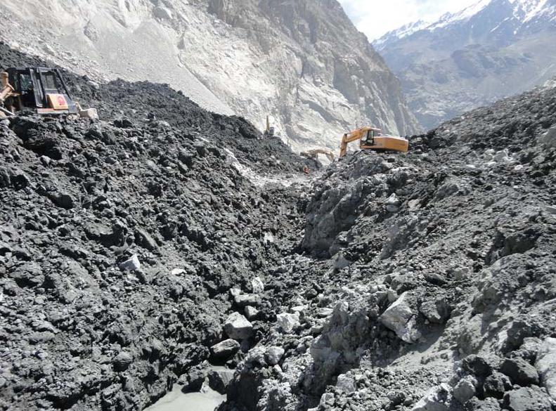
The lake behind the landslide at Attabad in Hunza, Pakistan continues to fill, meaning that we are probably only a fortnight or so away from the maximum point. I have not had an update from either NDMA or FOCUS for 48 hours, so am unsure as to how things have developed in the last two days. However, The Pamir Times has tonight posted three videos on Youtube that are worth watching. The first shows the spillway on 8th May:
This shows just how close to the top of the dam the water level has now reached. The second and third show the impact of the rapidly rising water level:
The sight of people destroying their own homes to recover building materials is pretty dreadful. Remember that most people in this area live on the basis of cash crops, and that their only real assets are their buildings, their land and their crops. For this reason, regardless of what happens at the spillway, the Attabad landslide is a disaster for the people of Gojal.
Landslides in art: Part 6 – this time a song!
Regular readers will have seen the occasional posts in which I feature the occurrence of landslides in art (previous examples here, here, here and here). You may also remember that I featured a project by artist Kane Cunningham to turn a landslide / erosion threatened house at Knipe Point in Scarborough into a work of living art.

Well, singer-songwriter Anne-Marie Sanderson has written a song about the project / house, which you should be able to view below via Youtube:
Whilst there are lots of songs that use the term landslide figuratively, this is the first one that I have heard that is actually directly about a landslide. I would be interested in any other examples anyone may have.
Anne-Marie’s website is here. Don’t blame me if the background gives you a migraine!
8 May 2010
Inflow to the landslide lake at Attabad
The lake at Attabad continues to fill quite rapidly, with the water level now rising at close to 1 metre per day, as this graph using Focus data shows:
The remaining freeboard is now 15.5 metres. At the current rate of increase, water will flow across the spillway on about 22nd May. However, Young and Hewitt (1990) provided a hydrograph of flow in the Hunza (apologies for the poor quality of the image) and rivers downstream:

The data for the Hunza are from Dainyor, which is downstream of Attabad at the point at which the Hunza joins the Indus near to Gilgit. Thus, the recorded flow should be higher than at Attabad. However, the key point is that the June discharge is about five times that of May. Thus, we might reasonably expect to see a rapid rise in inflow over the next few days, which may bring forward the date upon which water flows across the spillway. Meanwhile, the most recent Focus weekly update contains the following two images of the current state of the spillway:
Reference:
G.J. Young and K. Hewitt, 1990. Hydrology research in the upper Indus basin, Karakorum Himalaya, Pakistan. In: L. Molnar, Editor, Hydrology of Mountainous AreasIAHS Publ. vol. 190, Wallingford, UK pp. 139–152. Available here.
6 May 2010
Forthcoming meeting at the Royal Geographical Society: Natural disasters: how can we improve?
The RGS will host a meeting on 25th May entitled:
“Natural disasters: how can we improve?”
Chair:
Martin Bell, UNICEF Ambassador for Humanitarian Emergencies
Speakers:
Dame Barbara Stocking, CEO Oxfam GB
Cameron Sinclair, Founder of Architecture for Humanity
Date: 25 May 2010, 7pm
Location: Royal Geographical Society, London
Tickets: £10, £7 (RGS-IBG members)
Details: www.21stCenturyChallenges.org
EGU Day 3 – Dave Keefers Sergey Soloviev lecture

On Wednesday morning I attended the presentation by Dave Keefer, the winner of the Sergei Soloviev medal. Dave has single-handedly defined the field of seismically-induced landslides, an area of great importance. In the lat five years alone such slides have killed over 50,000 people, and the ongoing landslide activity in the aftermath of big earthquake events means that the legacy of the shaking continues for decades after the main shock.
Dave started by showing that in general losses from natural hazards are increasing both in social and economic terms. Seismically-induced landslides are a key component of this. Dave looked at the historic development of research into seismically-induced landslides, dividing the last century into three key phases. The first era was defined as from the beginning of time to 1947, during which time it was increasingly recognised that there was a problem with earthquake induced landslides. However, documentation of events was patchy in almost every case,
The second era was defined as 1948 to 1988, during which “complete” mapping of landslides was initiated, including the development of quantification of landslide impacts. He highlighted three key events in this period:
1964 Prince William Sound earthquake in Alaska, which saw landslides over an area of 270,000 square kilometres, causing 56% of the economic losses and at least 45 0f 130 deaths in the earthquake.
1970 Yungay earthquake in Peru that triggered the Huascaran landslide, which killed 6000 people and travelled over 180 km.
1976 Guatemala earthquake ,which triggered over 50,000 landslides over an area 16,000 square kilometres.
Dave used these data to write 1984 paper based upon 40 historic earthquakes with good data across a wide range of magnitudes with a broad geographic distribution. This paper is of course a classic and, remarkably, subsequent analyses using modern techniques to generate far better datasets have hardly changed the main findings. It is rarely reported that the study also looked at landslide type, finding that 86% of triggered mass movements were disrupted slides and falls on very steep slopes.
Dave also highlighted the importance during this period of the development of the Newmark analysis, which then allowed the development of hazard maps over large areas.
Finally, Dave highlighted the modern era, which has seen detailed mapping of landslide events plus site specific data collection, plus some palaeo analyses. Dave highlighted three key earthquakes:
1989 Loma Prieta, which saw the first GIS based landslide inventory, in this case for the Santa Cruz mountains. This showed an exponential decay of landslide concentration with distance from epicentre and from fault.
1994 Northridge: similar analyses but more detailed than Loma Prieta, but this time developed to produce a regional scale Newmark analysis based hazard map, calibrated using the actual landslides.
1999 Chi—Chi earthquake in Taiwan, which remains the best studied seismically-induced landslide event of all time. Most up to date analyses suggest that 13,000 landslides were triggered. Dave described this events as unleashing an explosion of research on this topic.
Finaly, Dave highlighted the need to overcome our current limitations of knowledge, in particular highlighting a number of research needs:
1. Urgent need to locate accelographs onto slopes to measure ground motion modification by slope properties;
2. The need to develop automated mapping of landslides from remote sensing to allow the development of proper inventories;
3. The need to further develop slope-stability and hazard mapping techniques;
4. More detailed modelling and analysis of landslide mechanisms
5. The need for complete mapping and characterisation of a great (M>8) earthquake, when such an event occurs.
In questions Dave highlighted the urgent need for better data from landslide inventories and on site specific effects.
Accelerating rate of filling at the Attabad landslide in Hunza, Pakistan
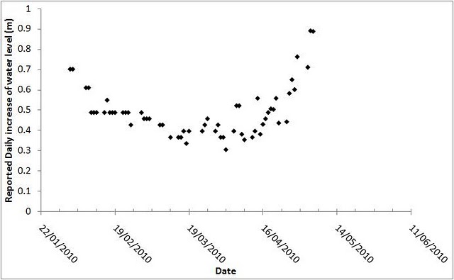
The rate of inflow at the Attabad landslide has now started to increase appreciably as warming and snowmelt really get underway. The graph below shows the daily rate of water increase, using data from the Focus measurements (the daily data are available on my monitoring website):
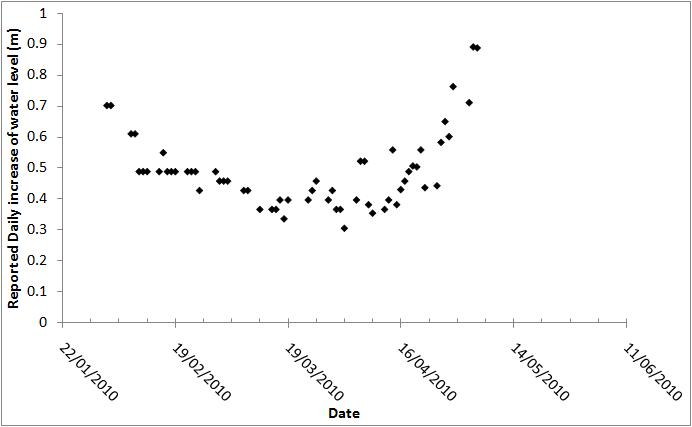
The rate of increase for the last two days with data has been 89 cm per day. At that rate the water will overtop on about 24th May, although clearly there remains considerable uncertainty around this date. It is unlikely that we have yet achieved maximum inflow rate, so the date could easily move forward again.
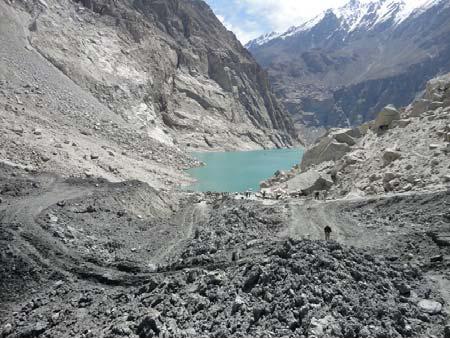
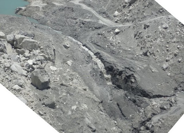
As of yesterday the remaining freeboard was just 17.64 metres, as this Pamir Times image from a couple of days ago shows:

Just above the boats you will see that there is a small terrace on the landslide deposit. This is the water level point at which I recommended in my report that should trigger the move to an increased alert state. We should now start to see an increase in seepage rate as the thickness of the landslide barrier decreases markedly.
5 May 2010
EGU Day 2 – afternoon sessions on vulnerability, plus Italian landslide statistics
In the afternoon of Day 2 I decided to focus more on the human / vulnerability side of natural hazards, and went to two sessions on Social Sciences in Natural Hazards Research. First up was Katie Oven from Durham, with a number of co-authors , who talked about landslide hazards in Nepal . Now I was the principal supervisor of this research, but I am going to write about it anyway, so forgive me but understand my bias! Katie set out to look at some fundamental questions around the interactions between landslides and people in upland Nepal.
Katie started with the work that we published a few years ago on the occurrence of fatal landslides, which we wrote up for Natural Hazards (paper available here), and in particular on the reasons why Nepal is suffering an increase in landslides. The question is whether this is due to physical problems – e.g. climate change, deforestation – or human factors – e.g. population growth, urbanisation. The key issue that underpins this is that landslide vulnerability is far less well understood than is the physical hazard. So Katie wanted to know who is vulnerable to landslides and why are they vulnerable. To do this she looked at the upper Bhote Kosi landslide in Nepal. In this paper she presented three case studies, all of landslide prone communities. She found that in recent years (the last 20-30 years or so) there has been a major migration of people from upper hillslope communities to live by the road. This changes their exposure to hazard, in particular putting them into the path of high energy flows that are very capable of killing people. It is clear that people have made a conscious decision to increase their vulnerability to landslide risk because the location decreases vulnerability to other risks – i.e. they have better access to health, education, income-generating opportunities.
So, the key thing is that there is a tendency in the science community to over-estimate the role of natural hazards compared with other risks in the lives of the vulnerable people. Decisions might appear to be illogical viewed through only the prism of hazards, but once the range other risks are taken into consideration moving into an area of higher hazard looks entirely sensible. This of course means that we probably need to think differently about how to manage hazards in a way that really works for people. Unfortunately, all bets will be off when Nepal suffers the earthquake that is well overdue; that is a truly terrifying possibility, but again the risks to individuals need to be considered alongside the everyday risks that the people in this are face.
The next talk that caught my eye was that of Marjory Angignard and her co-author looked at now affected people perceive natural hazards. This study came out of the Mountain Risks training network project of 17 PhD students and post-doctoral researchers across Europe, working together to try to understand differences between public and expert cultures of risk. The study presented here compared Italian and French perceptions of risk from natural hazards, and found quite large differences not only in the hazard perception (not surprising given that the hazards are different) but also that people’s source of information differed substantively between the two, presumably representing deeper cultural differences. This means that there is no silver bullet that solves the communication problems; for each area the approach needs to be locally tailored.
Eric Lindquist and Katrina Mosher-Howe looked at natural hazard problem and solution definition in the news media, based upon a study of reporting of Tropical Storm Allison in the USA. Alison brought five days of rainfall from 5th to 9th June 2001, inducing 22 fatalities, 70,000 houses flooded, the death of 30,000 lab animals in a flooded basement, and $5 billlion of damage. In particular the storm caused very serious flooding in Houston. The study looked at 500 news articles on the event from the Houston Chronicle, examining them for variables such as cause, impact, damage, blame, solutions, manifestations of harm, etc.
A number of things came out. First, as expected there was a very clear exponential decay in coverage of the event over several years. Most media attention focussed on home-owners, even though this group was not the most affected. News articles tended to blame local government, there was little blame to developers because this is a very powerful group in Houston.
Major causes articulated the causes as being associated with physical/topographic factors and drainage problems – i.e. the hazard was seen as an external process imposed on a vulnerable population. Lots of emphasis was placed on poor infrastructure – e.g. poor drainage, etc. However, the solutions proposed in the articles focussed on “soft” approaches – i.e. economic, development, social, infrastructure, political changes, and suchlike.
They then looked at what actually happened in the aftermath of the event. Interestingly, most of the changes were associated with “hard” engineering – for example Harris County spent $750 million on improvements and the City of Houston spent $250 million. The soft solutions were poorly resourced. Thus, there was a mismatch between the proposed solutions and actual answers.
Very interesting stuff, but I wonder whether that newspaper has a particular political perspective that might have influenced its coverage?
Alessandro Trigila and colleagues focussed on the impact of landslides on urban areas and infrastructure in Italy, based upon the nationwide, amusingly titled but hugely impressive IFFI project. Some of the statistics on landslide hazards in Italy defy belief:
- The project has documented 480,000 landslides covering 20,700 square km
- Landslides represent 6.9% of the land mass of Italy
- 5708 Italian municipalities are affected by landslides, representing >70% of the total number.
- 992,403 people are at risk, representing 1.7% of population).
- There are 43,621 hazardous locations along the transportation network.
The Attabad landslide: well, that's me told then!
The Pamir Times is running an interesting story today that clearly puts me in my place! Here it is:
Posted on May 5, 2010 by Pamir Times
PT Report
Gilgit, May 4: The report prepared by Dr. David Petley is wrong and the lake formed on Hunza River is not going to burst. Government experts have rejected any chance of lake burst.
These views were expressed by the Deputy Commissioner of Gilgit district while briefing the media about evacuation plan set up for downstream areas, at his office. He said that necessary measures are being taken because 1300 households in Hunza – Nagar and Gilgit district would be affected by the a flood that is likely to triggered by over-topping of the lake.
“There is no chance of lake outburst and we request the local populations to stay calm”, the DC, who also is the director general of district disaster management authority.
“Government of Pakistan, FOCUS Pakistan and other relevant institutions have teamed up to ensure safety of lives and property to the optimum in case of heavy flood that might be caused by over – topping”, Asad reportedly said. He also said that the 10, 000 internally displaced people will be sheltered at nine relief camps after evacuation to safer locations.
Commenting on removal of the Bailey Bridge in Danyore and the resulting isolation of Danyore and other localities he said that the Jalalabad – Danyore Road will be paved and expanded within a week to ensure supplies for Hunza – Nagar district.
The commissioner emphasized that the measures are being taken as precaution.
It is pertinent to note here that Dr. David Petley has calculated June 9 as a probable date for the spillover to take place, while also saying that the actual date might be earlier depending on volume of the water in the Hunza River. He has also said that there is a substantial risk of dam burst with the passage of time.
Three points to note. First, my report does not say that a burst is inevitable, but that the risk is substantive. Second, my report recommends precautionary actions. Third, it is a brave man who says “there is no chance” about any natural system.
There are many readers here who are well-qualified to comment on the situation, so I invite you to do so. To help I reproduce here an image from the Pamir Times yesterday showing the spillway:
The Attabad landslide: well, that’s me told then!
The Pamir Times is running an interesting story today that clearly puts me in my place! Here it is:
Posted on May 5, 2010 by Pamir Times
PT Report
Gilgit, May 4: The report prepared by Dr. David Petley is wrong and the lake formed on Hunza River is not going to burst. Government experts have rejected any chance of lake burst.
These views were expressed by the Deputy Commissioner of Gilgit district while briefing the media about evacuation plan set up for downstream areas, at his office. He said that necessary measures are being taken because 1300 households in Hunza – Nagar and Gilgit district would be affected by the a flood that is likely to triggered by over-topping of the lake.
“There is no chance of lake outburst and we request the local populations to stay calm”, the DC, who also is the director general of district disaster management authority.
“Government of Pakistan, FOCUS Pakistan and other relevant institutions have teamed up to ensure safety of lives and property to the optimum in case of heavy flood that might be caused by over – topping”, Asad reportedly said. He also said that the 10, 000 internally displaced people will be sheltered at nine relief camps after evacuation to safer locations.
Commenting on removal of the Bailey Bridge in Danyore and the resulting isolation of Danyore and other localities he said that the Jalalabad – Danyore Road will be paved and expanded within a week to ensure supplies for Hunza – Nagar district.
The commissioner emphasized that the measures are being taken as precaution.
It is pertinent to note here that Dr. David Petley has calculated June 9 as a probable date for the spillover to take place, while also saying that the actual date might be earlier depending on volume of the water in the Hunza River. He has also said that there is a substantial risk of dam burst with the passage of time.
Three points to note. First, my report does not say that a burst is inevitable, but that the risk is substantive. Second, my report recommends precautionary actions. Third, it is a brave man who says “there is no chance” about any natural system.
There are many readers here who are well-qualified to comment on the situation, so I invite you to do so. To help I reproduce here an image from the Pamir Times yesterday showing the spillway:
 Dave Petley is the Vice-Chancellor of the University of Hull in the United Kingdom. His blog provides commentary and analysis of landslide events occurring worldwide, including the landslides themselves, latest research, and conferences and meetings.
Recent Comments