
18 February 2021
A GIS-based map of the Chunchi landslide in Ecuador
Posted by Dave Petley
A GIS-based map of the Chunchi landslide in Ecuador
On Twitter, Angel Valdiviezo of the Scuela Superior Politécnica Nacional (ESPOL) has highlighted a GIS based system that has been set up to compile information about the Chunchi landslide in Ecuador. Included in the data in this system is an aerial image of the landslide site, which starts to provide insight into the situation. The portal is attributed to attributed to the Servicio Nacional de Gestión de Riesgos y Emergencias / Instituto Geográfico Militar, who should be commended for getting this information online. This is the aerial image:-
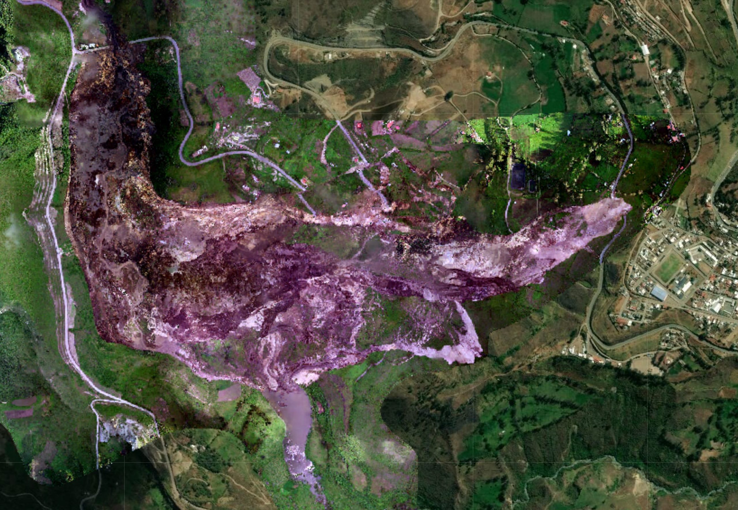
A vertical aerial photograph of the Chunchi landslide. Image uploaded to an online GIS portal attributed to the Servicio Nacional de Gestión de Riesgos y Emergencias / Instituto Geográfico Militar.
.
I thought it would be helpful to label the major features on first inspection. I would welcome comments:-
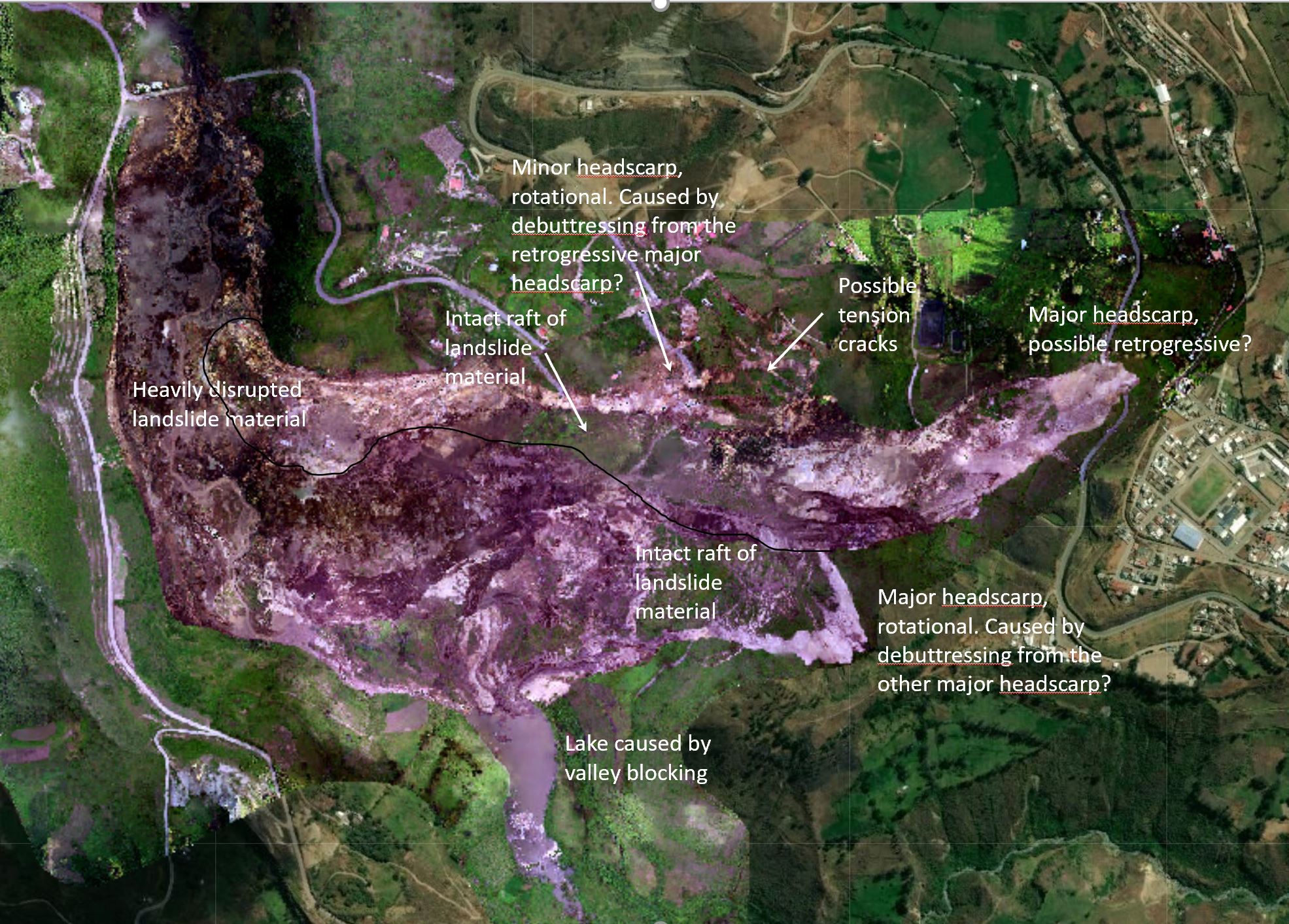
Annotated vertical aerial photograph of the Chunchi landslide. Image uploaded to an online GIS portal attributed to the Servicio Nacional de Gestión de Riesgos y Emergencias / Instituto Geográfico Militar.
.
There are two major headscarps in this landslide, which has a reported volume of about 30 million cubic metres. The one to the east appears to be retrogressive, the one to the southeast is rotational. Downslope from both there are large rafts of essentially intact land. There is a minor scarp to the north, and an areas of what appears to be very large tension cracks. I have drawn in an approximate boundary between the two flows from the major scarps. Downslope the landslide material us very heavily disrupted, which is consistent with the videos.
To the south there is small lake caused by the blockage of the valley.
The most likely mechanism is that one of the two major failure areas developed, driving the static liquefaction in the lower part of the slope. This then debutressed (unloaded the toe) of the other major failure. My hunch would be that it was the retrogressive failure that developed first, but it could be the other way around.
A third hypothesis is that a smaller failure developed lower on the slope, triggering a chain reaction upslope as the materials weakened.
This could only be resolved with fieldwork and eyewitness accounts. Sadly, Covid-19 is likely to hamper this work, but hopefully a locally-based team will be able to study it in detail. This is a landslide that justifies a detailed publication.
 Dave Petley is the Vice-Chancellor of the University of Hull in the United Kingdom. His blog provides commentary and analysis of landslide events occurring worldwide, including the landslides themselves, latest research, and conferences and meetings.
Dear Dave:
Here is a couple of perspective views before and after the event.
It seems to me that some of the scarps and tension cracks developed along, or parallel at least, to minor roads in the area. The 2012 Google Earth image shows interesting features near the NE scarp. It would be nice to look for some precursory signs in the area.
Regards,
Felipe
https://cdn.knightlab.com/libs/juxtapose/latest/embed/index.html?uid=bee59b86-7220-11eb-83c8-ebb5d6f907df
https://cdn.knightlab.com/libs/juxtapose/latest/embed/index.html?uid=08b01b00-7222-11eb-83c8-ebb5d6f907df
Google Earth oblique view shows most of what has moved is part of a large old slide mass. There is a well developed scarp in the source areas of both failures and Chunchi sits on an old bench immediately adjacent to the top of the scarp. I noted numerous other old slides throughout the region. Some vegetative clues suggest the bedrock is relatively flat lying?
Thanks for sharing your observations, I agree that it seems like Chunchi is located on top of an old landslide, which is shocking as well. I’m not that familiar with the nitty-gritty details of satellite imagery but would you mind elaborating on which are the changes in vegetation that indicate a flat-lying bedrock?
Is there any way to pinpoint where the videos were taken from? They seemed to show two different portions of the event, separated by either time or location.