5 December 2019
The Blackhawk rock avalanche – insights from imagery
Posted by Dave Petley
The Blackhawk rock avalanche – insights from imagery
A couple of weeks ago I posted about the remarkable Blackhawk rock avalanche in the USA. Since then my regular and highly valued correspondent who goes by the pseudonym funkenbeachin has been putting together some additional information to aid the interpretation of this very large landslide. I would like to highlight two really interesting and important things that he has done. The first is a really impressive and useful video, posted to Youtube, that combined the geological map of the site with multispectral satellite data. You should be able to view this below:-
.
Note that this uses Sentinel data. The annotation on the Youtube video page provides information about the sources of information and the band combinations used.
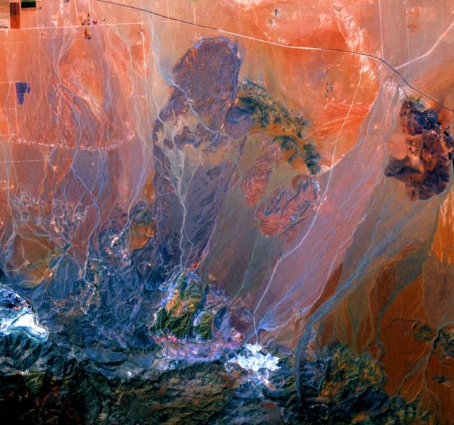
This is really interesting for a number of reasons. First, it illustrates really well the ways in which multispectral imagery can be used to provide insight into the geological processes in a complex location. The different geological materials provide different spectral responses when the satellite band combinations are changed. This means that it becomes possible to discriminate between different deposits that look similar under normal conditions, providing real insight into the evolution of the landslide. This band combination is a really good example:-

A multispectral image of the area around the Blackhawk landslide. Still from a Youtube video by funkenbeachin. Data from ESA Sentinel, collected on 28 June 2019.
.
There is fascinating geological complexity in this image, in the bedrock source area, the sediments on the plains below and the landslide deposit itself.
The second is the insight that this analysis provides into the evolution of the landslide itself. The very linear lateral eastern margin of the Blackhawk rock avalanche deposits for example is really interesting. I would be really interested to receive comments about your interpretation of the imagery.
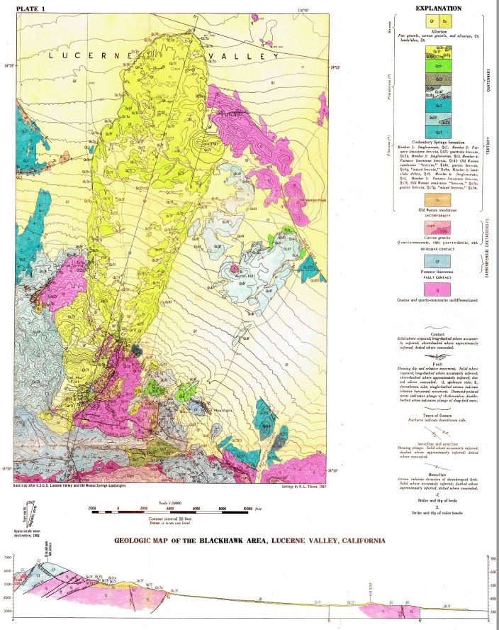
Funkenbeachin has also annotated and enhanced the digitased Shreeve geological map of the Blackhawk rock avalanche to make it easy to understand:-

The digitised Shreeve geological map of the Blackhawk rock avalanche. Image created by funkenbeachin.
.
He has very kindly provided a PDF of the map with far higher resolution than the image above – if you would like a copy then please drop me a line via [email protected]


 Dave Petley is the Vice-Chancellor of the University of Hull in the United Kingdom. His blog provides commentary and analysis of landslide events occurring worldwide, including the landslides themselves, latest research, and conferences and meetings.
During my undergraduate studies at UCSB in 1979-80 we went to the Blackhawk slide on a field trip. Several aspects of the slide that I still remember are that the debris on the toe of the slide is a different rock type than the upper portion and reflects the bedrock geology on the slope – toe material is from the base and upper part is from higher up the mountainside. Also there was not turbulent mixing of rock types – leading to the hypothesis that it slid on trapped air. I also recall that some snail fossils from ponded sediment in depressions on the toe had been age dated and it was late Pleistocene. After the original article I tried a quick literature search but couldn’t find anything that documented this. If interested I suggest you contact Dr. Ed Keller at UCSB. I think he is still an active emeritus and led the trip.