
11 September 2019
Xe Pian Xe Namnoy: Land stability and dam failure on the Bolaven Plateau, Laos
Posted by Dave Petley
Xe Pian Xe Namnoy: Land stability and dam failure on the Bolaven Plateau, Laos
A guest post by Richard Meehan and Douglas Hamilton
This progress report was prepared one year after the failure of the Xe Pian Xe Namnoy dam in Southern Laos and represents ongoing research into the causes of that failure by the authors. Early post failure studies were carried out by former dam designer Richard Meehan ([email protected]) with engineering geologist Douglas Hamilton, joining more recent efforts to consider implications for the future of the Xe Pian Xe Namnoy project and of dam building generally in similar upland areas of the Mekong basin.
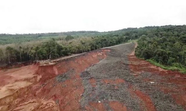
Figure 1:- The Xe Pian Xe Namnoy saddle dam failure, left abutment, from drone video. Courtesy Hankyoreh TV.
.
The mountainous terrain of landlocked Laos creates a natural buffer between its modernizing and expanding neighbors, China, Vietnam, and Thailand. In recent times Laos has been recognized as a potential hydropower asset which could modernize the country and its remote upland populations. The high topographic relief and rainfall prevailing over much of the country are attractive for the development of high-head power drops but the monsoon-driven summer timing of rain requires seasonal reservoir storage near the edges of high plateaus. The capital-short Lao government has exploited these inviting conditions by opening the country to external hydropower investment and design/construction management by its neighbors. However such ambitious plans to turn the country into a profitable “battery of southeast Asia” have stumbled on problems arising from cases of hastily built and inadequately supervised construction in remote areas on what has often proven to be unstable ground.
A notable recent example is the July 2018 failure, on first filling, of a billion cubic meter reservoir, constructed for the Xe Pian Xe Namnoy project located on the Bolaven plateau in southern Laos. An initial review of this failure by the first author were presented in late 2018, and was followed six months later by a review by an independent expert panel drawn by the Lao government from the International Committee on Large Dams (ICOLD). Both reviews concur in finding that the failure was caused by a foundation failure beneath one of the project saddle dams.
On further review by us it appeared that the geomorphologic evolution of the high-altitude terrain that provides nominally favorable dam sites also features geologic defects typical of tropical areas that tend to make the ground and supporting structures unstable. Thus we find evidence of a form of generic geologic ground instability that may exist for similar sites of dam construction, existing and proposed, in this region.
The 2018 failure received international news coverage and commentary, such as an article in the Asia Times.
A general representation of the terrain of the Bolaven plateau presents a complex pattern of planation, uplift or erosional isolation, development of a trilinear joint pattern, weathering and erosion, followed by volcanic eruption and partial overlay of lava on the older sandstone:-
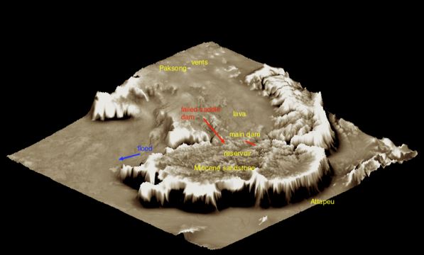
Figure 2:- Textured 3D model of Bolaven Plateau View north, with the Xe Pian Xe Namnoy project shown at the bottom edge of the lava field. Vertical scale exaggerated. See text for technique used.
.
If effectively dammed, the network of narrow canyons on the older rocks on the southern part of the plateau provides some limited reservoir storage. More recent volcanism has partially filled some of the lower reaches of these canyons with lava flowing from surface vents flooding down from the north. The high secondary permeability of lava and possibly the residual laterite soils that form on it lead to sink drainages. This in turn results in groundwater flows toward the edges of the plateau, and where at points downslope these flows converge and rise, surfacing of groundwater flow creates a dendritic pattern of canyons cut into the easily weathered basalt lavas. At the edge of the plateau, the groundwater feeds notable seasonal waterfalls. At the upstream margins of the lava flows, remnants of weathered basalt form surficial canyon blockages that appear to be topographically favorable for dams but are deeply weathered to typical lateritic tropical soils. It now appears that this assemblage presents potentially unstable foundation conditions for dams.
The first author developed an interest in the failure as a result of having once in the 1960s participated in the design and construction of a problematical dam at a site with similar geological conditions but located on the uplifted southern rim of the Korat Plateau 500 km to the west. That dam was American designed based on experience with many projects in the western US but reflected lack of experience with tropical geology. The result was a near accident similar to the 2019 saddle dam failure.
With this interest and background, following the 2018 failure the first author made application for access to data on the Xe Pian Xe Namnoy project. But the Lao government and the Thai and Korean investors and engineers involved had quickly imposed a general blackout on all information on the project that continues even today in mid 2019, a year after the failure, even as the reservoir, with partial repairs, is now reportedly scheduled for refilling to recover financial goals of the $ 1 billion investment.
Initial simplified diagnosis of the failure was facilitated by a Google Maps terrain view of the site (15.008, 106.653) which shows a sink drainage above the dam. Details are shown in the author’s diagnosis above but can be replicated in a minute or two by the reader by entering those coordinates in a web browser and setting Google Maps to terrain view.
Access to the failure site has been prohibited but regional geologic mapping developed cooperatively by Lao and Japanese geologists is available. A clearer picture of the local physical geography emerged via scalable textured visualizations including the geological mapping and combined with SRTM and ALOS (approximately 2005) satellite data. Such a representation is shown here for the Bolaven Plateau, figure 2. The model was developed in QGIS and exported for 3-D visualization to Blender. The surface texture was processed by applying a high pass filter to the same terrain data and draping it as a brown-and-white image onto the 3-D manipulatable Blender model with exaggerated vertical scale. This preserves the texture of the local topography, making it relatively easy to discern between rough old sandstone, to the south, and smooth lava flows, to the north. Figure 3 shows a closer view of the same terrain model with project reservoir, dams, and mapped geology distinguishing Mesozoic sedimentary rocks from overlying lava flows.
With project data remaining secret additional important geologic and hydrologic data were needed and found in various Japanese studies undertaken initially in the early 2000 decade in connection with bauxite exploration and for several proposed dam sites, all of which are located on the margin of the lava flows and all questioned as to suitability, probably because of the low ground water and high seepage potential of the basalt. Among those sites so identified and proposed was a site for the main dam of the Xe Pian Xe Namnoy project; investigations demonstrated some problems including one basalt abutment with a low groundwater table and high seepage potential verified by borehole pressure tests. The final dam site was subsequently shifted upstream to its present location presumably to avoid these conditions. All of this information is available in online reports by the Japanese aid agency and served to make a possible diagnosis without specific detailed site investigation data at Xe Pian Xe Namnoy, assuming such data even exist.
A closer view of the portion of the reservoir including the main and three saddle downs is shown in Figure 3. The area mapped as basalt by Japanese and Lao geologists is indicated in by purple shading and is a good match with the geology pattern inferred from the terrain texture modeling described above. The upper reaches of the lava at about elevation 850 m form 10 km of the rim of the reservoir.

Figure 3: Close-in view of textured terrain model at dam sites. Note the purple lobe of lava which forms 10 km of the reservoir rim requiring saddle dams to achieve the billion cubic meters storage needs. Lava also found downstream of the main dam, with its properties well defined by Japanese studies.
.
The inferred evolution of the terrain at the failed saddle dam site is shown in graphic sketches (Figure 4):-
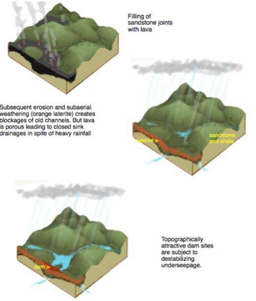
Figure 4: Thevolution of landscape at edge of a lava flow
.
With 3000 mm of annual summer rainfall it is evident that the underlying basalt was always able to convey a substantial subsurface flow beneath the saddle dam site, opportunistically located on a remnant basalt/laterite ridge lacking development of surface drainage. Here as at the other dams at Xe Pian Xe Namnoy and at yet more dam sites proposed for the Bolaven Plateau, the flow of groundwater in the basalt passes toward the edge of the plateau (in this case to the southwest), eventually emerging to the surface and creating dendritic pattern of incised canyons that is quite different from the trilinear joint pattern seen in the Mesozoic rocks.
The Japanese engineering geologists in their investigations have identified lava cooling joints as principal seepage paths, but other conditions promoting high and concentrated subsurface flow and erosion including those that might be associated with hot lava flowing in wet jungle canyons — volcanic tubes, brecciated zones, perhaps maar-like features, as well as uncompressed or open stress relief joints in the underlying sandstone can be readily proposed. Runoff deficits from sink areas including at the saddle dam site are quite large, consistent with experience elsewhere with losing streams in lava areas. Borehole water pressure tests taken at various of the rejected other sites on the plateau indicated high flows often exceeding the pumping capacity of the equipment.
A telling pair of photos of the dam crest a few hours before failure is shown in Figures 5a and 5b:-
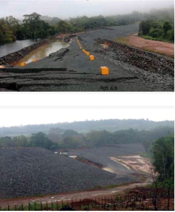
Figure 5:- News photos of saddle dam at Xe Pian Xe Namnoy hours before failure.
.
Both downward and lateral deformation of the dam are evident. The first author’s sketch of one of the hypotheses of the generation of this failure pattern is shown on figure 6. Note that the dam embankment does not include any drains or zoning that would protect against seepage failure of the embankment or relieve foundation water pressures. Alternative or complementary foundation seepage paths including eroded tunnels and cavities developing probably at the top of the basalt or between the laterite and basalt, or the basalt and the upper sedimentary rocks can also be imagined. Unprecedented uplift pressures beneath the cap of laterite developed. A large component of ground slippage toward the drone camera, i.e. away from the abutment, is suggested in figure 1. The general concept of a seepage induced foundation failure was initially advanced by the writer in October 2018 three months after the failure. The official government expert panel reportedly came to the same findings, but this report has never been released, reportedly out of deference to the Korean government.
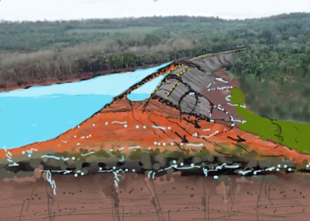
Figure 6: A sketch of failure hypothesis for the Xe Pian Xe Namnoy saddle dam.
.
A more ominous scenario for the 2018 failure involves the partial mobilization of the ridge area at and downstream of the left abutment of the dam along with a simultaneous failure at the saddle dam. This possibility is suggested both by the canyon-facing scarps in Figure 1 and also by the presence of a separate landslide on the left side of the canyon on ground not directly impacted by the saddle dam (Figures 7 and 8):-
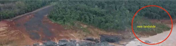
Figure 7:- A landslide downstream from the Xe Pian Xe Namnoy dam failure, which is unconnected to the dam.
.
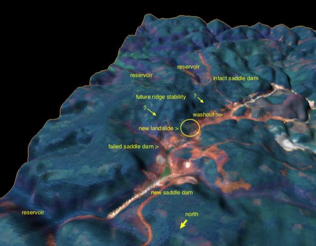
Figure 8: Potential instability of intact saddle dam and ridge area at Xe Pian Xe Namnoy . Post-failure satellite image draped on a 3D terrain model.
.
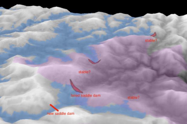
Figure 9: Textured terrain model showing potential instability in the high levels of weathered lava. Choice of a site for the new saddle dam that presents sandstone abutments suggests an awareness of the doubtful stability of basalt lavas.
.
Reportedly all of the saddle dams are to be replaced by new roller-compacted concrete dams. But adequate stability of the other two saddle dam foundations would surely need to be verified to allow this, considering the precedent of the famous 1928 St. Francis Dam failure. That too was taken to be superior in strength by virtue of its being made from concrete. But the St. Francis dam was fatally sited on a weak and weathered foundation (Figure 10). This case history renders the reported plan, if true, for construction of “strong” concrete dams on weak lava-derived foundations highly questionable.
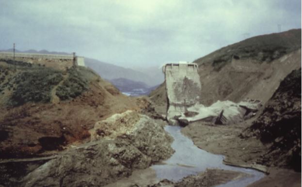
Figure 10: Remains of the concrete St. Francis dam built on weathered foundation rocks.
.
If, as mapped by the Japanese mining geologists, and suggested as well by the textured 3D models, the 10 km southwestern rim of the reservoir is underlain by deep laterite soil, leaky basalt, and weathered sedimentary rocks, the suitability of concrete dams must be considered. Moreover, a pattern of unstable ground could extend widely beneath the entire ridge between the reservoir and the canyon below the failed saddle dam. Generalized landslide slope failures along this ridge can be suspected from photographic evidence as shown in Figure 9. Immediate failure of the ridge might not occur because time would be required following filling of the reservoir to raise the water table to critical levels. A major failure of the ridge could be a greater catastrophe than the 2018 failure.
The severe social impact of the project and its failure last year have received censure from the UN and other parties. As of mid 2019 the viability and future of the Xe Pian Xe Namnoy project remains uncertain.
Richard Meehan and Douglas Hamilton. All views expressed are those of the authors.
 Dave Petley is the Vice-Chancellor of the University of Hull in the United Kingdom. His blog provides commentary and analysis of landslide events occurring worldwide, including the landslides themselves, latest research, and conferences and meetings.
Excellent article by Meehan and Hamilton.
Many thanks for this!
On the off chance you’ve missed them, give these articles on the St. Francis Dam a read. The SE abutment was built on an ancient slump/slide. https://web.mst.edu/~rogersda/st_francis_dam/
Similar to this Blogosphere presentations/analysis perhaps for all designers of Lao Hydro power projects will “further emphasize” using sattelite immagery/map generator to record part of the terrain/land topography/river bed surveying/scanner, historical volcanics and related research. More expensive but will result in elegant foundations and will lead to project success. Hopefully/pray the patch up that does in Xe Pian Xe Namnoy saddle dam has better resolutions on the situation that occurred and they need more “open consultations” & it will take a long time but it’s definitely for safer…8^