
20 August 2019
A high resolution Planet Labs image of the Pingdi landslide in China
Posted by Dave Petley
A high resolution Planet Labs image of the Pingdi landslide in China
The 23rd July 2019 Pingdi landslide in Shuicheng County in the city of Liupanshui in Guizhou Province, China is thought to have killed 51 people. This was a large, complex landslide associated with heavy rainfall. As is usual in China, after the initial reports of the losses and the heroic acts of the rescuers, little information has emerged as to the causes of the landslide. We can expect that it will be analysed in a research paper in due course, but this is unlikely to emerge for a year or so.
Planet Labs have however captured a high quality satellite image of the site, which they have kindly made available to me. Once again I am indebted to Rob Simmon for his help with this. The image was captured on 2nd August 2019:-
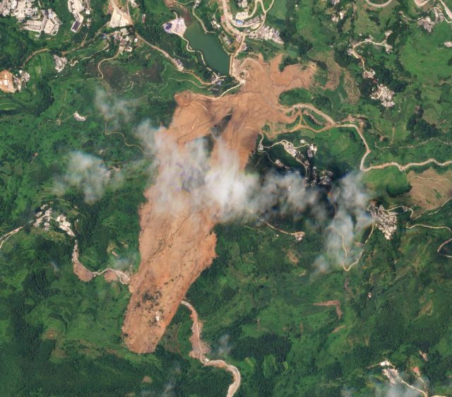
A Planet Labs SkySat image of the Pingdi landslide in Guizhou Province China. Image collected on 2nd August 2019, copyright Planet Labs, used with permission.
.
There are aspects of this landslide that are interesting:
- The road crossing the upper part of the landslide is clear. I have previously suggested that this may have played a role in the initial failure. Note the apparent fresh cuts on the upslope side of the road, suggesting recent widening. It is clear that a number of these cut slopes have also undergone small scale failures. I continue to wonder if this road may have been a key part of the failure process;
- There appears to be a number of other smaller-scale failures located in the vicinity of the landslide. This may indicated very localised, extreme rainfall;
- The runout behaviour of the toe of the landslide is quite complex, as this part of the image shows:
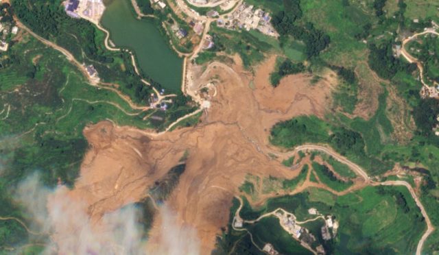
A Planet Labs SkySat image of the toe of the Pingdi landslide in Guizhou Province China. Image collected on 2nd August 2019, copyright Planet Labs, used with permission.
.
Further up the slope the landslide track bifurcated and then recombined before running out. On the right side of the images parts of the landslide debris have entered and followed existing channels, in one case crossing and blocking another road, To me this suggests quite high mobility.
Reference and acknowledgement
Thanks to Robert Simmon for his help in acquiring and processing the image.
Planet Team (2019). Planet Application Program Interface: In Space for Life on Earth. San Francisco, CA. https://www.planet.com/
 Dave Petley is the Vice-Chancellor of the University of Hull in the United Kingdom. His blog provides commentary and analysis of landslide events occurring worldwide, including the landslides themselves, latest research, and conferences and meetings.
Dear Dave,
Thank you very much for the blog! You really do a lot for the landslide community!
It is very difficult and often speculative to discuss landslides just on the basis of images. If possible, please send also profiles through the pass of the landslide. In case of the Pingdi landslide it would be interesting, which mass detached, where was the toe of the rotational slide (?) and where the runout began. A profile could help to understand these items.
Best regards,
Rainer
[The sort of detailed analysis you describe is beyond the role of this blog. It is for others to undertake; I try to highlight these more detailed studies when they are published. D.]
Dear Dave,
Sorry for the mistake: I meant “a profile through the path of the landslide”.
Thank you and best regards,
Rainer