
24 August 2018
Global fatal landslide occurrence from 2004 to 2016
Posted by Dave Petley
Global fatal landslide occurrence from 2004 to 2016
Yesterday, Melanie Froude and I published in NHESS our paper on global fatal landslide occurrence (Froude and Petley 2018). This paper is based upon the work that I have been undertaking since September 2002 to compile a database of events that kill people. I published a paper six years ago (Petley 2012) that summarised the findings, and there is an accompanying blog post that provides some explanation. The paper we have now published, which is open access, provides both an update to this dataset and some new insights into global losses from landslides.
The headline figure is that in total (excluding landslides triggered by earthquakes) about 56,000 people were killed by landslides over that period, in about 4,900 distinct landslide events. As expected, the majority of those landslides occurred in less developed countries in Asia, with particular hotspots in for example India, Nepal, Pakistan, the Philippines and Indonesia. We have looked carefully at the time series data as well – the graph below shows the full dataset, organised in five day blocks (pentads):-
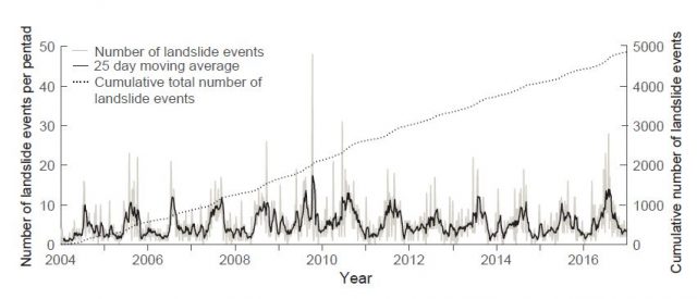
Global fatal landslide occurrence from 2004 to 2016 inclusive. Graph from Froude and Petley (2018).
.
The cumulative trend graph shows that we find no convincing evidence that overall landslide losses are increasing globally. The strong annual cyclicity in the data is evident too, which landslides peaking each year as the Asian summer monsoons generate failures in populated areas. But note that the shape of the annual cycle also varies hugely, presumably in response to variations in rainfall totals and locations. We know that this needs much more investigation, and we are working on it, but we suspect that we will need 30 years of data to understand it properly. The high quality dataset (i.e. from January 2004 onwards) is now 14 years old, and I have 17 years of my career left, so that analysis may be the one that I write as I retire!
I think the most interesting finding in this paper, and the one that goes well beyond anything we have done before, is in the patterns with time of landslides caused by humans. The graph below, from the paper, plots a range of human-induced landslide types with time:-
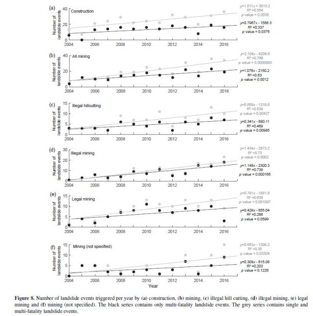
Global fatal landslide occurrence – losses from human induced mass movements. Graph from Froude and Petley (2018).
.
In most cases we have recorded an increase in losses with time for landslides triggered by humans. This is particularly the case for mining (especially illegal or unregulated mining) and hill cutting. Our strong sense is that these patterns reflect an increase in these activities in poorer countries, especially in Asia. These landslides are avoidable; they are in every case a tragedy.
I will post again on this early next week, but after considerable work we have been able to get the dataset online. Melanie has set up an ESRI ARCGIS system that allows the user to access the data and to generate maps using it. This has been an ambition for a long time, and we hope that it will be useful.
References
Froude, M. J. and Petley, D. N. 2018. Global fatal landslide occurrence from 2004 to 2016. Natural Hazards and Earth System Sciences, 18, 2161-2181, https://doi.org/10.5194/nhess-18-2161-2018.
Petley, D.N. 2012. Global patterns of loss of life from landslides. Geology 40 (10), 927-930.
 Dave Petley is the Vice-Chancellor of the University of Hull in the United Kingdom. His blog provides commentary and analysis of landslide events occurring worldwide, including the landslides themselves, latest research, and conferences and meetings.
EXCELLENT, so look forward to the online data… Continue the fantastic work.
There are more fatal landslides (2010 – 2016) due to rainfall and due to hill-cutting in the city of Guwahati (NorthEast India) which have not been accounted in the database. If the dates and locations are required along with the corresponding local news items, please feel free to write to me.
Can these data be downloaded now?
Fantastic geologic occurances. Pity and sadness for those on the Earth and under the sea.
I live 150 miles from the Oregon Coast where I grew up.
I hope and pray for your research and help for all beings to be safe and well.
There are always Geologic forces all the time.
Thank you all.