
14 October 2011
A very large landslide on the Vesta Asteroid (and a challenge for you!)
Posted by Dave Petley
Summary: New NASA imagery of the Vesta asteroid appears to show a very large landslide. The challenge is to find a good terrestrial analogue to this slip.
The NASA Dawn mission is currently imaging using a range of instrumentation to image the Vesta asteroid. A few days ago they released this fascinating image of the South Polar region, showing a huge “mountain” . This feature is 22 km high – about three times the height of Everest. Note the strange topographic features around it, but note also that the image is exaggerated vertically by about 50% and has had the underlying topographic curvature (the same effect as the curvature of the Earth) removed.
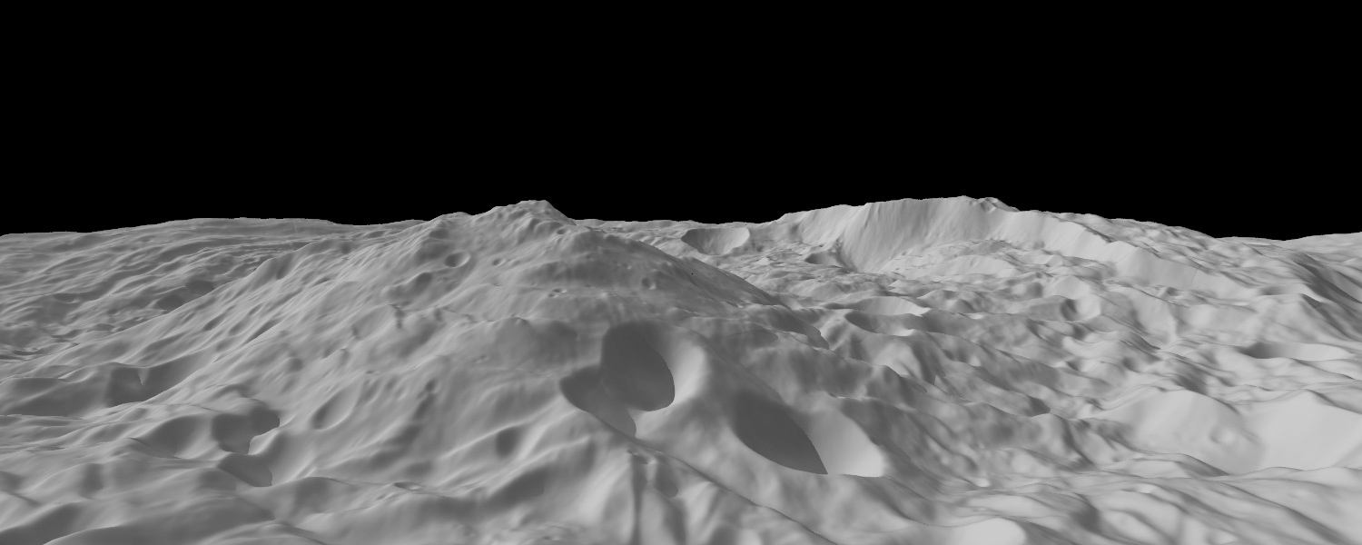
Whilst the image itself is really interesting, for me the most fascinating aspect is the tall ridge on the right side, shown enlarged here:
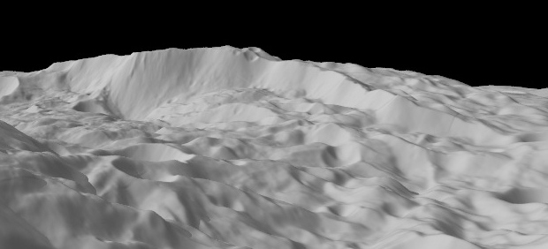
The NASA hypothesise that the deposits at the toe of this scarp, especially on the centre right I suspect, are those from very large landslides. I suspect from the morphology that this is correct. In the image below I have highlighted in black the main block that I would interpret as being a landslide (note the boundaries are indicative at best):
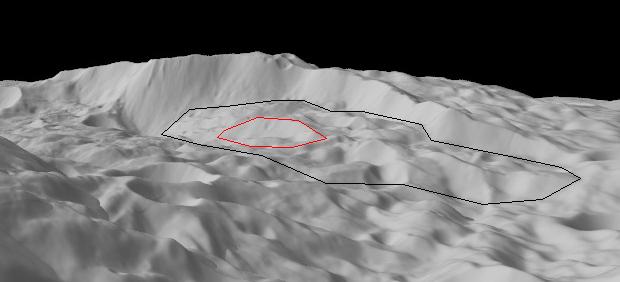
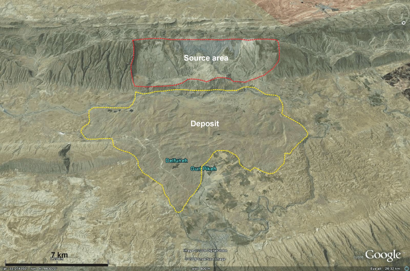
The area that I have high;lighted in red appears to be a small secondary slip in the landslide mass. It is interesting that the very large main landslide complex appears to have slipped but not to have spread in the way that the Saidmareh landslide appears to have:
I have been trying to think of a terrestrial analogue. So far the best I can come up with is the Quiraing on the Isle of Skye, but this is not really a good analogue overall.
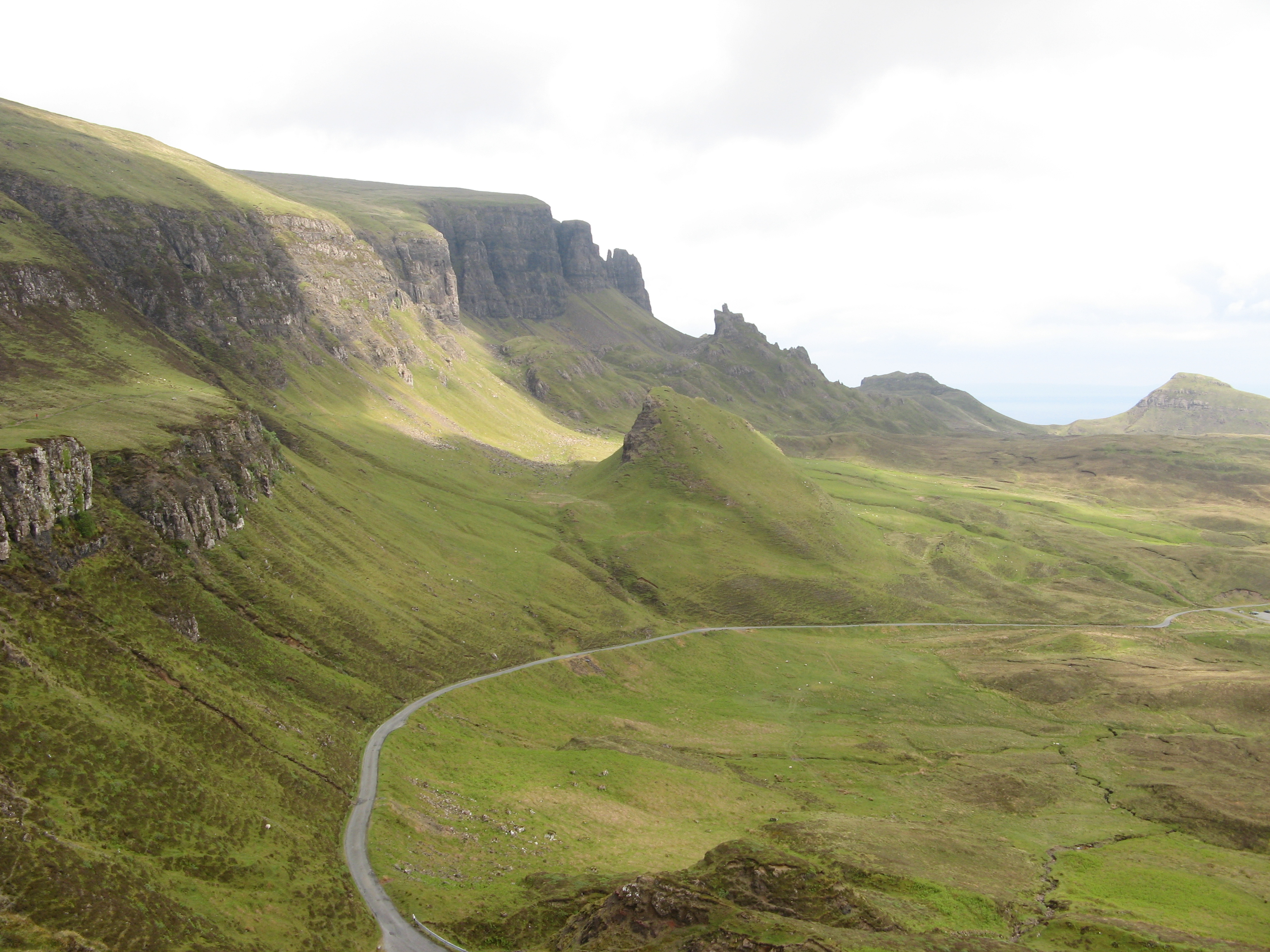
http://www.panoramio.com/photo/43503956
There must be much better examples, so over to you. I’ll try to post the best suggestions here over the next few days.
 Dave Petley is the Vice-Chancellor of the University of Hull in the United Kingdom. His blog provides commentary and analysis of landslide events occurring worldwide, including the landslides themselves, latest research, and conferences and meetings.
Is there some other feature, maybe even on the opposite side, that shows that this objects mass or momentum was effected? Even passing a larger gravitational body?
I found on the British Geological Survey website an interesting case. The Folkestone Warren landslide (UK) is a deep seated event affecting the coast, further informations are available here :
http://www.bgs.ac.uk/landslides/folkestoneWarren.html
As noticed above for the Vesta Asteroid landslide, the observation of the black and white picture would suggest that the deposits did not spread and the accumulation area is located just downstream of the main scarp.
The west side of Summer Lake in Oregon hosts some deep slides, and a few could be a terrestrial analog — at least in terms of general appearance.
There is one here:
N 42.82701 W 120.81991
I would suggest the landslide on January 9, 1965 in the Nicolum Valley near Hope, British Columbia. Wikipedia has a brief account about it.
As a 10yo kid I visited the Hope Slide from 1965 shortly after a road was pushed through the debris field. The fascinating observation to me was how the debris from the slide had apparently sloshed 1-200m up the opposing mountain slopes, then back and forth down the valley several miles. The path of the flow was obvious from the complete denudation of vegetation, in this case a rain forest with some hefty trees. It was the first time I realized that rock could act like a fluid given the gradation and compression characteristics were suitable.
Here’s a side view of Vesta’s ‘slide’ from the right:
http://goo.gl/niQJs
And a top view:
http://goo.gl/BxJsv
Given the larger context, it looks like a scarp from a caldera collapse to me. In this case perhaps frozen water sublimed causing a collapse of dust and gravel. Slow acting ice volcano caldera. Heh.
Another example of a large collapse located in the North of Chile is the Lluta Collapse:
http://www.springerlink.com/content/n12714n7801663h1/
What about this one:
http://serc.carleton.edu/vignettes/collection/31904.html
what about this one near Beichuan:
http://maps.google.com/maps?q=http:%2F%2Fujap.de%2Fstatic%2Finteresting_landslide.kmz&hl=en&ll=31.808664,104.436754&spn=0.0061,0.007156&sll=31.805227,104.442505&sspn=0.008762,0.011222&vpsrc=6&t=h&z=17
As on the asteroid, there are scarps of more recent flows (not slides) on top of the original slide.
I wonder to what extent you can expect to find a similar slide on Earth. Given the low gravity at the surface of Vesta (just 2% that of the earth) I would expect very low acceleration of the slide material, giving the slide very little momentum and a low velocity. That would easily explain why the mass did not spread. Do landslides on earth ever happen at such a low velocity?
I am certainly no specialist, just offering my thoughts.
This is a recent slow one that I remember hearing about. It may meet your definition of low velocity:
http://en.wikipedia.org/wiki/Aldercrest-Banyon_landslide
While it isn’t as big as many others, there is this old one that was likely faster. It dammed and changed the course of the Columbia River between Oregon & Washington.
Sorry, forgot to include the second link.
http://columbiariverimages.com/Regions/Places/bonneville_landslide.html
[…] del acantilado y sus alrededores indica que en ésta pendiente se pueden haber producido grandes deslizamientos de tierra . El origen del acantilado sigue siendo desconocido, pero partes de su pared deben ser bastante […]
A larger earth landslide simular to Vesta, which I just heard about, is the underwater landslide to the north of the Hawaian island Molokai. Evidently half the island collapsed. I saw this on the Science Channel… USA television, about 3-4 months back.
[…] space rock earlier this year. The topography of the scarp and its surroundings indicates that huge landslides may have occurred down this slope. The scarp’s origin remains unknown, but parts of the […]
Parts of the English south coast are continually unstable, with frequent landslips. A god example is the Black Ven near Charmouth.
See: http://www.g6csy.net/fossil/Black%20Ven.html
and near Lyme Regis.
See: http://news.bbc.co.uk/1/hi/england/dorset/7386923.stm
The frequent exposure of fossil bearing strata is one reason for this being dubbed the “Jurassic Coast”.
John
[…] Topografie des Steilhangs und seiner Umgebung lässt vermuten, dass an diesem Abhang gewaltige Landrutschungen stattfanden. Der Ursprung des Abhangs ist unbekannt, doch Teile der Klippe selbst sind wohl […]